From east to west, West 5th north of Fennell could have: a northbound vehicle lane, a centre turn lane, two southbound vehicles lanes and a protected two-way cycle track.
By Ryan McGreal
Published March 04, 2016
The City's Cycling Master Plan, Shifting Gears 2009, doesn't start from the premise that every street should be considered for cycling infrastructure. Instead, it defines a specific network of streets that should be considered, with recommendations for what kind of infrastructure should go on a given street.
The streets that are identified in the plan are the only streets that might get bike lanes under the current framework, so we really cannot afford to miss opportunities to add them. Unfortunately, while there is no clear way to add streets to the plan, there are lots of ways for bike lanes to be removed from the plan.
For this reason, I have described Shifting Gears as a "ceiling" on what we might get in terms of cycling infrastructure.
A recent case in point is the reconstruction of West 5th Street between the Escarpment and Mohawk College. The Cycling Plan proposes bike lanes on West 5th Street from the Escarpment all the way to Rymal Road.
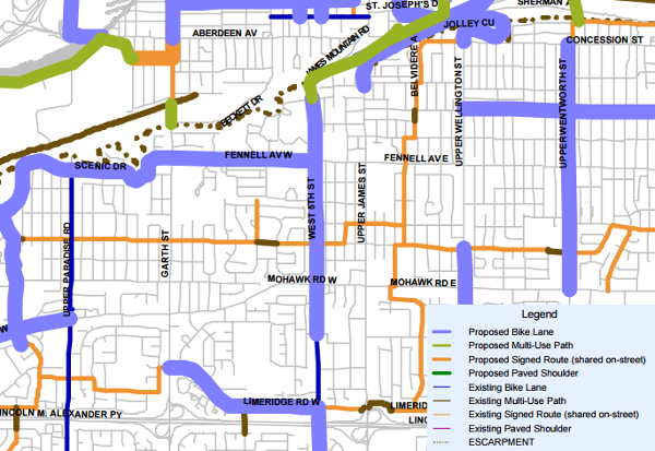
Bike lanes planned for West 5th in Cycling Master Plan
To the north, the bike lanes would connect to the proposed multi-use path running up and down the Claremont Access, which staff have said they cannot complete for close to two years despite Council recently voting to make it a priority after a man was killed commuting home up the Claremont on his bike.
To the south, the bike lanes would connect to the existing bike lanes that are already on West 5th between Mohawk Road and Stone Church Road.
The City already reconstructed West 5th between Mohawk and Fennell, and instead of adding bike lanes they decided to paint sharrows on the curb lanes.
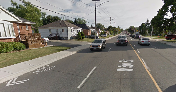
Bike sharrows on West 5th between Mohawk and Fennell (Image Credit: Google Street View)
A bike sharrow is not cycling infrastructure. It is simply a paint marking on the street advising that a person riding a bike is allowed to ride in the vehicle lane - a circumstance that is already legal on every non-highway street in Ontario.
Recent traffic research in Denver, the city that invented sharrows in the early 1990s, has found that sharrows may actually be more dangerous than nothing at all. The study authors conclude:
As sharrows do not provide designated space for bicyclists and do not enhance the overall bicycle network, all cities should (as many already have) begin to consider sharrows simply as signage as opposed to actual infrastructure. It is time that sharrows are exposed for what they really are, a cheap alternative that not only fails to solve a pressing safety issue, but actually makes the issue worse through a sense of false security.
More recently, the City finished reconstructing West 5th between Fennell and the escarpment. This section is a bloated five wide lanes and does not even include the tokenism of painted sharrows.
RTH enquired as to why bike lanes were not included in the reconstruction. Ward 8 Councillor Terry Whitehead, whose ward includes West 5th, forwarded an email from Daryl Bender, the City's Project Manager for Cycling:
The Cycling Master Plan (CMP 2009) included a plan for bike lanes on the full length of West 5th Street from the Brow southerly to Rymal Road. From the Brow to the lower city the same plan envisions a multi-use trail.
The design works, a few years ago, for West 5th Street north of Fennell Ave determined that the best that could be accomplished was sharrows because of insufficient roadway width in some segments. Secondly, an on-street facility would not connect very well to the multi-use trail northerly (along the Brow). The decision was therefore made to pursue a multi-use trail along the west side of West 5th Street so the multi-use trail at the Brow would be continuous to Fennell Ave (i.e. Mohawk College). Alternatively this facility could be a bike path beside a sidewalk along the hospital property. It is envisioned that Mohawk College will be a suitable location to transition from the multi-use trail/bike path to on-street cycling infrastructure southerly.
Current updates to both the Recreational Trails Master Plan and the Transportation Master Plan (TMP/CMP) both reflect this plan for future cycling connectivity.
Sharrows exist on West 5th Street south of Mohawk College to Mohawk Road; and south of there, bike lanes now exist all the way to Stone Church Road.
Of course, there is only "insufficient roadway" for bike lanes because the street design has five lanes for vehicle traffic.
We looked up the City's most recent traffic volume counts for West 5th, which were taken in 2010. The following table records the north- and southbound counts at various locations:
| Location | Southbound | Northbound | Total |
|---|---|---|---|
| At Brantdale Ave | 11,223 | 6,292 | 17,515 |
| At Fennell Ave W | 9,319 | 7,942 | 17,261 |
| At Monarch Rd | 9,429 | 8,188 | 17,617 |
| At Governors Blvd | 10,327 | 7,777 | 18,104 |
| At South Bend Rd W | 9,237 | 8,647 | 17,884 |
| At Richwill Rd | 9,846 | 8,928 | 18,774 |
| At Mohawk Rd W | 6,765 | 7,705 | 14,470 |
| At Marlowe Dr | 6,901 | 7,695 | 14,596 |
| At Tyrone Dr | 7,611 | 7,541 | 15,152 |
Here is the same information displayed as a bar chart:
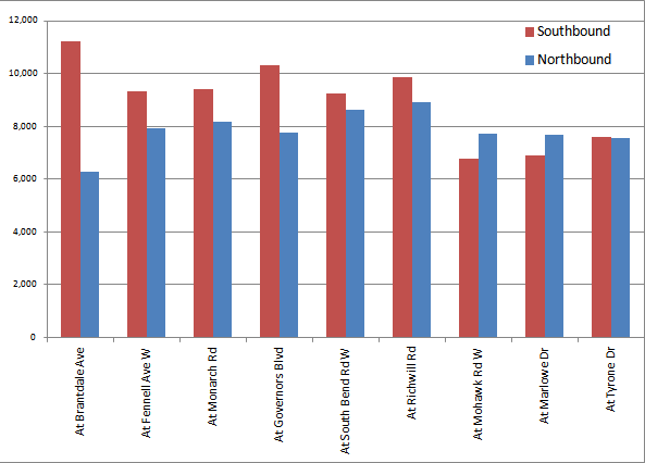
Chart: traffic volumes on West 5th at various locations
Look at the asymmetry of traffic volumes north of Mohawk - more traffic is southbound than northbound. This makes sense: the southbound lanes are fed by both the James Mountain Road access and the Claremont Access extension, but for northbound traffic, only James Mountain Road is a through route - and it is only one lane in each direction.
So why is West 5th five lanes wide? It only carries some 17,000 cars a day, and north of Fennell, almost two-thirds of that is southbound. Since James Mountain Road is only one lane northbound, West 5th only needs to be one lane northbound, especially north of Fennell.
That frees up a full lane that could be used as a protected two-way cycle track connecting between the planned Claremont cycle track and the major destinations at West 5th and Fennell: Mohawk College and St. Joseph's Healthcare West 5th campus.
From east to west, the street could have: a northbound vehicle lane, a centre turn lane, two southbound vehicles lanes and a protected two-way cycle track.
Again, those two southbound lanes would be fed from the two southbound escarpment access lanes, one on Claremont and one on James Mountain; and the one northbound lane would feed the one northbound escarpment access lane on James Mountain.
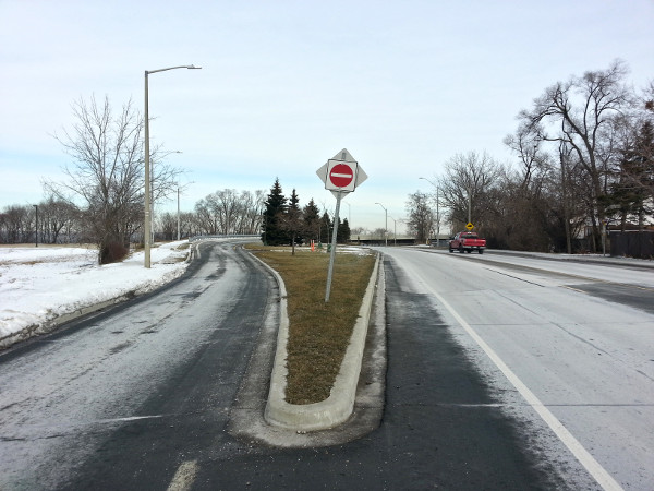
From left: southbound lane from Claremont, southbound lane from James Mountain, northbound lane to James Mountain
We don't even need to engage in guesswork on how well this arrangement would work. Yesterday afternoon, more than a day and a half after this week's snow storm ended, the north curb lane of West 5th was still piled with snow.
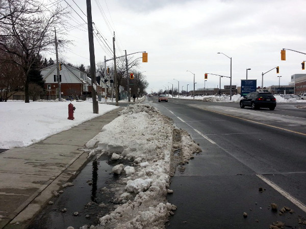
Northbound curb lane of West 5th piled with snow on March 3, 2016
Snowfall is a great way to figure out how much roadway a city actually needs. The paths that cars make through the snow on a street function in the same way as a desire path, demonstrating how much of the roadway is superfluous and could be repurposed for other uses.
A couple of years ago, Streetsblog founder Aaron Naparstek coined the term sneckdown to refer to places where undisturbed snow demonstrates that roadway is not needed for automobile traffic and should be converted to other uses.
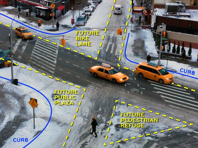
Sneckdown in New York City (Image Credit: Aaron Naparstek/Wikipedia. Licenced under Creative Commons Attribution-Share Alike 3.0 Unported)
So why were the bike lanes not included in the West 5th reconstruction? At its very busiest, it only carries 18,000 cars a day. That volume of traffic warrants a street with one lane in each direction and a centre turn lane.
But this is Hamilton, where we habitually overbuild our streets so that no one ever has to slow down, even during the busiest peak of rush hour.
Councillor Whitehead actually introduced a motion at the February 29, 2016 Public Works Committee meeting (item 9.1, which I can't link directly thanks to the City's unusable-by-design meetings website) requesting that the City set a target for improving the appropriate vehicle traffic Level of Service (LOS) for peak rush hour vehicle traffic on city streets from a Level D or better to a Level C or better. The Public Works committee approved it.
Here are the City's definitions for the various levels of service:
| LOS | Description |
|---|---|
| A | This Level of Service describes the highest quality of traffic flow and is referred to as free flow. The approach appears open, turning movements are easily made and drivers have freedom of operation. Control delay is less than 10 seconds/vehicle. |
| B | This Level of Service is referred to as a stable flow. Drivers feel somewhat restricted and occasionally may have to wait to complete the minor movement. Control delay is 10-15 seconds/vehicle for unsignalized intersections and 10-20 seconds/vehicle for signalized intersections. |
| C | At this level, the operation is stable. Drivers feel more restricted and may have to wait, with queues developing for short periods. Control delay is 15-25 seconds/vehicle at unsignalized intersections and 20-35 seconds/vehicle at signalized intersections. |
| D | At this level, traffic is approaching unstable flow. The motorist experiences increasing restriction and instability of flow. There are substantial delays to approaching vehicles during short peaks within the peak period, but there are enough gaps to lower demand to permit occasional clearance of developing queues and prevent excessive back-ups. Control delay is 25-35 seconds/vehicle at unsignalized intersections and 35-55 seconds/vehicle at signalized intersections. |
| E | At this level capacity occurs. Long queues of vehicles exist and delays to vehicles may extend. Control delay is 35-50 seconds/vehicle at unsignalized intersections and 55-80 seconds/vehicle at signalized intersections. |
| F | At this Level of Service, the intersection has failed. Capacity of the intersection has been exceeded. Control delay exceeds 50 seconds/vehicle at unsignalized intersections and exceeds 80 seconds/vehicle at signalized intersections. |
According to the Wikipedia page on LOS, LOS D "is a common goal for urban streets during peak hours, as attaining LOS C would require prohibitive cost and societal impact in bypass roads and lane additions."
In other words, in a city with a cumulative unfunded infrastructure maintenance deficit of $3.5 billion, Whitehead actually wants the City to aim for a level of service such that streets never experience congestion, even during rush hour.
In this he is ignoring the recommendations of his Public Works managers, who acknowledge that the City could save money by scaling down the excess capacity on our city streets.
Think about the staggering amounts of money we would have to spend on expanded road infrastructure to achieve this goal - not to mention the fact that the law of induced demand means that expanded road infrastructure would attract more people to drive longer distances more frequently - and then remember this the next time Councillor Whitehead claims we can't afford something or that we need to focus on "needs" versus "wants".
The decisions we make about how to allocate scarce, expensive public resources demonstrate our values. This was the same multimillion dollar reconstruction that could not bother to squeeze a few feet of right-of-way on Fennell Avenue to make room for a skinny north curb sidewalk, despite the clear desire path from people trying to walk without getting killed.
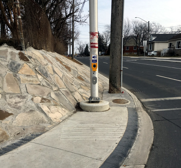
No sidewalk on north side of Fennell east of West 5th
Whitehead has claimed that the City couldn't put a sidewalk there due to the sloped grade next to Auchmar, but this is a red herring. Even if we set aside the fact that five lanes is excessive for the 18,000 cars a day that drive on this section of Fennell, it would have been easy to take a bit of space from each of those wide lanes in order to make room for a sidewalk outside the sloped grade.
Whitehead also claims that traffic volumes are increasing, but by designing our streets for cars to the exclusion of other modes, we are preventing people from choosing other ways of getting around.
In a statement he posted yesterday on twitter, Whitehead argued:
@63_King it is an arterial road and also a mnt access. Three major institutions
— Terry Whitehead (@terrywhitehead) March 3, 2016
on Fennell. Volume of traffic justifies need.
This blinkered reasoning behind this is astonishing: the major institutions are precisely why the street network needs to be more inclusive! How many students would love the opportunity to walk or ride a bike safely to school?
We get the city we plan and build for. Hamilton has been planning and building for a city of universal driving for decades and it is bankrupting us, even as our car-centric transportation system leaves far too many people behind.
By Riddle Me This (anonymous) | Posted March 04, 2016 at 11:22:35
Question for Mr. Whitehead.
Which do you value more; your legacy or your paycheque?
By JasonL (registered) | Posted March 04, 2016 at 11:35:29
The next Brooklyn.... hahahaha Ok
If Brooklyn is suburban Miami, then yes (minus the nice weather and beaches)
By JasonL (registered) | Posted March 04, 2016 at 11:38:04
I'm stunned that there actually is a level of road network that can be even wider, faster and more dangerous than the one we already have. Massive infrastructure deficit, lousy underfunded transit system, and 2nd most dangerous streets in Ontario. Hey, I have an idea. Let's make our streets even wider, faster and more dangerous than they already are!
By NortheastWind (registered) | Posted March 04, 2016 at 11:59:24
I don't understand how one person (i.e., ward Councillor) can have veto power over deciding cycling infrastructure in a city ward. This should be a city wide decision made by the planning department and only vetoed by a vote by city council.
By JasonL (registered) | Posted March 04, 2016 at 12:16:25 in reply to Comment 116821
its' how most other cities work. Here, everything goes through council which is why we hear comments like "we'll look at gondolas in 35 years. We're too swamped right now building 1 transit line". Look at all the amazing city-building happening in Toronto right now, and over the last 5 years and next 5 years. We won't see that much city-building in the next 200 years here because of our system that is set up to fail and grind everything to a snails pace.
By KevinLove (registered) | Posted March 04, 2016 at 12:40:30
In places that care about human life, major institutions have transportation access for people, not cars. Here is a video of one example:
By Mr.Chips (anonymous) | Posted March 04, 2016 at 14:30:40
urbantoronto.ca/news/2016/03/bloor-street-bike-lane-pilot-project-proposed-summer-2016
By DowntownInHamilton (registered) | Posted March 04, 2016 at 20:15:52
I'd love to see the cycle path revamped. In fact, it's one of the identified needs of our neighbourhood and we will be pursuing having more cycling lanes put in, such as along Lime Ridge Road since there's a massive paved median, a school, lots of residential, and can hook up with existing bike lanes on West 5th.
By mountain66 (registered) | Posted March 04, 2016 at 20:19:35
Iliving just off West 5th we really looked forward to the street being redone but now ironically I wouldn't be surprised to see them have to put in speed bumps, it's just too good right now. I suspect what they are trying to do is make West 5th take traffic off Upper James and turn it into an urban expressway to serve the new builds south of Stonechurch. Prior to the upgrade there were no left turn lanes or the totally useless island at Gateview, also traffic calming was put in North of Brantdale making it only one lane northbound past that point. If the left turn lane and island were eliminated there would plenty of room or widen the sidewalk on St. Joe's property. It is worth noting that about 75% of the houses on West 5th between Gateview & Mohawk are student rentals with absentee landlords,so they could care less about anything in the city. Also if the Claremont bike lane is actually built the logical way to connect would be to use the North lane on the Claremont to West 5th connector, it reduces to one lane at West 5th anyway so it would not effect volume at all, then widen the existing sidewalk & make it multi-use. However if that was the plan in mind, why didn't they simply put in a multi-use path in the first place?
Comment edited by mountain66 on 2016-03-04 20:33:45
By mountain66 (registered) | Posted March 05, 2016 at 09:32:03
I don't dispute that a multi use path is safer and more desirable. In my opinion the cheapest safest way to do it would have been to make a multi use path on the St. Joe's property. If you are not familiar with the area a new sidewalk was built from where the walkway on the north side of the Claremont to West 5th connector joins West 5th. The new sidewalk is slightly wider than normal and has soldier bricks on both sides. Prior to the rebuild there were no sidewalks on the west side from the brow to south of Mohawk College. If the proposed bike lane on the Claremont is built I still think continuing it along the connector, using to right lane (with some type of barrier)is a good option. Then if the new sidewalk was made wider it could be joined where the right lane merges into one going south. The sidewalk could be widened to south of Mohawk college and no doubt would be more expensive than doing it in the first place but probably cheaper than trying to reconfigure the rebuilt roadway. Perhaps you are unaware that they are building an HSR hub at Mohawk College that would make this even more desirable.
By JasonL (registered) | Posted March 05, 2016 at 09:50:06 in reply to Comment 116849
this was suggested repeatedly to city staff before St Joes began construction and was rejected. This is the suggested location now of the aforementioned bike path as it was requested by public feedback during the recent trails master plan update.
You're right, would have been way easier to do it while the site was an empty field.
By mountain66 (registered) | Posted March 05, 2016 at 14:15:45 in reply to Comment 116833
On another post you suggested I try & form a neighbourhood group. I have been informed there is one & Councillor Whitehead's assistant is the Chairperson. I will email her for meeting times and a copy of the agenda from their last meeting.
By JasonL (registered) | Posted March 05, 2016 at 15:21:23 in reply to Comment 116828
compare that to us building a little suburban street like West 5th with 5 lanes. Lol
By BobL (anonymous) | Posted March 06, 2016 at 10:05:25
I drive West 5th every day and there are never any delays even during rush hour. At Fennel and Mohawk you never have to wait more than one light cycle to go through the intersection. I don't recall ever seeing a car use the centre lane to turn into a driveway. With four lanes of roadway
the centre lane is completely unnecessary. When I contacted councillor Whitehead to ask why bike lanes were not included to the college his response was there was not enough room and it would require reconstructing the street. What??? It's a shame Whitehead is so narrow sighted and has such little consideration for anything other than moving cars as quickly as possible. Another missed opportunity to help make this a better city to live in,
By mountain66 (registered) | Posted March 06, 2016 at 13:55:49 in reply to Comment 116861
The only time you will see a backup on West 5th is northbound in the morning. It will backup from the bottom of the access from the lights at St. Joes. What they really need is a sign like there used to be when the access was one way in the afternoon directing the traffic to the Claremont access at Brantdale, making a left to go northbound at Upper James & Inverness is very difficult & dangerous at those times. They could also put the white posts in like they have around city hall to direct the traffic across Brantdale at all times, West 5th merges into one just past that point. You will seldom see people turning left into the houses on West 5th from Gateview to the Auchmar property because most of those houses are student rentals and few have cars.
Comment edited by mountain66 on 2016-03-06 14:02:08
By DowntownInHamilton (registered) | Posted March 09, 2016 at 21:49:26 in reply to Comment 116851
Go for it! I hope that you're able to join your neighbourhood association and be an agent of change in your area!
You must be logged in to comment.
There are no upcoming events right now.
Why not post one?