By making use of the informal trail east of St. Joseph's Drive, we can add a new cycle track that enables lots of rich connections without taking away driving lanes.
By Jason Leach
Published February 01, 2016
RTH recently published articles looking at opportunities to connect the Claremont Cycle Track at the bottom and the top of the escarpment, but we haven't yet given a lot of attention to the middle section.
The Claremont Access crosses Arkledun Avenue - the Jolley Cut Access - partway up, and it turns out there is a really exciting opportunity to add some amazingly rich additional connections between the upper and lower city without a lot of cost or difficulty.
This proposal knits together several current, planned and future cycling and walking routes that connect up and down the escarpment. It all starts at the eastern end of St. Joseph's Drive with a path that can connect the Jolley Cut and the planned Claremont cycle track and the Ferguson Avenue bike route!
Let's start at the end of St. Joseph's. Behind the fence, a trail continues to the east.
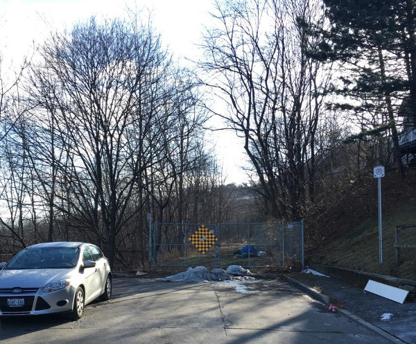
Eastern end of St. Joseph's Drive
From this spot, you can look north and down to the top of Ferguson Avenue:
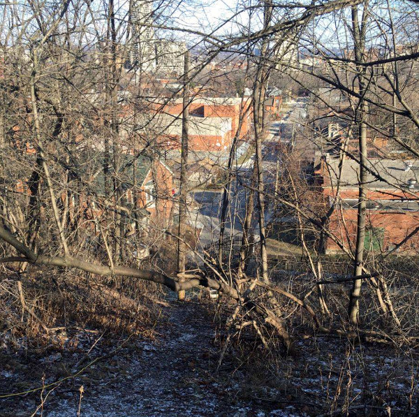
Looking north at Ferguson Avenue
Look east and you connect to the Claremont Access on the same side as the planned Cycle Track:
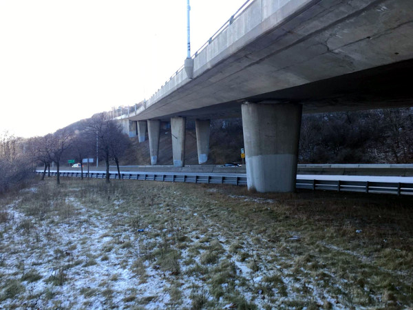
Connection to Claremont Access
Now turn south and you're looking up to the Jolley Cut access.
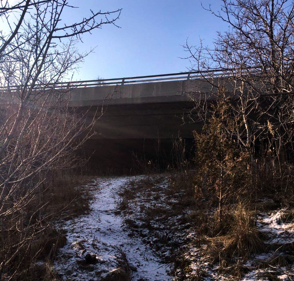
Looking south at Jolley Cut
In fact, there's even a fairly level path between the north side of the Claremont Access, where the Cycle Track will go, and the north side of the Jolley Cut just before the overpass that goes over the Claremont.
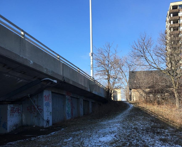
Path connecting to Jolley Cut
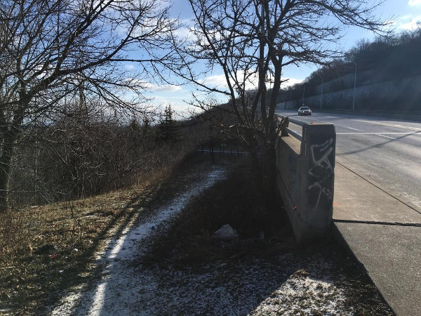
On the Jolley Cut looking back down the path
Walk around this area and you can't help but notice all the desire paths from people already informally using these routes to navigate around our gargantuan escarpment accesses.
Now let's tie these all together.
I'm proposing that we formalize the path running east from the end of St. Joseph's to connect with the Claremont Cycle Track. A staircase with bike gutters or a switchback path can extend north to connect to the top of Ferguson Avenue, and another path or staircase can extend south to connect with the Jolley Cut.
Here's where it gets really interesting: the Jolley Cut is about 15 metres (50 feet) wide where the St. Joseph's trail joins it, just before the Claremont overpass starts. It gets even wider east of this point, where the useless current skinny painted upbound bike lane begins. That means we have significantly more than 15 metres to work with.
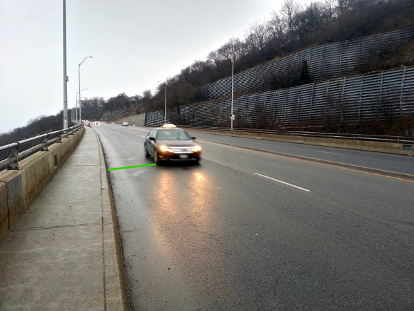
Lanes on the Jolley Cut are very wide (Image Credit: Ryan McGreal)
The Jolley Cut is four very wide lanes, two in each direction. We can follow best practices for lane widths and narrow them to 3 metres (10 feet) each. That leaves three or four metres of width to install a jersey barrier-protected cycle track.
It makes the most sense to install it on the north downbound side. At the bottom it can start at the St. Joseph's Trail. From there, it continues all the way to Upper Wellington, which could also get bike lanes with some leadership. The big useless lawn area at the top can be shaved into, if necessary, to create space for the starting point of the cycle track at the top.
The track could be designated as a wide shared-use path along the straightaway between the St. Joseph's connection and where the current narrow sidewalk diverges. That way, we also add the space currently used by the narrow protected sidewalk, which the City doesn't snow-clear because you can't fit a bobcat. (We might even be able to reuse the existing jersey barriers to save some money!)
That way, people on bikes also have the option of taking the walkway (with stairs and bike gutters) over to Concession east of Upper Wellington.
But through the Jolley Cut switchback, it's much safer to make it a cycle track only and leave the pedestrian traffic on the existing separated walkway.
This is an incredibly easy addition to Hamilton's cycling network. We don't need to remove any driving lanes, just narrow the dangerously wide lanes we've got and add some off-street trail connections. We don't have to figure out any complicated intersections either.
A cyclist heading downbound and exiting at the St. Joseph's Trail connection can: continue west on St. Joseph's Drive to John Street; turn north on the switchback trail or staircase to Ferguson Avenue; or turn east and join the downbound Claremont Cycle Track.
St. Joseph's Drive between John and James is currently one lane westbound and two lanes eastbound. We can switch it to one lane each way with bike lanes in both directions, allowing people on bikes to ride west to James and connect with the Markland contraflow bike lane and the soon-to-be-installed bike lanes on Charlton and Herkimer.
On John Street between St Joseph's Drive and Charlton, there may even be enough space to narrow the lanes and make room for bike lanes in both directions. This will connect to future planned bike lanes on Charlton Avenue East.
And of course, Ferguson Street is already a designated cycling route, albeit without dedicated bike lanes.
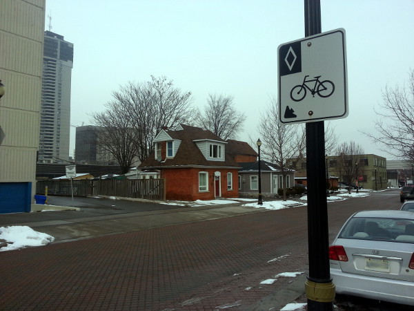
Ferguson is a signed bike route (RTH file photo)
This could become a vital connection between the central Mountain/Concession Street district and the downtown core.
Remember, the Jolley Cut is already identified as a cycling route in Shifting Gears, the city's Cycling Master Plan. The skinny partial one-way bike lane on there now just doesn't cut it. By physically protecting it, making it two-way and connecting it to the St. Joseph's Drive trail, we create a legitimate, high-quality connection - without taking anything away from people driving.
In fact, the narrower lanes will make the street safer for everyone by curbing dangerous speeding.
One more thing: with proper signage and wayfinding we can also raise the profile of the venerable Bruce Trail, which runs right through this area along both accesses - on the Jolley Cut toward the east and next to Claremont toward the west. This is a wonderful treasure running through the city and very few people even know about it.
With files from Ryan McGreal.
By IanReynolds (registered) | Posted February 01, 2016 at 07:41:00
Living on the section of St Joes between James and John, I've recently thought about asking the city to install... something.. to slow traffic down. Cars turn left from James using that dual-left turn lane, and then SCREAM down St Joe's trying to make the light to go up the Jolley. There are kids waiting for busses and cars driving 85 km/hr to beat the light.
Would speed bumps work in the mean time? And would turning the 2 lanes of east-bound St Joes into a 1 lane also reduce traffic speed?
That issue aside, this is a really interesting article. I walk most of these paths regularly and never even thought they could be connected, especially because I think the East end of St Joes is guarded by a fence? This connectivity plan would be wonderful.
By Pxtl (registered) - website | Posted February 03, 2016 at 12:27:55 in reply to Comment 116296
My dream for the area has always been
1) Block left-turns through most of John Street except for major intersections and get it to be a proper 4 lanes for its entire length, including boarding the Jolley (why is it only 1 lane up-bound?). This is the most direct route from King/James and so it should be the best. Get rid of the silly TWINO thing.
2) Add bike lanes to James South and St. Joe's.
3) Add a bike-friendly mountain access there.
By DowntownInHamilton (registered) | Posted February 01, 2016 at 19:39:26 in reply to Comment 116296
By jolley short cut (anonymous) | Posted February 02, 2016 at 13:48:34 in reply to Comment 116308
You must be picturing the wrong stretch of street
By DowntownInHamilton (registered) | Posted February 03, 2016 at 12:19:29 in reply to Comment 116316
What section is that? I'm referring to St. Josephs between James and John, I am not aware of any other stretch that would match this description.
By jolley short cut (anonymous) | Posted February 03, 2016 at 14:36:18 in reply to Comment 116334
Oh ok, yes you are right.. I also love going for a stroll on this nice quiet street that dumps traffic on via double left turn lane and clears it off at 60 km/hr using a highway style ramp.
Everyone knows you hate downtown so why don't you just stay out of their business?
Oh it's because you actually LOVE downtown.. as a shortcut. So self centered... nothing better to do than go on the internet to tell people their neighbourhoods should be your personal indy 500. go away.
By DowntownInHamilton (registered) | Posted February 04, 2016 at 15:53:52 in reply to Comment 116343
Oh ok, yes you are right.. I also love going for a stroll on this nice quiet street that dumps traffic on via double left turn lane and clears it off at 60 km/hr using a highway style ramp.
I don't agree with any of those assessments, and stand by my comments.
Everyone knows you hate downtown so why don't you just stay out of their business?
Actually, I don't. While I certainly am not downtown like I was when I lived there, I still visit there regularly for friends, establishments and the like. We could flip this around and say, "you hate the suburbs, so why don't you stay out of their business?" but if we did this site would cease to exist.
Oh it's because you actually LOVE downtown.. as a shortcut. So self centered... nothing better to do than go on the internet to tell people their neighbourhoods should be your personal indy 500. go away.
I don't use the lower city as a shortcut as it's rarely faster than using the highways we have. Please don't put words in my mouth. You're clearly out of your element.
By z jones (registered) | Posted February 03, 2016 at 13:03:40 in reply to Comment 116334
People in the reality based community are not aware of any stretch that matches YOUR description.
By DowntownInHamilton (registered) | Posted February 04, 2016 at 15:54:49 in reply to Comment 116338
Thanks for your 2 cents. As always, you've added a lot to the conversation. I do appreciate having my own personal troll though. I'll call you jackasz jones.
By KevinLove (registered) | Posted February 01, 2016 at 18:41:53 in reply to Comment 116296
"Living on the section of St Joes between James and John..."
Kevin's comment:
Wow! The part of that street that isn't residential goes right through St. Joseph's Hospital. Any sane City Council would have designated this a Community Safety Zone.
But, you know, its Hamilton...
Comment edited by KevinLove on 2016-02-01 18:43:26
By highasageorgiapine (registered) | Posted February 01, 2016 at 10:00:18
the problem with the excellent ideas presented by members of this site is that they are too logical and reasonable, and those ideas are not really permitted to fly in hamilton.
By Roundabout (anonymous) | Posted February 01, 2016 at 10:10:02
The jolley cut track doesn't have to go all the way to Upper Wellington, just end it where the sidewalk turns into the path and save even more money.
By Pxtl (registered) - website | Posted February 01, 2016 at 10:24:30
I think Ferguson actually is supposed to have bike lanes. They've just faded into invisbility. There used to be bike markings, iirc, although not painted lines. I think the slight change in color of the bricks near the curbs is intended to demarcate the bike lanes.
By JWilbur (registered) | Posted February 01, 2016 at 10:55:33
This is a wonderful set of ideas and it would be a positive step forward for bike infrastructure in Hamilton. With it's natural beauty, Hamilton COULD be leader in demonstrating how an intelligent attitude toward cycling can help drive urban renewal. It's time for an attitude revolution in this City to reseed the beds and grow something we want to live in.
By mountain66 (registered) | Posted February 01, 2016 at 17:44:27
I live on the Mountain between Upper James & West 5th. We use the stairs that connect Upper James to James & the Bruce trail path that connects to John Street, as well as the sidewalk on the Jolley Cut.. We emailed our Councillor early in January to request signage for both the stairs & the path as we are not sure most people are aware they are there. I know that since St. Joe's moved some of the out patient clinics we regularly have people stop & ask how to find the stairs from the top so I imagine the bottom isn't much different. We will see how asking for signs goes considering our Councillor seemed unaware there was a bike lane on the Jolley Cut.
In my opinion as a mostly recreational cyclist the bike lane on the Jolley Cut is on the wrong side, in many trips walking it I have only seen one cyclist using it & he was obviously an experienced cyclist judging his speed, however, we often encounter cyclist using the sidewalk.
While in Europe we saw a fair number of shared pedestrian / cycle ways and they seemed to work well, some were marked & some were just signed to tell pedestrians to stay right. I think it is unfortunate that this approach wasn't taken when the Jolley Cut was recently redone, as a shared path could have been added on the down bound side and the lanes narrowed and shuffled over.
As for the Claremont Cycle Track, one lane has been eliminated on the down bound side so it shouldn't make any impact to take out the up bound curb lane and barrier it with Jersey curbs. One of the other posts shows many options at the bottom, but I am thinking about the top.
Right now 2 lanes on the Claremount curve around to join West 5th, however when it joins West 5th it blends into one. I would suggest continuing the barriers all the way to West 5th reducing it to one lane all the way, as it reduces to one anyway.
Councillor Whitehead seemed to think West 5th has a bike lane, but it starts at Mohawk College & ends at Mohawk Road (both sides), unfortunately it is narrow where James Mountain Road & the Claremount connection meet.
When St. Joe's took over the old HPH we were told at meetings that they would return the north grounds back to way grounds were & remove the parking lot they put in during construction, since this hasn't happened & brand new sidewalks installed I would suggest the following: Widen the sidewalks from the escarpment to Fennell & make it a shared pedestrian/ cycle path similar to the ones we saw in Europe, in compensation for not returning the grounds the way they promised. At that point join the cycle path from the Claremount to the new shared path, if possible allow the newly built Juravinski Dr. connecting with Brantdale to be used as a cycle path connecting to the west side of Mohawk College leading into Governor's Road.
It seems to me this approach would blend the proposed path in so we don't end up with another bike lane that just seems to start & drop you off into a high traffic zone.
Comment edited by mountain66 on 2016-02-01 17:50:54
By DowntownInHamilton (registered) | Posted February 01, 2016 at 19:46:01 in reply to Comment 116304
Is that in Duvall's old area or Whitehead's? If it's in Whitehead's, I can see if our neighbourhood planning team (Rolston NAP) can help lend a hand with getting the signs installed. Please let me know.
By mountain66 (registered) | Posted February 02, 2016 at 10:37:25 in reply to Comment 116309
We are in Ward 8 so that would help. Please let me know more info on your NAP. Thanks
By DowntownInHamilton (registered) | Posted February 03, 2016 at 12:18:03 in reply to Comment 116314
Our NAP is for Rolston and Yeoville (Mohawk - Upper James - The Linc - Garth). It's out of our area but is always something we could bring up to help you in your neighbourhood. Please feel free to send us an email at rolston.planning.team@gmail.com or visit our Facebook page at https://www.facebook.com/rolston.neighbo...
By RobF (registered) | Posted February 02, 2016 at 14:53:42
Great piece. Excellent to see some detailed feedback from someone on the Mountain. How do we work to get this implemented? Any thoughts. It is an interesting opportunity to do some lower-city/mountain connecting, both literally as well as in terms of creating linkages between residents and neighbourhoods.
By Matt Pinder (anonymous) | Posted February 02, 2016 at 20:10:33
What an innovative ans simple idea! I live at St Joseph's and John and have been stumped about how to achieve safe pedestrian/cyclist access up Jolley. This idea just makes so much sense. Do you plan to talk to a councilor about it?
By jim (anonymous) | Posted February 04, 2016 at 06:56:32 in reply to Comment 116318
By Midge (anonymous) | Posted February 04, 2016 at 07:47:27 in reply to Comment 116361
Want to drive up the mountain? Just load your car onto a train and get it carried up! No wait, that's stupid. The only reason not to ride a bike up the mountain is there is no safe way to do it, thanks to selfish douchebags like jim who refuse to share a sliver of the road they're not even using.
By jim (anonymous) | Posted February 14, 2016 at 04:55:08 in reply to Comment 116362
By Glend1967 (registered) | Posted February 14, 2016 at 08:52:11 in reply to Comment 116528
Ive riden up the mountain literally thousands of times,in my younger years.Now its nice to be able throw it on the bus..or do both.
By Older rider (anonymous) | Posted February 04, 2016 at 09:15:02 in reply to Comment 116362
The reason I wouldn't ride up the escarpment is in my experience its way to physically challenging and riding down I fear the speeds I reach
By Midge (anonymous) | Posted February 04, 2016 at 09:26:05 in reply to Comment 116365
You're right, it's too hard for you so nobody should have a chance to do it safely.
By Older rider (anonymous) | Posted February 04, 2016 at 10:38:02 in reply to Comment 116366
Didn't say that. Answered your sarcastic question with a legitimate answer
By Midge (anonymous) | Posted February 04, 2016 at 11:11:13 in reply to Comment 116367
You answered why YOU don't want to ride up the mountain, you didn't answer why NOBODY should get to ride up the mountain.
By Older rider (anonymous) | Posted February 04, 2016 at 12:57:05 in reply to Comment 116370
You said it was stupid and there was no reason, I gave you a solid one.
By JasonL (registered) | Posted February 02, 2016 at 20:45:10 in reply to Comment 116318
yes, a discussion has been initiated. Let's keep fingers crossed that the idea gains traction. Certainly a simple/affordable win-win.
By mdrejhon (registered) - website | Posted February 06, 2016 at 18:36:07 in reply to Comment 116319
Keep all of us updated. I like this idea!
In a large quantity jersey barriers are really cheap for simple installations (e.g. no other major infrastructure like new traffic signals, or ripping up roads)
By Jeremy_S (registered) | Posted February 08, 2016 at 17:40:22
The cops often have speed traps on the Jolley Cut anyhow. Narrowing the lanes should reduce traffic speed a bit.
You must be logged in to comment.
There are no upcoming events right now.
Why not post one?