The proposed design is a huge improvement on the status quo, but it can be improved further with a few adjustments.
By Kevin Love
Published August 26, 2016
The city has published a proposed design for the Claremont Access cycling facility and included detailed drawings [PDF].
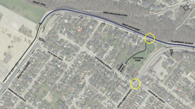
Upper portion
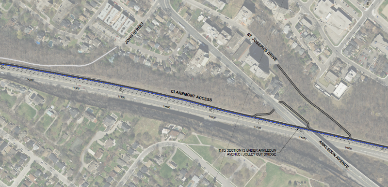
Middle portion
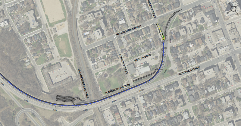
Lower portion
Overall, the proposals for the Claremont Access mark a big step upwards from what we currently have. This is important because the Claremont Access provides key links for people to travel from A to B for many popular destinations.
Examples include St. Joseph's Hospital, the Hunter Street GO Station and downtown Hamilton. The Claremont Access also provides connections to the Escarpment Rail Trail and other key active transportation infrastructure.
However, there are some problems with the proposed design. On a path with a width of as little as three metres, it is proposed to mix upbound cyclists, downbound cyclists and pedestrians.
Simply coasting downhill will result in people reaching speeds of 40-50 km/hr. This is quite safe in itself, but mixing those bicycle speeds with pedestrians is not.
Currently, there are no sidewalks or any other pedestrian infrastructure on the Claremont Access. If pedestrian traffic is to be accommodated on the new infrastructure, this should be done by way of providing a sidewalk for pedestrians.
In several places on the drawings, the proposed design puts a "Multi-Use Path" right next to a pedestrian sidewalk. One example is on the drawing entitled "West Fifth Street Pathway Figure #7."
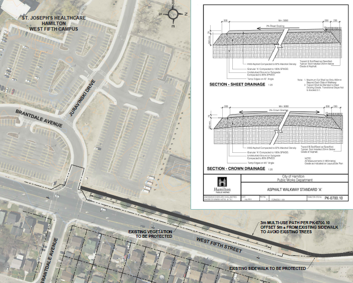
West 5th Street pathway
There are notes: "EXISTING SIDEWALK TO BE PROTECTED," and "3m MULTI-USE PATH PER PK-0700.10 OFFSET 5m +/- FROM EXISTING SIDEWALK TO AVOID EXISTING TREES."
In this and every other case where there is a sidewalk, this should not be a multi-use path. It should be a cycling-only path and the sidewalk should be pedestrian-only.
Another dangerous situation is seen in the proposed design on Figure #13, entitled "Hunter Street and West Avenue connection." This proposed design places a "Stop" sign directed at cyclists at the bottom of the Mountain at Hunter Street.
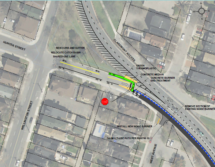
Hunter Street and West Avenue Connection
It is always Not Recommended to place Stop signs at the bottom of hills. It is human nature that people who have put so much effort into going up the hill will be very reluctant to have all that effort wasted by stopping at the bottom after coasting down.
That makes the currently proposed design problematic, particularly because there will be a large volume of traffic heading to the Hunter Street GO station and downtown destinations.
Fortunately, this problem is easily fixed. Hunter Street is currently one-way Westbound except for the last block east of Wellington Street. This last block should also be made one-way Westbound and right-of-way given to traffic on Hunter Street at its intersection with Wellington. The existing Hunter Street bike lanes can then be extended to connect seamlessly with the Claremont Access.
Hunter Street currently has right-of-way at the next three intersections travelling West, which are at Spring Street, Liberty Street and Ferguson Avenue. This should not be changed at these three intersections.
This fix enables someone to coast down the Claremont Access, and then seamlessly continue coasting Westbound on Hunter Street. This prevents wasted effort and momentum, and enables considerable savings of time and effort for people travelling to the GO station or other destinations. Most importantly, it avoids the dangerous situation of the present design.
By jordanfranks (registered) | Posted August 26, 2016 at 09:33:27
According to the Claremont Access Cycling Facilities – Criteria Rating Table from the Openhouse, looks like they can fund almost every other project for the same cost of the Claremont Project at $1.8M.
By Pxtl (registered) - website | Posted August 26, 2016 at 09:35:43
Looking at the designs, I was a little worried about the comparative lack of elaboration on the Upper James connections.... to me the UpperJames and St Joe's connections are the most important ones, since they connect the bike track to more central locations than the "default" endpoints do.
Also, I had one small request: a lookout / parkette halfway up. At the spot where the Claremont widens from 3 lanes to 4, there's an opportunity to claim some space for the bike track by delaying the widening of the car lanes. Clear some of the brush to open up the view and put some benches and a picnic table there, so leisure-cyclists can have a nice break in their climb.
By JasonL (registered) | Posted August 26, 2016 at 11:58:51 in reply to Comment 119873
I would suggest narrowing the traffic lanes by a foot or two each which would free up tons of space for a pedestrian path next to the cycle track. That might also help keep drivers from doing 120km/hr since it's built like a 400-series highway.
By kevinlove (registered) | Posted August 26, 2016 at 13:52:54 in reply to Comment 119873
That is a great idea! This would provide excellent separation of pedestrian and motor vehicle traffic. That would provide a pedestrian path that would be very pleasant to use.
By DowntownInHamilton (registered) | Posted August 26, 2016 at 22:14:43 in reply to Comment 119876
When was the last time a car went 120 along there? As much as it helps tell your story, that's hyperbole. Sure, there's speeding and it needs enforcement, but shrinking the lanes there would only make it more unsafe for the vast majority of drivers who _don't_ speed.
Enforcement is the answer.
By mountain66 (registered) | Posted August 26, 2016 at 22:52:09
http://www.hamiltonnews.com/news-story/6825360-skelly-wants-to-make-upper-james-pedestrian-friendly/ "Donna Skelly wants to see more trees, boulevards and other amenities added along Upper James to make it safer and more welcoming for pedestrians." Maybe there is still some chance of some changes on Upper James. My wife & I attended the info. session and I would say I thought the plan is fairly good. One thing I thought is missing is connecting east on the Mountain. Presently the city is in the process of installing traffic lights at the intersection of Upper James and Inverness Ave, these have been badly needed for many years. The suggested crossing now would require you to take your bike up some stairs and through Southam Park to connect with Inverness West at Tanner St. Tanner is more like an entrance to the park and the path they show is really just a desire path used to go through the park. If it is possible to make a second crossing closer to the bend coming off the access and create a bike lane to the new lights you could easily connect from Inverness East to the existing bike lane on Queensdale or connect to the Mountain Park path. It is really too bad the down bound lane closest to the escarpment is unusable as that would have solved separating cyclist going down from pedestrians and up bound cyclists.
Comment edited by mountain66 on 2016-08-26 22:53:20
By JasonL (registered) | Posted August 27, 2016 at 08:35:22 in reply to Comment 119882
go sit on the shoulder today and you'll clock someone at 120. Happens everyday. Narrow lanes are proven to help keep speeds slow. Sure, some will always break the law and speed, but at least it won't feel like it's the 401 for the average driver who drives according to road condition.
By kevlahan (registered) | Posted August 29, 2016 at 10:46:36 in reply to Comment 119882
Actually, the police have stopped at least one driver doing 132 kmh on Claremont in the middle of the day:
https://hamiltonpolice.on.ca/community/n...
On Tuesday April 12, 2016, just shortly after 11:00am, a Hamilton police officer was in the area of Main Street East and the Claremount Access conducting traffic related enforcement.
While situated in the area, the officer observed a 2016 Toyota Corolla travelling southbound along the Claremont Access, which he suspected was speeding well above the posted 70km/hr speed limit.
The officer then used a speed measuring device and obtained a reading of 132km/hr. The officer proceeded to stop the vehicle.
Comment edited by kevlahan on 2016-08-29 10:49:41
By mdrejhon (registered) - website | Posted August 30, 2016 at 08:49:29 in reply to Comment 119882
Enforcement is part of the answer.
Fixed it for you... Road design also plays a role.
FWIW, it is indeed easily possible to hit 120kph for a stretch without fearing for your life on the Claremont -- it shouldn't easily be possible to feel calm at 120kph on Claremont.
Comment edited by mdrejhon on 2016-08-30 08:50:48
By JasonL (registered) | Posted August 30, 2016 at 08:56:29 in reply to Comment 119908
you're correct.
And road design plays a WAY bigger role than enforcement. Just look at what Sweden has done to get serious about Vision Zero.
This has been proven over and over around the world. Enforcement is one small part of the solution.
By Pxtl (registered) - website | Posted August 30, 2016 at 09:46:59 in reply to Comment 119883
Agreed. That's my biggest worry about this project - the Upper James connection is a very important one, and it sounds like they're making a bad compromise on it. The document they released was extremely sparse on details about that connection, so hopefully that one they're still figuring out. I'm sure the big worry with using the obvious crossing right at the split is the speed of traffic - there used to be a crossing there and it's been closed off. But imho, trying to make that crossing work would be the best option.
Observe:
and a desire path leading up to that barrier!
Comment edited by Pxtl on 2016-08-30 09:47:31
By mdrejhon (registered) - website | Posted August 30, 2016 at 13:04:48
I emailed Daryl Bender to let him know that I would like the bike lanes to stay on the south edge of Hunter, as a contiguous cycle track all the way.
Please, no stop sign at the bottom of the hill.
By mdrejhon (registered) - website | Posted August 30, 2016 at 13:07:36
Another thing is about seeing if this can be safely made as a multi-use trail, so pedestrians can enjoy walking up Claremont Access, on the scenic edge.
High-speed downhill bike signage on the innermost edge (southern edge, adjacent to barrier from car lanes)
Pedestrians signage on the outermost edge (northern edge, the scenic edge)
Uphill bikes can either go in the middle or share with pedestrians -- uphill bikes will usually go slower than a jogger's speed, anyway.
Comment edited by mdrejhon on 2016-08-30 13:09:16
By mountain66 (registered) | Posted August 30, 2016 at 13:57:15 in reply to Comment 119913
That opening was put in for the 2003 Bike race, the same as the turn around where the access ramp joins at West 5th. I'm not sure it would be a bad crossing point as it actually is more visible than the existing one right at the stairs from Southam Park.
Comment edited by mountain66 on 2016-08-30 13:58:29
By Pxtl (registered) - website | Posted August 30, 2016 at 16:00:22 in reply to Comment 119927
Exactly. Ideally we'd see something similar to the (admittedly mediocre) treatment they gave the King/403 Eastbound ramp crossing. Put some knockdown sticks and extend the white line so the ramp beings further away from the crossing, and then draw the crosswalk lines there. Give drivers time to commit to the W5 ramp and to clearly delineate the space, and then put the crossing in the natural space.
Also, since the Claremont is now going to be 2 lanes upbound for much of its length, the span from the fork to the proper beginning of Upper James could be similarly 2 lanes... which means bike lane up a short span of claremont/upper james!
In Q&D picture:
Comment edited by Pxtl on 2016-08-30 16:01:24
By acanadianyoda (registered) | Posted November 22, 2016 at 14:29:31
I submitted a lengthy response to the city (daryl.bender@hamilton.ca) but to date have not heard anything further or seen anything on the plan/study site.
Has there been an update of any kind?
By blatchdk (registered) | Posted November 23, 2016 at 08:53:11 in reply to Comment 120453
This was just posted in The Spectator yesterday: http://www.thespec.com/news-story/698043...
tldr: Because they've dragged their feet on other cycling projects, this project is likely to break ground 2018 at the absolute earliest.
Comment edited by blatchdk on 2016-11-23 08:54:12
By acanadianyoda (registered) | Posted November 28, 2016 at 14:34:53 in reply to Comment 120456
Thanks, I missed that. Dismal news.
You must be logged in to comment.
There are no upcoming events right now.
Why not post one?