This active transportation infrastructure is gentle, integrates nicely into an existing neighbourhood, balances the needs of different modes, and provides significant improvements for walking, cycling and local quality of life without inconveniencing any
By Ryan McGreal
Published March 22, 2018
Voting has just begun for the Ward 1 Participatory Budget, which has a final list of projects under consideration for funding in 2018. I would like to draw your attention to an idea I proposed which made it onto the final list: a Neighbourhood Greenway on Kent, Pearl and Magill streets. It is Project #5 on the list.
A neighbourhood greenway (sometimes called a bicycle boulevard or a bikeway) is a low-volume residential side street that allows local automobile traffic but is designed to give priority to walking and cycling and to deter automobile through traffic.
According to the Portland Bureau of Transportation: "Neighbourhood Greenways are residential streets with low volumes of auto traffic and low speeds where bicycles and pedestrians are given priority."
Greenways are low-stress, friendly streets that make cycling accessible to people who are not comfortable cycling in mixed traffic or in painted lanes on a busy street.
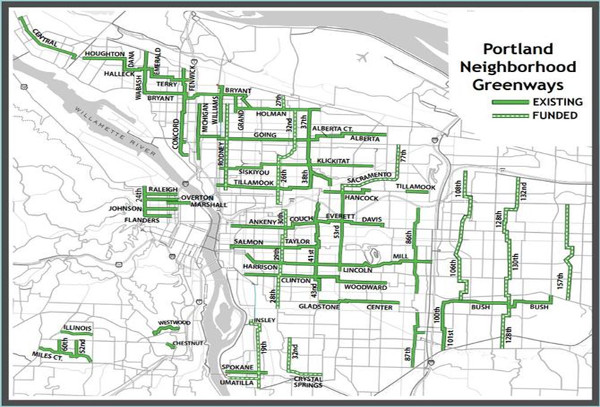
Map: neighbourhood greenways in Portland, Oregon (Image Credit: PBOT)
The first greenways were built in the early 1980s when German cities began building fahrradstraße or bike-priority streets. They are currently in use in several North American cities, including Vancouver, Minneapolis, Austin, Portland, Seattle, Chicago, Berkeley, Palo Alto, and Montreal.
Through trial-and-error, other cities have settled on a number of design elements that have proven to be effective at calming vehicle traffic and encouraging more walking and cycling.
Greenways were actually proposed in the original Shifting Gears cycling master plan for Hamilton that was approved in 1999, but none were ever built.
Successful neighbourhood greenways have a number of common features:
Low automobile traffic volumes - this model makes the most sense on already-quiet side streets, and a well-designed greenway further reduces vehicle traffic
Traffic calming and speed management - physical design elements encourage slow, safe vehicle speeds and deter cut-through driving, like bumpouts, speed humps, chicanes, pavement markings and street art
Physical barriers - design elements that force automobiles to turn but allow walking and cycling to proceed, like diverters, road-blocking bollards and sections of off-street path
Safe intersection crossings - signs, signals and design elements give priority to people walking and cycling across intersections with busier cross-streets
Destinations and Network Connections - effective greenways connect to local destinations as well as a broader city-wide network of accessible cycling routes
Wayfinding - signs, markings and even branding guide people through the greenway network to destinations
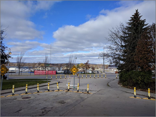
Physical barriers at Hughson and Guise allow walking and cycling but prevent cut-through driving
Based on the common features of successful neighbourhood greenways, the north-south corridor encompassing Magill Street, Pearl Street and Kent Street makes an excellent candidate for Hamilton's first neighbourhood greenway. This route meets the preconditions for a neighbourhood greenway and already includes many of the design elements that would be installed as part of a greenway construction.
These are minor residential side streets that are already used mainly for low volumes of local automobile traffic.
Most of the intersections with busy cross streets are already controlled with traffic signals.
There are already three physical barriers that divert automobile traffic but allow walking and cycling traffic to proceed.
The route provides safe connections to a community school, two parks and the Locke Street urban commercial district.
The route connects with several existing cycling routes.
In addition:
The local Ward 1 Councillor, Aidan Johnson, is supportive.
Capital funding is available through the Ward 1 Area Rating capital budget.
It would not take a huge amount of work to incorporate the additional design elements needed to establish this corridor as a neighbourhood greenway. The following sections look at specific points along the corridor to suggest specific design elements at each point.
Because it would be the first such street in Hamilton, it will be important to pay attention to the branding, wayfinding and public engagement/communication piece of the project. Most Hamiltonians will be new to the concept of a neighbourhood greenway and it is important to explain clearly how they work so that everyone can understand the benefits to all road users - including people who live on the street and use a car for some trips.
The following route is proposed, with additional notes about the identified points of interest below:
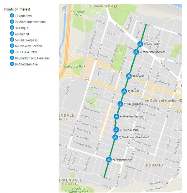
Proposed Greenway route with points of interest
York Boulevard is equipped with east- and westbound buffered bike lanes, making this an important network connection for the greenway. The eastbound bike lane leads directly downtown and cross the new Bay Street Cycle Track. The westbound lane leads to the Dundurn bike lanes and the bike lanes into Burlington.
The intersection of York Boulevard with Magill Street on the north and Pearl Street on the south is currently an uncontrolled crossing for pedestrians with a sidewalk across the grass median on York. Due to the median, vehicles on Pearl or Magill must turn right onto York and cannot drive across. As such, the median already serves as a traffic diverter for the greenway.
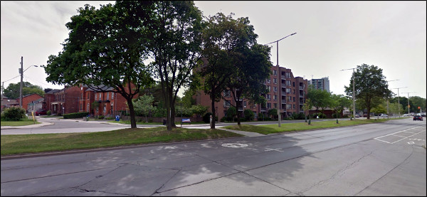
York boulevard, view from Pearl Street (Image Credit: Google Street View)
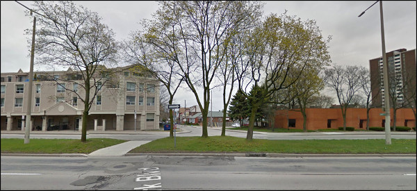
York boulevard, view from Magill Street (Image Credit: Google Street View)
As an uncontrolled crossing across a wide (three lanes on each side of the median), high-volume designated minor arterial street, this intersection is not currently walking- or cycling-friendly.
Legally, pedestrians or cyclists crossing here would have to wait for a gap large enough to allow motorists to yield, but realistically most drivers do not understand their responsibility to yield to pedestrians who are in the process of travelling across an uncontrolled crossing so this location is dangerous.
The most obvious solution here would be to install a pedestrian crossover (PXO) from Magill to the median and another PXO from Pearl to the median. Due to the high volume and speed of traffic on York, the PXO should include flashing overhead amber yield lights, highly visible pavement markings and abundant signage.
Another, more expensive option would be to install fully signalized, pedestrian-activated crosswalks from Magill to the median and from the median to Pearl.
On residential side streets, stop signs are often used at intersections in an attempt to deter automobile speeding and reduce the incidence of angle and side-impact collisions. The proliferation of stop signs is an aggravation for people driving cars, but it also acts as a major physical deterrent for people on bicycles, who must travel under their own power.
An often-cited article by physics professor Joel Fajans and transportation journal editor Melanie Curry calculates that the typical commuting rider produces around 100 watts of power and can travel around 20 km/h, but that their average speed declines by 40 percent on a street with a stop sign every 100 m. (Joel Fajans and Melanie Curry, "Why Bicyclists Hate Stop Signs", ACCESS #18, Spring 2001, p. 29)
There is a better alternative to stop signs for a neighbourhood greenway. The American National Association of City Transportation Officials (NACTA) recommends the use of mini-roundabouts on residential side streets. "Mini roundabouts and neighbourhood traffic circles lower speeds at minor intersection crossings and are an ideal treatment for uncontrolled intersections."
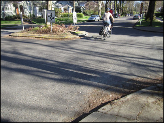
Cyclist navigating mini-roundabout (Image Credit: NACTA)
NACTA recommends a combination of pavement markings, signage and raised islands with plantings to maximize both the safety and attractiveness of these mini-roundabouts. Specifically:
Zebra crosswalks to clarify where pedestrians should cross and that they have priority
Sharrows to guide cyclists through the intersection
Yield signs at the curbside before the intersection and on the island
Shrubs or trees to beautify the roundabout and increase traffic calming effect
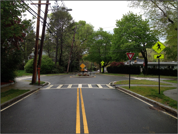
Mini-roundabout (Image Credit: NACTA)
I believe the minor residential intersections along Pearl and Kent may be excellent candidates for mini-roundabouts. These will dramatically increase the route's accessibility to cyclists of varying levels of fitness and skill, while effectively calming vehicle traffic, deterring cut-through driving and allowing full access for local vehicle traffic.
Combined with plantings, they will also make these streets more visually attractive, which will increase the greenway's appeal to local residents.
Here is a preliminary mock-up of how a mini-roundabout might fit on the greenway, in this case at Pearl and Florence:
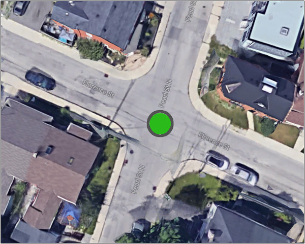
Mini-Roundabout at Florence and Pearl (Image Credit: Google Maps)
The design will force motorists to slow down to navigate around the roundabout without actually having to come to a stop. This achieves the goal of traffic calming without enraging motorists and inducing aggressive accelerating between stop signs. Likewise, it allows cyclists to navigate the intersection safely by slowing down but not having to stop, thus reducing the perception of wasted effort to start moving and accelerate after a complete stop.
Realistically, the vast majority of drivers and cyclists already effectively treat stop signs as yields, violating the law in a manner that seems justifiable to each individual. Drivers often accuse cyclists of routinely blowing through stop signs, which provokes the inevitable response that drivers also routinely blow through stop signs.
Instead of fighting human nature and preserving a design in which most users routinely break the law, it seems better to redesign the intersections in such a way as to legitimize what people are already doing and make it safe.
Another possible option would be to adopt the "Idaho Stop" rule in which cyclists can treat stop signs as yield signs. However, this would require the Provincial Government to change the Highway Traffic Act and the Ministry of Transportation has indicated that such a change is not under consideration at this time.
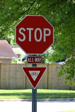
Proposed sign (Image Credit: Sean Burak)
The walking/cycling connection across King Street is already in place. Almost exactly a year ago, the City recently painted crosswalks and installed full traffic signals at King and Pearl, with the signals cycling in synchronization with the timed signals on the rest of King Street.
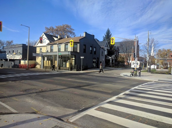
Fully signalized intersection at King and Pearl
Likewise, the City recently finished upgrading the intersection at Main and Pearl to full signalization, synchronized with the timed signals on Main Street. The new traffic signals have been activated and this connection across Main Street is now also in place.
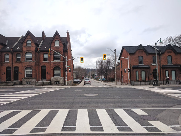
Fully signalized intersection at Main and Pearl
It's worth noting here that just six years ago, both King and Main were uncontrolled crossings at Pearl. In this way, Councillor Johnson will be continuing and building on the groundwork laid by his predecessor, Brian McHattie, who regarded this proposed greenway route as an important active transportation corridor to develop.
In October 2014, the new Pearl Street Bridge over the CP railway leading to Hunter GO Station officially opened. This was the culmination of several years of community advocacy and political effort to secure funding to replace the old bridge, which was no longer safe. The new bridge cost $770,000 to build (including the cost of demolishing the old bridge) and is designed to last 75 years.
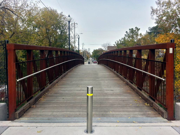
Pearl Street bridge
Crucially, the new Pearl Street Bridge is a walking- and biking-only connection across the railway, which means it also serves as a diverter for automobile traffic on Pearl that might otherwise try to use the street as a cut-through route.
The section of Pearl between Main Street and Tuckett Street is currently one-way southbound. The easiest solution here is simply to remove the one-way signs and allow the street to be two-way. To be sure, it is fairly narrow - but traffic volumes along this stretch are tiny and there is enough room for two cars to slow down and pass each other. Another option would be to install a northbound contraflow bike lane.
There is a pathway into H.A.A.A. Park right at the south end of Pearl where it turns into Tuckett Street. That pathway runs diagonally through the park and exits on the south side of the park at Charlton Avenue West and Kent Street. This is yet another existing physical barrier that forces automobile traffic to divert off the greenway route but allows continuous walking and cycling access.
In addition to the park, this location provides direct access to Ryerson Middle School the Hamilton Tennis Club. A very short trip west on Tuckett Street connects directly to the Locke Street South commercial district, including the Locke Branch of Hamilton Public Library.
South of Charlton, the greenway continues along Kent Street, which is a minor residential street with low traffic volumes but relatively high cycling, walking and jogging volumes.
Charlton Avenue is equipped with a westbound bike lane between James Street South and Dundurn Street South. Likewise, Herkimer Street is equipped with an eastbound bike lane between Dundurn and MacNab Street South. These parallel bike lanes are an important cycling connection between Kirkendall and Durand Neighbourhoods which were recently designed and installed in close cooperation with the respective neighbourhoods.
One of the first new pieces of active transportation infrastructure to be installed since the Public Works Department began to embrace a changing transportation design culture is the pedestrian-activated signalized crosswalk at Kent Street and Aberdeen Avenue, which was installed in 2012 after considerable neighbourhood advocacy and political effort.
This works well for pedestrians, who are able to push a button to engage the signalized crosswalk at the northwest and southwest corners, but it is less accessible to cyclists. Telling people to dismount and walk their bikes across an intersection is not an effective way to encourage cycling.
One option for this would be to add bike sensors in the road on Kent to activate the crosswalk signal, as the City has done at Studholme and Aberdeen (among various locations). Another option is to add crosswalk buttons that are accessible from a cyclist on the street.
The great thing about the Magill-Pearl-Kent corridor is that nearly all of the major pieces are already in place.
Perhaps most crucially, driving patterns already support its use as a neighbourhood greenway. There will not be a steep learning curve for drivers to start using alternate routes, because it is already not a through route due to the physical discontinuities at York, CP Rail and H.A.A.A. Park.
And with Ryerson School and the park right on the route, Pearl and Kent are already significant pedestrian corridors with high levels of foot traffic. (After the crosswalk was installed at Aberdeen and Kent, pedestrian traffic across this intersection more than tripled.)
This would be a fantastic way to showcase a new approach to active transportation infrastructure that is gentle, integrates nicely into an existing neighbourhood, balances the needs of different transportation modes, and provides significant improvements for walking, cycling and local quality of life without having to inconvenience any set of street users.
It is a political "win-win" with a very reasonable cost to implement.
By Wentworth (registered) | Posted March 22, 2018 at 08:47:37
Would be a nice west end bookend for the Red Hill Valley Trail (Mud & Paramount to Nash & Van Wagners)
By Pxtl (registered) - website | Posted March 22, 2018 at 09:07:33
Related, I put in two requests for a similar greenway that many cyclists already use - Head/Victoria Park/Napier:
#2 "Cycling Improvements In Strathcona" which if you read the details, focuses on the popular Head/Napier route.
#25 "Push-button Crossing on Queen/Napier".
Comment edited by Pxtl on 2018-03-22 09:35:21
By Pxtl (registered) - website | Posted March 22, 2018 at 09:13:01
On the Idaho Stop, it really feels like so many of these interventions like blocking neighborhoods are unnecessary when stop signs do the job pretty well... but stop signs impede cycling, the Idaho Stop really feels like the best solution.
Even without going full Idaho Stop, I wish the ministry would support a simple "All-way stop where cyclists are exempt" special signage to support greenways. Then the city could identify specific side-roads as being greenways, implement cyclist-exempt all-way-stops along the route, and create a cycling-and-pedestrian friendly route with nothing but road signs. Obviously that would be a half-measure, but it would make so many greenways (like my Napier route) into easy low-hanging-fruit.
By Borrelli (registered) | Posted March 22, 2018 at 09:15:22
Sweet idea--did City Staff give you any idea of the estimated cost for the whole route?
By KevinLove (registered) | Posted March 22, 2018 at 09:56:01 in reply to Comment 122698
I disagree. In my opinion, the best solution is to systematically remove rat-running "cut-through" motor vehicle traffic from ALL residential neighbourhoods. This was what done in The Netherlands. See this blog post and video for a description and example of how this is done:
http://www.aviewfromthecyclepath.com/201...
Key quote from the description: "Residential streets in The Netherlands rarely work as through roads for cars, even if they were originally designed to do so."
As a result, it is very rare for a cyclist to encounter a stop sign in The Netherlands. There is only one in the video, at the 7:20 mark.
Comment edited by KevinLove on 2018-03-22 09:56:38
By KevinLove (registered) | Posted March 22, 2018 at 10:18:13 in reply to Comment 122702
I too rather like roundabouts. Here is a video showing best practices for roundabouts.
Interestingly enough, the mini-roundabout is almost unknown in The Netherlands. This is because rat-running "cut-through" car driving has been eliminated from almost every residential neighbourhood. This is also why it is rare for a cyclist to encounter a stop sign.
Comment edited by KevinLove on 2018-03-22 10:19:25
By KevinLove (registered) | Posted March 22, 2018 at 10:46:14
The article Ryan referred to, "Why Bicyclists Hate Stop Signs," may be found here:
By JasonL (registered) | Posted March 22, 2018 at 11:35:22 in reply to Comment 122697
I voted for these, as well as the Greenway above. All 3 would be massive wins for the entire west side of downtown. Well done!
By JasonL (registered) | Posted March 22, 2018 at 11:37:09 in reply to Comment 122698
I certainly prefer the Idaho stop to round-abouts here in Hamilton. Maybe in Europe it's different, but we all know that without stop control for car drivers here, it'll be mass mayhem. Our high speed car culture is awful. Our design standards would provide a roundabout too small and drivers would learn to keep full speed while whizzing around the slight bend. No thx
By mdrejhon (registered) - website | Posted March 22, 2018 at 15:31:54
Ryan,
This is an excellent idea, and if I was living in Ward 1, I would be giving my vote for this already as one of the favourites.
I now ride my bike more often than drive during my work commutes even during this winter, as part of my first-mile commute (to GO) -- it gives me a three kilometer exercise everyday.
I live in Ward 3 myself, and we need more viable north-south cycleways. The new Bay cycle track and the existing Hughson Bike Route are my current favourites but we need more further east and west.
Comment edited by mdrejhon on 2018-03-22 15:34:37
By KevinLove (registered) | Posted March 22, 2018 at 15:37:48
One problem with this proposed greenway is that it is not in the City of Hamilton's Cycling Master Plan. However, Locke Street is, as may be seen in the above link at Appendix A, item 12. Locke from Main to Aberdeen is scheduled for bike lanes.
Locke Street is a busy shopping, cafe and commercial street, like Jodenbreestraat in Amsterdam. Isn't that video what Locke Street should look like?
This definitely not an either/or issue. We can have a greenway as Ryan proposes and also transform Locke Street per the existing Cycling Master Plan.
Comment edited by KevinLove on 2018-03-22 15:39:30
You must be logged in to comment.
There are no upcoming events right now.
Why not post one?