An important but problematic cycling connection in Hamilton could be fixed easily with wayfaring signage at each end and a curb cut.
By Kevin Love
Published January 26, 2015
The Dutch word ontvlechting translates into English as "unravelling" or "unbundling." It refers to one specific tool in the toolbox for implementing the Dutch traffic safety methodology of Duurzaam Veilig or Sustainable Safety.
In a traffic safety context, ontvlechting means separating the routes taken by people to travel from the routes taken by motor vehicles to travel. This results in reducing the dangerous conflict that occurs with the movement of people and the movement of motor vehicles in the same space.
How does ontvlechting work in The Netherlands? The way that ontvlechting is typically implemented in The Netherlands is through a combination of:
1. Local access to residential neighbourhoods. Almost all residential streets in The Netherlands do not allow cut-through car drivers. Through traffic is only allowed to cyclists and pedestrians.
2. Car-free main cycle routes. These are no longer simply cycle paths that parallel car routes. In The Netherlands, such cycle paths are now considered old and inferior.
Note how even the "old, inferior" infrastructure would be a big improvement on Hamilton!
The Dutch goal is to take a step up from existing cycle paths along car roads that only separate people from motor vehicle traffic on a road basis. Instead, the entire cycle route is unbundled from car traffic. This provides for main cycle routes that go directly from A to B in a safe and pleasant environment.
How could ontvlechting work in Hamilton? Several other proposals have been made for main cycle routes that would separate people from motor vehicle traffic on a route level.
I have a few ideas myself along these lines. But since I am writing an article, not a book, I'll only look at one specific neighbourhood local access that I use quite frequently: the connection from Jackson Street West to Dundurn Street South.
Notice the following:
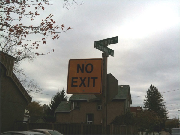
Wayfaring gives false information. Anyone travelling westbound on Jackson Street will confront this sign at Poulette. This is, of course, completely false information. As we are about to see, there most certainly is an exit to Dundurn Street.

No Exit sign on Jackson at Poulette
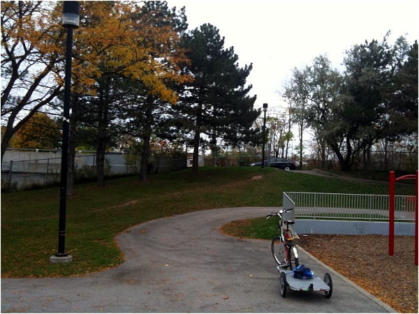
Here is the exit to Dundurn:

Exit from Jackson to Dundurn
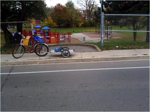
But when we get to the Dundurn Street bike lane, there is another serious problem: no curb ramp from the path onto Dundurn.

No curb ramp on Dundurn access to Jackson
That is quite a formidable curb! Since I am a rather large and healthy man, I can lift my bike and bike trailer over the curb. But even for me, when the trailer is loaded with groceries, this is very difficult, inconvenient and just plain nuisance.
Not everyone is a large and healthy man. For them, a curb like this can mean the difference between a route that is useable and one that is not.
Notice also the total lack of wayfaring signage. From Dundurn Street, there is no way of knowing that this is the connection to Jackson.
These problems are all easily and cheaply fixable. All we need is wayfaring signage at each end and a curb cut.
Dutch cities used to have this sort of neglect of cheap and easy ways to fix cycling problems. They changed. We can too.
By AnjoMan (registered) | Posted January 26, 2015 at 13:49:02
Wow. With a little bit of finessing, Jackson could be a cycling route all the way to Wellington; all it would take is some cycling signals to cross a few roads and some separation allowing it to cut through City hall. Can you imagine if council would ever approve building a cycling route on city hall property?
By KevinLove (registered) | Posted January 26, 2015 at 13:57:20 in reply to Comment 108419
We can't even get decent parking at City Hall. Instead we get racks that are not bolted down securely, will not accommodate a 28" wheel and have snow pushed into them all winter long to render them useless.
There are also bike lockers that are so small that my 62 cm frame bike will not fit into them. Yes, I'm a big guy, but public facilities should accommodate everyone.
Comment edited by KevinLove on 2015-01-26 13:59:48
By Pxtl (registered) - website | Posted January 26, 2015 at 20:39:19
I keep coming back to Napier Street. It would take only a little massaging to make this a great East/West route across the north side. Some cyclist-exemptions from all-way stops, a crossing at Queen, some bike signage at the Federal building, and (the only hard part but the thing that should have been done years ago) a 2-way conversion of Bay Street.
By John Neary (registered) | Posted January 26, 2015 at 23:04:32 in reply to Comment 108444
Don't forget a crossing at Head/Hunt and Dundurn!
The crowning touch would be a cycling bridge from Hunt St (behind the cathedral) over the 403 on-ramp, meeting the existing 403 bridge on the Westdale side. Not gonna happen, though.
By Pxtl (registered) - website | Posted January 28, 2015 at 02:06:45 in reply to Comment 108459
A bridge would be overkill.
A yield sign or a "stop for pedestrians" or something would be plenty.
By KevinLove (registered) | Posted January 28, 2015 at 01:45:14
One thing that would be quite easy is a connection from Hunt to Kay Drage Park. This would allow a bicycle route under the 403 using the existing road to Kay Drage Park to connect to the Desjardins/Waterfront Trail.
And if we want to get really ambitious, then construct a causeway from where the Waterfront Trail ends across to the spit of land jutting out from the Burlington side. Then a cycle route through the cemetery to Spring Gardens Road in Burlington.
This would not only create a Main Cycle Route fully separated from car traffic, but it would be a much shorter route to Burlington than the car route using York Blvd/Plains Road. Fast, direct, easy and convenient... that is what cycle routes should be like to take us from A to B.
You must be logged in to comment.
There are no upcoming events right now.
Why not post one?