Barton-Tiffany is a good place to start practising some of these things which do not preclude or foreclose development but prepare for it.
By Shawn Selway
Published December 11, 2013
Since Barton-Tiffany is returning to the public agenda after a long hiatus, it may be of interest to catch up on what has been happening over there in Death Valley since the wrecking crews went through in the fall of 2011.

Left, garden soil. Centre and right, recent fill at Barton-Tiffany: sand and silt, little or no organic material.
No, not those ones. The consultant trials in Barton-Tiffany, sure to produce some outstanding performances.
Back in September, the custodians of the Future Fund and Councillor Sam Merulla were disputing the wisdom of pulling another seven and a half million out of the Fund for purposes of aiding and abetting Board of Education vandalism in the lower city.
Merulla objected to the intemperate language of Councillor Judi Partridge, who, according to the Spectator, complained that it was wrong for Council to regard the Fund as something they could "just pillage whenever there seems to be a whim or a need."
Merulla insisted that the proposed withdrawal was to be a loan only. In his words, "bridge financing." The argument is that some of the Pan Am money taken as an outright grant from the Fund was used to buy land in the Barton-Tiffany area for the stadium that never was, and that the eventual sale of this land would recoup at least the eight million which the City paid in 2009, which would then be returned to the Fund.
The obvious questions would seem to be: Is the councillor's estimate of the value of Barton-Tiffany lands correct? And if so, why is the city not selling today? Is appreciation of the property expected? How would that happen?
In the event, Council chose to backhand the Board of Ed and nix a co-operative venture on the Scott Park site, a decision which produced new complications, culminating in the Board's decision to replace the very large Scott Park High School with a surface parking lot.
Around the same time, Council did sell off a portion of its West Harbour holdings, a six acre triangular plot on the north side of Stuart at Queen. The buyer was, oddly enough, CN; in other words the City is expanding the rail yard, which is interesting, as is the explanation. Also afoot is the long-awaited urban design study for the area, which is going the Community Liaison Committee route and will kick off in early December.
The staff report on Declaration of Surplus and Sale of 241 Stuart Street to Canadian National Railway Company recommends the transaction because it will further the City's long term strategic goal of obtaining all-day GO rail service.
The City was approached originally through GO/Metrolinx in regard to the purchase of the property, on behalf of CNR, in regard to the operational needs of the James Street North GO station. CNR's schedule for track and associated works requires the relocation of the existing buildings as soon as possible. These buildings must be moved in order to accommodate the new track necessary to service the GO station at James Street North. An external appraisal prepared for Metrolinx determined the fair market value of the subject property at$1,320,000 ($200,000/acre). City Real Estate staff have reviewed the appraisal report and concur with the value opinion. The offer to purchase from CNR to the City is at a price that reflects the appraised market value.
The sale of the subject property will facilitate the development of the James Street North GO rail station by Metrolinx by providing additional land to CNR to replace lands it will be required to give up within the Stuart Street Rail Yard, in order to accommodate the new GO station. Monies from the sale will be applied to find replacement premises for the Roads Operations Division of Public Works, which will have its snow storage facility displaced as a result of the sale of 241 Stuart Street.
I don't know if this deal has now been completed or not.
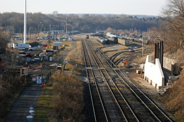
Stuart Street yard from MacNab bridge, looking west. The new Bay Street bridge under construction in the foreground. Commuter parking for the new James GO station is to extend along the south side of the track.
Meanwhile construction continues on the new bridge at Bay Street, with completion now expected in June, about six months later than the original schedule. Presumably this structure will include a tower to house the elevator or stair which Metrolinx plans for commuters moving between MacNab and the trains below the James GO station.
Public consultation on Barton-Tiffany begins with an information session to be held at LIUNA on Dec. 4, with others to be held in the first half of 2014. The Barton-Tiffany exercise is being coupled with a similar show-and-tell for the new GO station forecourt at James and Murray, as well as something vague to do with Barton Street from James to Ottawa, and Kenilworth from Barton to Main.
For the benefit of readers who may have come to town after the acrimony subsided, some background is in order. Longtime observers familiar with the history may skip the next few paragraphs, which will only irritate them all over again.
The City bought the Rheem property in October of 2009, after they had put the West Harbour site in the Pan Am bid book, voted the 50 million for a stadium/velodrome, and were about to get the Games Committee choice announced a week or two later, on Nov. 6, 2009.
It is true that then-Mayor Fred Eisenberger said negotiations had begun earlier, and that the land was "strategic to the waterfront development."
The "strategic" bit is certainly correct; but it was understood that Fred was saying this because, during preparation of the bid book, the public was told that the West Harbour site was just a placeholder in the book, and that there would be a public debate on stadium location if Hamilton were awarded the games.
Buying the land would seem in itself to foreclose the debate, which would be impolitic, hence the "well, we want it, games or not" line. Presumably the deal was closed before the Pan Am announcement was made in order to keep the price down, although the City's desire to put a stadium there was not exactly a secret.
Mayor Fred, the Spec and a strong local lobby had already decided on West Harbour years earlier at the time of the Commonwealth Games bid, stuck to their guns ever after, and were reinforced by a genuinely populist marketing campaign in favour of the site.
Unfortunately, they forgot to secure Mr. Young, and after a couple of false starts, Council and the Cats ran out of time and fell back to the initial location.
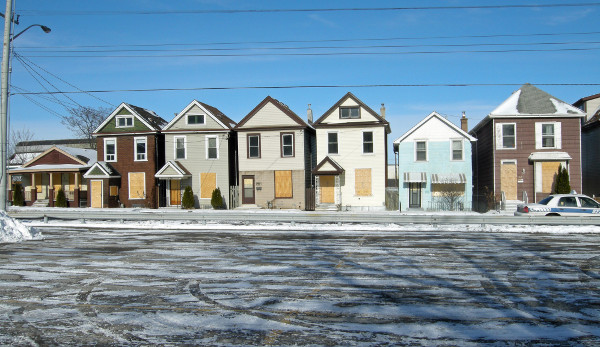
Houses on the north side of Barton at Caroline. Just visible at the left is the roofline of a large clerestory building, also demolished.
In the fall of 2011, the City began to clear their Barton-Tiffany property, removing thirteen houses from Barton and Tiffany streets, and the premises of seven businesses including relatively new buildings housing a gas station/variety store and an auto-repair shop.
An older industrial building in the centre of the Caroline-Hess block, last serving as the home of B&M Metal Recycling, was also taken down. In January of 2012 the large structure on the north side of Barton between Tiffany and Caroline, formerly occupied by Rheem, was demolished. The pad remains, along with concrete walls on Tiffany and Barton, which are shoring the slope.
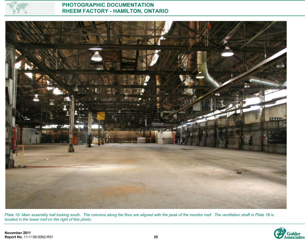
Prior to demolition, a consulting firm was engaged to make a photographic record of the building, inside and out. Perusal of this document, obtained from the City under a Freedom of Information request, is a disheartening experience.
The images show a very large clear span volume, essentially a shell of steel and brick, all easily inspectable and therefore readily adaptable to other uses.
In addition to the railyard, three manufacturers remain active in the precinct, west of Queen. These are the AVL Group of companies, comprised of AVL Manufacturing, Onepower, and Eco-H.
AVL's well-kept buildings and grounds are separated from the city lands by the Hess-Queen block, an overgrown mystery wrapped in a riddle, whose soil condition no one seems to know, and which is an impediment to development in Barton-Tiffany which the City will eventually have to confront. The apparent reluctance to do so is a puzzle in itself, since that property must be a serious drag on the value of what we own across the street.
Once the stadium had been shifted back to its 1928 midtown site, the "preferred alternative" issuing from the secondary plan process, which had been arbitrarily overruled by the City, came back into force.
Under Setting Sail, as the secondary plan is called, the Barton-Tiffany precinct was to become housing. However, this did not sit well with CN, whose marshaling yard abuts the area.
According to their counsel in discussions at Ontario Municipal Board proceedings, CN believes that new residents in the vicinity of railyards are very likely to make attempts to have the yard closed or moved.
These attempts invariably fail, because rail yards are federally protected infrastructure - but not until CN has been obliged to send in lots of high priced expertise to fight the case. Preemption is cheaper, and accordingly CN objected to the Board about Hamilton's plan to develop Barton-Tiffany for residential purposes from Barton all the way north to Stuart, the boundary of the rail yard.
CN's case was paradoxical. Although rail operations are overseen by the federal department of transport, and only the feds, CN proposed that for present purposes its yard should be defined as a Class III Industrial Facility under the typology used by the Ontario Ministry of the Environment, and subject to its regulations.
Class III facilities are so loud or obnoxious that the MOE requires a minimal separation zone of 300 metres between such operations and residential uses. CN suggested that the City treat the yard as if it came under Provincial jurisdiction, and the Class III designation was eventually inscribed in the secondary plan.
Recognizing the City's aspirations for the West Harbour, CN offered a compromise, of a 150 metre exclusion zone. However, if the City rejected the offer and went into a full OMB hearing, then CN would insist on asking the Board for the full 300 metre separation, effectively sterilizing the entire area from Barton Street north.
Council weighed the risks and decided to accept the compromise. But there was a hitch. North End Neighbours, which, along with Central and Beasley, had been a stakeholder in the long drawn out Setting Sail studies, did not like the deal, preferring greater residential intensification in the lower city.
Also unhappy was the developer who had assembled a parcel of land on the slope west of Bay street between Barton and Stuart, and who was about to see his land zoned low density and his projected medium rise building vanish like a pleasant dream.
NEN and White Star developments turned on the City and pushed the OMB process a step further - not to a full hearing, which NEN could not afford, but to mediation, from which CN and White Star emerged with the biggest gains.
The City accepted CN's compromise offer, of a 150 metre separation zone. White Star, after performing noise and vibration studies to the satisfaction of CN, and offering a building design which met CN concerns, was given site-specific zoning to allow medium density residential.
White Star thus has permission to build an eight story building on the westward facing slope that descends from Bay to Tiffany on the shoulder of the Bay Street bluff, conditional on the noise abatement measures of the structure meeting the standard agreed with CN and the planning department.
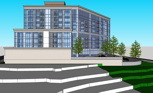
The north elevation of White Star's proposal for a building on the west side of Bay, 2012 version. The north and west sides are entirely glass, to buffer noise from the railyard without losing the views.
At the end of November, White Star announced a residential condominium development, to be accompanied by commercial buildings on the northern part of its holdings. The rendering published with the announcement looks nothing like the atrium-backed structure presented at the OMB in 2012.
Considerations of wind loading or solar gain at an eight storey west-facing glass wall may have led to changes. The current iteration is a dowdy but perhaps smarter building - or maybe it is just cheaper.
In a final twist, architect Bill Curran and local notables Bob and Maggie Carr, who had become alarmed by rumours of Big Box retail being allowed into Barton-Tiffany, began meeting in the spring of 2012 with mostly like-minded citizens and put together a redevelopment plan on a scale not seen since the glory days of federally assisted "urban renewal", when Hamilton condemned and demolished 250 buildings in the city centre and cleared 400 buildings, mostly houses, from the North End.
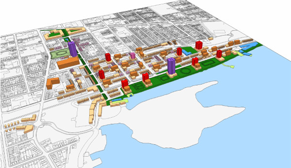
The Curran plan for the rail yard and beyond. Omitted from this expansive plan, which overflows Barton-Tiffany for several blocks in all directions, is Mr. Curran's proposal that the low density public housing survey bounded by Strachan, Ferrie, James and MacNab in the North End be replaced with a high density development of some sort.
The Carr/Curran "vision" was presented to planning committee councillors in the late summer of 2012 and was greeted politely if not enthusiastically.
In remarks accompanying the presentation and signed by Bob Carr and Kathy Renwald, it was explained that this plan would yield 9,000 residential units on complete build out.
The presenters recommended interim uses while waiting for some of this development to occur, but with the proviso that there be lots of notice and signage that these uses were only temporary, lest people become attached to the open space. They also wanted the City to postpone any urban design study until CN's views on moving the yard were known. CN promptly reiterated its utter lack of interest in re-locating.
Not discussed during this episode was the dearth of development pressure adequate to induce the investment required for any of this; nor the stock of vacant lots at the city centre, which continues to increase; nor the residential capacity of large empty buildings like the Connaught and the former Westinghouse office towers which we might wish to see re-used.
There was a lull, and then a steady parade of trucks carrying waste soils and construction debris began to proceed to the city-owned portion of Barton-Tiffany.
First, in December of 2012, came soil from the Mac Med excavation at Main and Bay, which was placed on the concrete pad at the former Rheem building. This dirt is just visiting and is to return to its source near the end of the Mac project.
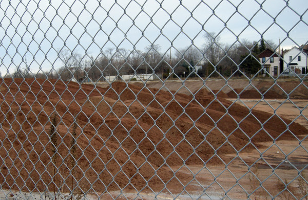
Just visiting. Mac dirt parked on the former Rheem site.
Next came a long series of deposits from donors who may or may not be known to the City.
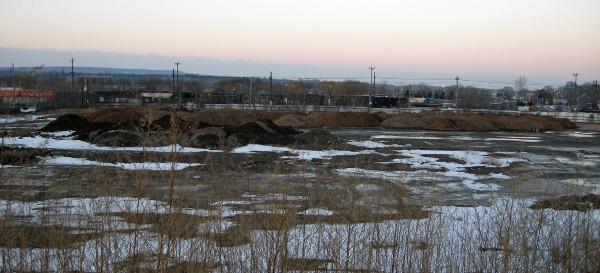
January 2013. Looking north from Barton on the block between Caroline and Hess.
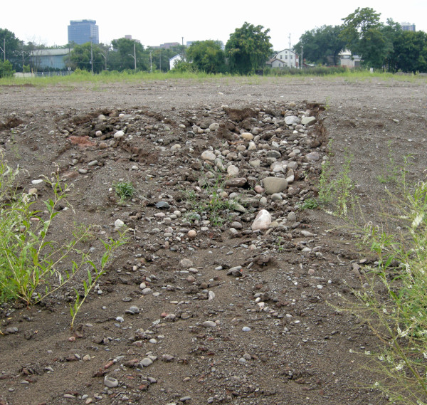
Looking south. The January material was supplemented and eventually the whole burden was spread to a depth of about a metre over the northern half of the block. By summer the rain had begun to cut channels revealing the large quantity of beach stone in the fill.
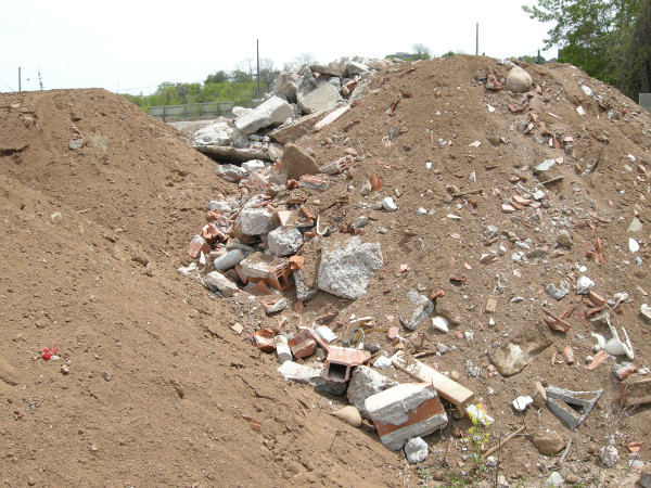
In May came this donation of construction rubble and waste soil. Looking south-west, from within the site.
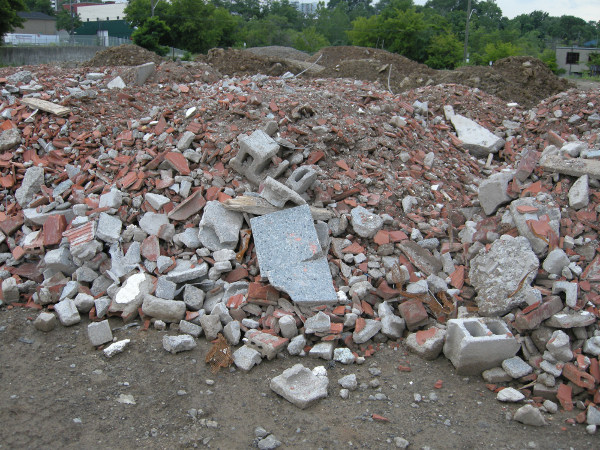
After the May load was bulldozed level, it was followed in July with an even larger bequest, shown above.
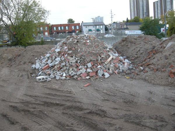
October. After previous installments were levelled, another layer was brought in. Looking south toward Barton.
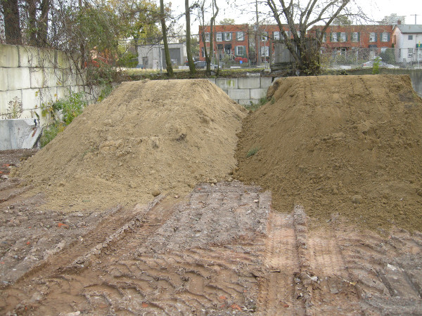
And some icing. November.
Inquiries to the councillor, who then spoke to Public Works, elicited the response that the fill was being placed in order to level the site, for safety reasons. Whatever one might think of this operation, that is a whole lot of dirt, which is not going anywhere else for free.
A number of questions arise. What is the condition of the soil beneath the fill? Is it contaminated, and if so to what depth? Given that this low ground is quite near lake level, are any contaminants moving through the soil into the harbour?
If remediation is required, the new overburden will have to be removed. Who pays to take up what the City has allowed to be laid down here? Where will it be placed when it is moved? Will it be pushed about the site? What about the rocks and the masonry elements?
This property, even discounting for the presence of the railyard, is a prime piece of waterfront land - one from which you can easily see the cranes tending the newly rising apartment buildings in Aldershot.
As is often pointed out, the residents of those buildings are looking at the steel mills- that is, at smoke stacks and coal piles. Dwellers in Barton-Tiffany would be seeing, from anywhere above the ground floor, nothing but sky and trees, with maybe a sail or two for decoration.
Since the Urban Design study for this area is about to begin, presumably something will be built there in two years or ten. But meanwhile, what? We see once again that we have no interim measures for brownfields.
While the City plants the medians on York Boulevard, at the entrances to Bayfront Park and to Westdale, and elsewhere, all of that beautification is cancelled for any driver who gets onto Barton between Locke and Bay. What they see there is an advertisement for civic indifference and inertia, acres and acres of it.
Will we really have to look at Barton-Tiffany in it's present state, part barren dirt, part concrete pad, for the indefinite future? What might occur here pending development, bearing in mind that this is a city-owned property? To consider that question, it may be helpful to step back and look at the larger natural context.
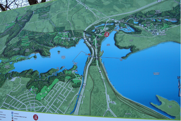
The bigger picture. This sign is at the entrance to the Rock Gardens. Barton-Tiffany is just off the map at the lower right. Not highlighted is the wooded strip that runs along the harbour side of Burlington Heights to Queen. Obviously our best course would be to extend the wooded shoreline eastward through Barton-Tiffany and the rail lands, but this is unlikely to win wide acceptance until 2150 or so - assuming the land is still above water at that time.
Although most of the architectural programs for Barton-Tiffany ignore the fact, BT is in a rather deep valley. The slope from Bay to Tiffany is a very sharp drop. That from Queen up to Locke is more gradual. Looking west across the valley from Bay and Barton, one feels that the top of the opposite slope, at Barton and Locke, is about level with where one is standing.
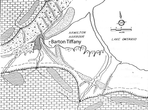
The Iroquois Bar is the dotted area that runs across the lower city. The pencil-shaded area indicates the pre-railroad outlet by which Cootes Paradise drained into the Harbour. Barton-Tiffany lies in the cove between two lobes of the Bar. Source: Mark Sproule-Jones, Hamilton and its Harbour.
The land-forms schematic above shows that the two hilltops are high points of two lobes of the Iroquois sand and gravel bar that curves across the lower city from the Red Hill break to Aldershot and beyond.
Between the lobes lies the valley, whose mouth is at the shore and which ascends gradually from there all the way south through Central Park to York street. Bay Street runs down the edge of the eastern lobe of the bar to the water.
(For detail on the history and geography of the western end of the bar, see John Terpstra's 2002 psychogeographic romance, Falling into Place. The Heights are currently the subject of a study meant to result in a management plan for the area, the first of six such area studies proposed within the Cootes to Escarpment Park project area.
Both the Heights and the Barton-Tiffany valley (Tiffany was an early mayor and land speculator) have been very busy places for two hundred years, with the valley passing from marsh and garbage dump to track, yard and shops for the Great Western; foundries and shops including those of Stelco and Hamilton Bridge and Tool, Rheem, and briefly Sawyer Massey; and now back to dump.
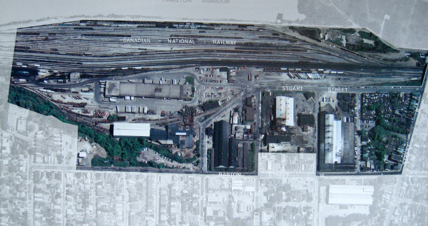
Barton-Tiffany in 1986. The blocks from Tiffany in the east to Queen in the west have been cleared. Source: Industrial Land Use in Hamilton Wentworth, City of Hamilton, 1986.
The result of the latest large intervention in the landscape is a metre-thick mantle of dirt containing rocks, bricks, chunks of concrete and terra cotta blocks, etcetera, laid over and alongside a bed of concrete and clay, which may or may not be contaminated with industrial waste.
The lowest and most basic use which could be made of this patch is simply to convert the dead dirt into loam (equal parts of sand, silt and clay) and then grow some good soil in it i.e. start a microbe farm, followed by plantings.
A soil's fertility depends upon its structure and its biota - that is, the interdependent microbes, fungi and invertebrate life that inhabit the upper level and enter into symbiotic relationships with plant roots and leaves. Its structure determines how, or whether plants are able to acquire water and nutrients from it; its biota determine what those nutrients are.
Whatever the character and condition of the soils in the stratum that was uppermost when the City had finished clearing the site, that stratum is now inaccessible for short term phyto-remediation efforts.
The condition of the fill seems rather poor, which is both a problem and an opportunity. On the one hand, the range of what is growable in this soil is probably quite limited. On the other hand, this dirt is an underpopulated neutral zone, which can be biased by adding structural elements and inoculating with the preferred biota, depending on what one wants to plant here. (For basic information on the soil food web, see Jeff Lowenfels and Wayne Lewis, Teaming with Microbes, 2006. For the rudiments of phytoremediation and many case histories see Leila Darwish, ed. Earth Repair, 2013)
We have a lot of similar places, though few as blank as Barton-Tiffany. It would be very helpful for neighbourhood property values, and for our much-lamented image in the wider world, if we started learning how to provide safe public access and a variety of interim measures at these sites, on our way to the higher uses, which are a very long time coming.
Barton-Tiffany is a good place to start practising some of these things which do not preclude or foreclose development but prepare for it. Successful interim measures could be extended to other sites, like the one below, which has been sitting empty for at least twenty five years, and was recently cleared of most of its vegetation -- probably to discourage the homeless from taking up residence there.
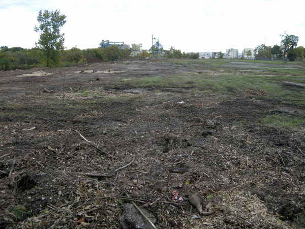
Looking north from Ferrie between Wellington and Victoria. This acreage has been idle and fenced for at least twenty five years.
We will soon to be faced with the serious challenge of reintegrating some portion of the Stelco lands into the public realm. Do we really want that vast expanse, shown below, to sit like a version of the barren lot above, only a hundred times larger, for thirty or forty years?
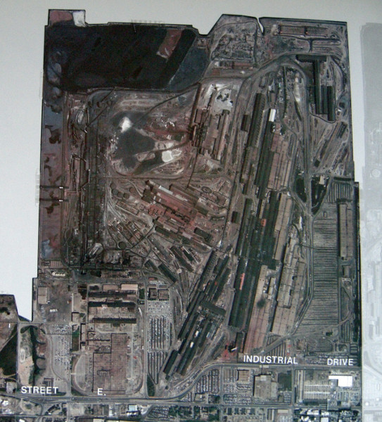
Stelco lands in Hamilton Harbour, 1986. Source: Industrial Land Use in Hamilton-Wentworth, City of Hamilton, 1986.
Or would we prefer something like this..?
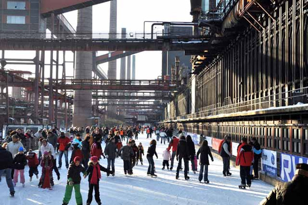
Family time among the coke ovens. The deactivated Zollverein coal mine and coking plant in the Ruhr Valley is very much in use as a culture and recreation centre and tourist attraction on the European Route of Industry. Image Credit: Manfred Vollmer.
By Noted (anonymous) | Posted December 11, 2013 at 19:01:40
"...an exceptional industrial monument..."
http://whc.unesco.org/pg.cfm?cid=31&id_site=975
http://www.worldheritagesite.org/sites/zollverein.html
http://www.germany.travel/en/towns-cities-culture/unesco-world-heritage/zollverein-coal-mine-industrial-complex-in-essen.html
By Ted Mitchell (registered) | Posted December 11, 2013 at 21:14:09
I think the area would get more attention if it's made to sound sexier.
e.g. Where is Tiffany Barton, the Lakeport Honey?
It sells everything else...
By Bill (registered) | Posted December 13, 2013 at 03:00:23
Shawn, Thank you very much for taking time and effort to bring such rigor and clarity to the otherwise muddled public conversations surrounding the so called West Harbour waterfront development.
It is so easy to draw up seductive mega-plans and rendering on computers, without having to factor the multiple layers of reality underneath, or the land's historical and geographical context. It is such simplistic visions that end up misdirecting public conversations in our city.
The meter thick new addition of questionable fill on top of the preexisting contamination underneath, (which may be already flowing towards the lake), is very disturbing news. These lands have become a showcase for our city's total lack of planning vision and competence in property development.
Given the city's move to continue adding questionable new fill, it appears that these lands are destined to end up with some extra-large, stucco faced commercial box stores, built on large concrete pads, connected with asphalt roads and parking as seen at the New Centre Mall. And Hamilton may end up getting international fame for giving an entirely new meaning to 'Breakfast at Tiffany's' as the city tries to humanize such toxic developments with quaint patio restaurants, like the ones on Upper James and on East Mountain.
Hopefully those hyping the waterfront development slow down to grasp the complexities you have presented here.
By tl;dr (anonymous) | Posted December 18, 2013 at 00:01:27
This article needed more tables and references to Portland, biking, "complete streets" and the like.
WOULD NOT RECOMMEND
F++
You must be logged in to comment.
There are no upcoming events right now.
Why not post one?