The EcoPark System is one of the largest coordinated urban park systems in Canada and deserves more public awareness.
By Steven Watts
Published October 22, 2013
The goal of the Dundas EcoPark Campaign is to establish a 2,000 hectare (4,950 acre) conservation area surrounding Cootes Paradise. Remaining privately owned land must be secured and converted it into a protected area.

Image Credit: Cootes to Escarpment
The EcoPark System provides the only continuous habitat connection from Lake Ontario to the Niagara Escarpment not broken by a series 400 highway. This piece of green-space is one of the largest coordinated urban park systems in Canada and deserves more public awareness.
Take a look at the map below. The Dundas EcoPark, which is shown in green, is already 75 percent publicly owned. Upon completion, the EcoPark will encompass an enormous region of protected green space between the Niagara Escarpment and the Hamilton Harbour.

Dundas EcoPark Map
By securing the remaining privately owned land, the project will ensure this diverse and valuable ecosystem can be sustained. The EcoPark area contains more than 1,500 plant and animal species, including nearly 40 percent of all plant species in Canada.
The EcoPark is also home to more than 50 species that are considered at risk, including several species of turtles and birds. You can view a detailed list of species at risk within the area.
The Dundas EcoPark will ultimately increase the ecological value of the area and provide a larger space for species to thrive.
By 2031, the region's population is estimated to reach 1.4 million - an increase of 37 percent. You can imagine the implications of urban sprawl and population booms on unprotected green space. In response, the EcoPark will provide a sustainable and accessible place for the community to enjoy the beauty of a natural ecosystem.
With such close proximity to densely populated cities, this area of protected land ensures that city-dwellers can continue to experience nature in their own neighbourhood.
According to the American Psychological Association (APA), immersing oneself in nature can have significant impacts on mental and physical states. An APA study suggests that living and working in an urban environment can produce stress, agitation, and focus issues.
One of the main research questions of the study considered the impact that nature could have on the human condition. Researchers exposed urban-working participants to a small amount of green space and monitored the effects. Participants felt that exposure to nature provided a sense of mental clarity and relaxation in comparison to the bustling urban environment - a valuable consideration when thinking about the EcoPark campaign.
The EcoPark can provide invaluable green space and potentially contribute to a healthier, more clear-headed, community. This area can serve to break up the rigidity of urban life and allow city-dwellers to connect with nature.
This quick introduction to the Dundas EcoPark Campaign is meant to outline details about the project and highlight the value of the area. In further articles I will expand upon the importance of this green space for eco-tourism, local identity, community enjoyment, and environmental education.
The EcoPark project would not be possible without the many stakeholders working diligently to complete this project. Take a look at the list of those involved and learn more about how they are contributing.
List of involved parties:
First published on The Starfish
By seancb (registered) - website | Posted October 22, 2013 at 10:36:07
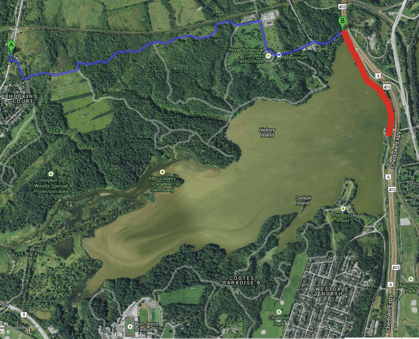
Very cool.. somewhat related, I have long had a dream that the trail from the arboretum to york road be made an official multi-use trail (blue line on map)... with the really big dream that we have a pedestrian/bike bridge at the fish gate under the high level bridge to connect the waterfront trail to the RBG and beyond (in red)...
Comment edited by seancb on 2013-10-22 10:36:48
By highwater (registered) | Posted October 22, 2013 at 10:51:33 in reply to Comment 93515
Love this. Sadly can't see the RBG allowing a multi-use trail through their lands, but we can dream.
By seancb (registered) - website | Posted October 22, 2013 at 11:12:35 in reply to Comment 93516
Perhaps if they were more inclusive they'd have broader membership supporting their operating costs. People ride (illegally) on their trails already, because the city doesn't provide a safe alternative to york road. This could be a fantastic way to connect dundas to york blvd and also to the harbour if only the RBG and city could work together and muster a smidgen of vision
By highwater (registered) | Posted October 22, 2013 at 13:07:27 in reply to Comment 93519
You wouldn't believe the pushback from local residents and naturalists at the prospect of UNpaved pathways in Churchill Park (rbg owned land), something the rbg itself actually supported. The notion of a paved pathway through rbg lands would make people apoplectic, and likely cost them more members than they would gain, but hey, shoot head of conservation Tys Thysmeyer an email and see what he has to say. Can't hurt to ask.
By seancb (registered) - website | Posted October 22, 2013 at 14:07:19 in reply to Comment 93529
Well it doesn't have to be paved, it just has to allow for multiple modes just like the escarpment rail trails which work perfectly fine with multiple users.
My big dream is still the bridge. It would be a fantastic link to help people explore cootes and RBG without having to drive halfway (or all the way) to Burlington and park a car.
By moylek (registered) - website | Posted October 22, 2013 at 16:39:04 in reply to Comment 93533
My big dream is still the bridge. It would be a fantastic link to help people explore cootes and RBG without having to drive halfway (or all the way) to Burlington and park a car.
I share your dream. It's frustrating to be at the fish weir near Princess Point and to know that the RBG is so close and yet so impossibly far.
Well, not impossible. I asked the City about this and got this reply "Alternate Route: climb the embankment to the first railway bridge, then walk North-East along the railway tracks, clamber down onto York Road, walk along the two-foot margin of the road under the bridge and up to the arboretum." Daryl Bender
Comment edited by moylek on 2013-10-22 16:39:29
By seancb (registered) - website | Posted October 22, 2013 at 18:31:15 in reply to Comment 93536
I wish this city would build more clambering lanes for cyclists!
By jason (registered) | Posted October 22, 2013 at 21:41:37
I live in Strathcona. So frustrating to have great views of Cootes and RBG lands but no easy access. Could have a bridge/path from Tom St park to Kay Drage. And from Cathedral of Christ the King land. Locke N - waterfront pedestrian bridge was approved years ago but now collecting dust on a shelf somewhere.
You must be logged in to comment.
There are no upcoming events right now.
Why not post one?