Jason finished evaluating Main Street and King Street and came up with a suggestion for Hamilton to develop a Modern Streetcar system from Mac to Eastgate.
By Jason Leach
Published February 26, 2007
I've finished my little pet project of evaluating Main Street and King Street and coming up with a suggestion for Hamilton to develop a Modern Streetcar system from Mac to Eastgate.
I received information below regarding the width of Main Street at various points and am happy to say that we can accommodate a two-way modern streetcar quite easily through most of the entire length of Main Street.
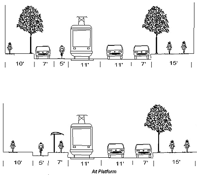
Main St. between Dundurn and Sherman is 50 feet wide. I suggest we have two contra-flow rail lanes on the north curb.
Each lane would be ten feet wide. Two eastbound vehicle lanes would also be ten feet wide.
On the south curb, a seven foot wide parking area could be housed. This could be turned into a short right hand turn lane at major streets.
At transit stations the westbound train which travels along the north curb would veer seven or eight feet to the north and an eight foot (roughly) median station would house the loading and unloading of passengers from both trains.
See the attached diagram from Portland for a basic concept of a median station.

Moodie Avenue Modified Right Running Bike and Streetcar (Image Credit: Portland Transport)
Again, Main Street is 50 feet and this set-up fits rather easily. The only area where it gets a little tight is at stations where the entire width, including street parking on the south side and the median station, would add up to around 55 feet. Perhaps parking could be removed at these points, especially since stations would only be at major streets.
From Sherman to the Delta, the same set up would be used. Main is roughly 42 feet wide here so some slight shaving of the north sidewalk would be necesssary at stations and no parking on the south side at stations. This would only affect Sherman and Gage avenue as the only stops in this leg.
Delta to Kenilworth goes up to 45 feet and is two-way.
Three options can be used here:
Curb transit lanes with raised sidewalk stations and 'bump-outs' for regular HSR routes such as the 1-King to pull over for its stops. One traffic lane each way at around nine feet each with an eight to nine foot wide turning lane down the middle.
Centre of the road transit lanes with median stations (left turn lanes can be built on the opposite side of an intersection with a station). This leaves one lane of traffic each way with left turns only allowed at stoplights and on-street all day parking on one side of the street. However, this setup makes things more difficult for regular HSR service such as the 1-King.
Same as option 1, but allow seven foot parking bays on one side of the street. People would be parking on the opposite side of the tracks, but this is fairly common in other cities (Portland to name one).
The final stretch to Eastgate Square goes almost to 60 feet wide. Right now there is no street parking along here.
At 60 feet, there could be ten foot wide transit lanes on each curb with two full lanes of traffic (ten feet wide) in each direction. No turning lanes, but left turn signals at major lights. This is a total of 60 feet.My suggestion for local buses 1-King and 5-Delaware is as follows:
1-King: Use King Street from Mac to Delta (one eastbound bus lane, two westbound car lanes, street parking on the north curb this can be accommodated immediately with no street reconstruction). Eastbound buses have their own lane, while westbound shares traffic.
5-Delaware: Get rid of the 5E. All Delaware buses would use a two-way Hunter, and then regular routing along Stinson, Delaware, Maplewood, etc.
My final suggestion based on stop frequency in other cities and in keeping with the idea of this being a hybrid between LRT and streetcar service would be to have stations (roughly) at the following locations:
I know this is more stops than the current B-Line, but with exclusive lanes, signal priority and quick boarding/exit it will be a huge passenger benefit to have stops in this type of configuration.
I currently live in Ward 1 and work at Main and Gage. B-line is useless to me since there are no stops between Sherman and Delta. Perhaps in the future we could see an express service of some sort that goes from downtown to Stoney Creek with one or two stops.
However, if we're going to invest in a proper LRT or BRT (by the way, all of the above ideas and configurations work with BRT - there just isn't the same return on investment in terms of private development and urban revitalization like we'd see with rail) the service needs to be convenient as well as modern and quick.
Stations spaced too far apart will hinder ridership growth in huge segments of the central city.
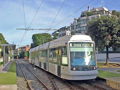
By the way, these are the types of trains I'm talking about:

The 06 T low-floor tramcar in Cagliari, Italy. (Image Credit: Railway-Technology.com)
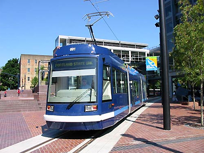
Portland uses the three-car variety because it's a local streetcar route:

The 10 T low-floor tramcar in Portland, USA. (Image Credit: Railway-Technology.com)
My research has found that these trains can be built with the 'shallow slab' method, which allows track to be laid without moving much underground services. Electrical systems are placed underneath the raised platforms.
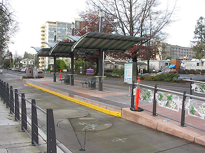
Note how simple stations can be:

Hilyard Station, Eugene Oregon (Image Credit: Flickr)
Portland's streetcar uses shelters similar to our silver HSR shelters.
I've written various pieces on RTH about the return on investment for rail vs BRT. I used to be somewhat skeptical, but the trend is repeated in city after city that goes for streetcar/rail instead of bus.
Long term maintenance and replacement costs are way higher for bus systems as the buses generally last 12 years. Trains can last 25.
Portland and other cities have seen billions of dollars invested within a five minute walk of their streetcar systems. Hamilton could sure use that, and who knows, maybe we'll end up developing future lines to the water or along the Upper James BRT corridor (which by the way, can easily be median the entire length).
By brodiec (registered) | Posted February 27, 2007 at 02:59:47
If you haven't already you should look into the Rapid Transit system the city was basically going to be given in the late 70s. True, it was an elevated train system. Actually it's the exact same system Metro Canada built in Vancouver, better known as the Sky Train. It was voted down by Upper James St. residents because they thought it would ruin their beautiful neighborhood. Which I believe now exists somewhere between the Wal*Mart and that hideous No Frills with the concrete retaining wall that was falling apart on to the sidewalk for about 5 years.
I think the LRT idea is inevitable if this city ever starts to get it's urban poop together. But a focus on fixing the traffic grid into something that respects the rights of pedestrians and neighbourhoods downtown first is probably the first step. Then throw down the rails.
By Nord Blanc (anonymous) | Posted July 15, 2011 at 09:44:37 in reply to Comment 5655
The Durand Neighbourhood Association actually claims responsibility:
--------------------------------------------------------------------------------
Home | About the DNA | Books | History | Join Us | Newsletters | Projects | Community Links | Contact Us
--------------------------------------------------------------------------------
HISTORY
A DURAND CHRONICLE: 1972 - 2004
The Durand Neighbourhood Association came into existence in 1972 when a group of concerned citizens organized themselves to try to stem and bring under control a seemingly unplanned surge of demolition of housing accompanied by massive high-rise development. Their initiative in defence of the integrity of their neighbourhood led to the establishment of Hamilton's first official neighbourhood plan and other measures to bring order to rapid change in the Neighbourhood.
1972 Durand residents organize to protect the neighbourhood from uncontrolled development and demolitions; the Durand Neighbourhood Citizens' Association holds its first general meeting.
1973 A 2,000-signature petition requests City Council to halt demolition and construction until the Durand neighbourhood is planned; the Durand Neighbourhood Association Inc. is formally established as a provincially-authorized not-for-profit association with a constitution and bylaws; a citizens' committee completes the Durand Neighbourhood Plan and Program; Hamilton City Council imposes a four-storey height limit.
1974 The Association joins the City in an intricate legal battle to acquire property for creation of the Durand Park.
1975 The Durand Neighbourhood Plan wins approval with implementation of neighbourhood rezonings; the Durand Park opens followed by a bazaar, the first of many events organized by the Association.
1976 The Association co-operates with the owners in the commercial redevelopment at the corner of Herkimer and Caroline; Sandyford Place is designated as a National Historic site; a children's playground is erected in Durand Park.
1977 The Association proposes an architectural competition for housing on the old Ryerson Public School site; neighbourhood residents organize to save Central Public School from closure in the face of declining enrolment.
1978 Central Public School is recognized as a provincial historic site; the old Ryerson Public School is demolished.
1979 The Association is instrumental in winning City and Ontario Municipal Board support preventing creation of a strip mall at Bay and Robinson; the leasing of the top floor of Central Public School to an insurance company provides an innovative solution to prevent the school's closure; the Association is involved in preparation of a new Plan covering the entire Central Area, including Durand; Site Plan controls are reintroduced.
1980 The City approves the sale of Sandyford Place; the Association joins a three-year, ultimately unsuccessful, battle to save a Victorian mansion at 206 James Street South.
"1981 - A proposed provincially-endorsed elevated rapid transit rail link between downtown and the Mountain running above James South is derailed after fierce opposition by citizens in which the Association plays a key role"
http://www.durandna.com/history.htm
By steeltown (registered) | Posted February 27, 2007 at 09:16:27
If the GO ALRT was a reality Hamilton would of had an elevated guideway along York Blvd with a stop somewhere near Farmers' Market.
We had so many chances
By peter (anonymous) | Posted February 27, 2007 at 10:48:59
you're preachin' to the choir, man. how much $$$ to implement the plan you've described?
By Frank (registered) | Posted February 27, 2007 at 22:22:58
Hey Jay, I should shoot u some of the cross sections I have. Don't know how these compare to Canadian standards but I would assume that they're a little different from Portlands. I'll bring 'em Wednesday. Like the idea... How about getting some better transit out my way (Stoney Creek).
By fastcarsfreedom (anonymous) | Posted February 28, 2007 at 15:50:37
GO-ALRT died for a number of reasons--the main reason being that the funding and impetus at the provincial level both dried up. There was some consternation locally--rightly so, about tunneling under Hamilton Cemetery and building an elevated track down York Blvd. The alternative routing would've gone into the James North CNR station.
The other system was ex-nayed a little more before my time--but I remember the proposals and even the televised debate on CHCH, complete with renderings--I remember elevated trackage shown at King and Hughson. Anyway, the exact system was built in two places--Vancouver and Detroit. In my estimation the system would've been a money loser for years--although with the growth happening now, it may finally have come into it's own. The system itself has a reputation as being flawed--poor dispatch reliability, frequent breakdowns in snow and cold and expensive upkeep.
By Sharchy (anonymous) | Posted March 04, 2007 at 10:42:56
LRT should be Hamilton's top priority for transit expansion. This is the time to act with a plan. The McMaster to Eastgate corridor along Main has the perfect density and socio-economic conditions for it. LRT will spur far more development along the corridor than BRT and has a lower operating cost.
By joejoe (anonymous) | Posted March 04, 2007 at 12:07:07
The feds have just approved funding for Toronto's York subway extension... It's election year for both upper levels of government... It's time for Hamilton to ask for transit funding - now.
By jerry123 (anonymous) | Posted March 06, 2007 at 09:34:04
Hey Jason, do you know if Hamilton is getting any of the funding for a BRT since Mississauga is getting their busway, Brampton is implementing the same thing... ?
By Jordan Kerim (anonymous) | Posted March 08, 2007 at 08:35:41
Hi there. I just want to say how excited I am to see people other than me talk about bringing rapid transit to Hamilton. While I currently live in Toronto, I did live in Hamilton as a child between 1989 and 1993. Having done major research on GO ALRT and having seen the documents pertaining to the Hamilton Wentworth Rapid Transit Project of 1981 I can say wholeheartedly that Hamilton should have rapid transit infrastructure in place (I've even had dreams of Hamilton getting its streetcars back). If you guys haven't seen the article on GO ALRT that I contributed to at Transit Toronto then I encourage you folks to see it. I have always thought that there should be an LRT along Main St from McMaster to Eastgate Mall along with an LRT linking upper Hamilton with downtown via the median of the Clairemont Access Road and Upper James. I also think that GO ALRT should be revived given that the proposed system would have allowed for an exclusive ROW and would have allowed for trains running as often as every two mintues! And if you folks wish to find more info on GO ALRT I encourage that you contact the GO Transit Librarian at GO Transit's head office in Toronto.
By mark (registered) | Posted March 08, 2007 at 12:26:56
Unfortunately, Hamilton was overlooked in the transit announcement. I thought perhaps Harper wsa saving the Hamilton portion of his announcement for when he was in town to watch the brier, but that was just a fluff photo op with no announcements for Hamilton.
Sadly Hamilton has no influence at Harper's cabinet table. You know, many were quick to berate and deride the love-to-be-hated Shiela Copps, but she always made sure that any time money was heading from Ottawa to Ontario a chunk would end up in Hamilton. We sure wouldn't have been ignored if she was still around and the LIbs were in power, or as an Opposition member, she'd make sure to squak loudly until we were noticed...
Where are our local reps and why aren't they complaining loudly about this snub?
Hey Mark,
Why aren't Hamilton's political reps complaining loudly about the lack of transit funding? Great question. But only they know the answer - so...call them and ask them!
By fastcarsfreedom (anonymous) | Posted March 08, 2007 at 15:52:20
Copps held a fistful of high-profile cabinet positions during the Chretien regime--refresh my memory--what exactly did her influence bring to the city in those 13 years? I know she takes credit for the Haida...but I can't think of what else...seriously, she did jack for the city.
By steeltown (registered) | Posted March 09, 2007 at 09:46:01
Copps --> Haida, Canada Marine Discovery Centre, new federal building, Canadian warplane heritage museum, 3 back to back Juno awards, etc.
By peter (anonymous) | Posted March 09, 2007 at 10:31:26
it's not easy getting the big boys in ottawa to pay attention to stinky, little hamilton. she did a great job of bringing us some recognition. everyone knew who sheila was and where she was from. we should be so lucky now.
By alexander (registered) | Posted March 10, 2007 at 00:50:09
After living in Hamilton for forty years moving to Vancouver fifteen years ago and returning to visit on occasion I am distressed to see the deterioration of what used to be a vibrant Hamilton area, Barton Street and its here that a modern upscale transit system shold be considered. Vancouver's Sky Train is part subway and part high level rail and the configuration of Hamilton would require major and revolutionary development at great cost. One can travel from the North Shore by Sea Bus (ferry across Burrard Inlet) to join up with the Sky Train to Downtown and join up with Translink Busses to all parts of Greater Vancouver on the same fare + transfer.A Sea Bus could work between James Street and Burlington. Just a thought.
By Moose (anonymous) | Posted September 17, 2007 at 13:13:07
I think bringing LRT to Hamilton would bring meaning back to the name "Hamilton Street Railway." With the buses only right now in the city, the name is pretty pointless.
By Johnathan Harker (anonymous) | Posted December 09, 2007 at 15:45:51
There is always an obsession with money when it comes to big projects in the GTA. The taxpayers federation, conservative politicians (who would rather us pave over everything), and people with no experience in transport matters are always whining about cost when we are barely playing catch-up with the projects we are paying for now. We could have the transit system we want if we could let cooler heads prevail and stop whining about the what ifs. Some of the greatest engineering projects came from supposed bad ideas.
running above James South
Above James South? An El-train, in other words? Dear heavens. Thank god that particular bit of progressive planning died.
Comment edited by moylek on 2011-07-15 09:58:00
You must be logged in to comment.
There are no upcoming events right now.
Why not post one?