Hamilton has the unique opportunity of implementing a fully-funded LRT before the city is mired in gridlock – an opportunity many cities could only dream of.
By Chris Higgins
Published October 13, 2016
There are several things that a city like Hamilton can do to ensure it achieves the greatest possible return on investment for new rapid transit infrastructure.
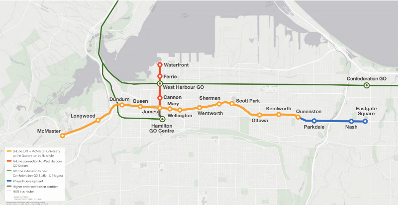
Hamiton LRT route map
Back in 2011, we at McMaster Institute of Transportation and Logistics (MITL) outlined some general lessons learned from experiences with LRT in 30 other cities across North America. Some later research also noted that there are important prerequisites for promoting land use development or change around rapid transit stations.
At the same time, the city's first attempt at planning for LRT was in full swing, and I was critical of the ability of this plan to achieve its goals. Crucially, LRT 1.0 called for running LRT on the side of the street (to maintain high-speed one-way car traffic with the very high potential for collisions as vehicles could cross the tracks at many locations) and a lack of zoning changes along the corridor to promote transit-oriented development (TOD).
However, Hamilton's current rapid transit plans have significantly improved. Compared to version 1.0, the current 2.0 plans for LRT unveiled this past month adopt a 'transit-first' mentality.
The key improvements to me include running transit in a centre median with associated two-way street conversions and, critically, the significant changes to zoning along the corridor that have recently been unveiled.
The city is also experiencing a period of impressive growth, investment, and reinvestment, and the LRT project can complement that growth and help funnel it to the transit corridor.
That said, there is still more to do. The city's LRT plans are only one small part of a larger effort that must be undertaken to support rapid transit. The city's rapid ready report from 2013 was a major step in the right direction, as it states that three 'Rapid Ready Essentials' are necessary to support LRT:
1) Improving Transit: "Structuring the transit network around rapid transit corridors, increasing transit service, and improving the customer experience are essential to build ridership in anticipation of rapid transit and to position transit as a competitive mobility choice."
2) Supportive Community Planning: Promoting transit-supportive land use through changes to the city's zoning by-laws. This includes promoting higher-density, mixed-use, amenity-rich, and pedestrian-friendly development in identified transit nodes and corridors
3) Multi-Modal Integration: "Rapid transit will serve as the main transit spines in the city; however, it is just one aspect of expanded mobility choice. Integrating more travel options will maximize the impact of rapid transit and make it easier to get around the city." This means increasing mobility options and promoting a shift of travel from car to transit and other modes. This includes improving the pedestrian environment, promoting cycling, and increasing transit options.
As noted above, major progress is being made on community planning to ensure that this city grows in a way to support rapid transit in line with the requirements of the Province's Growth Plan for the Greater Golden Horseshoe. Achieving the goals set out for improving transit and multi-modal integration will take more work.
As for the latter, I look forward to the city's upcoming Transportation Master Plan to outline how we will achieve greater multi-modality.
Regarding the former, implementing the City's Ten-Year Transit Strategy must take priority. However, this does not mean we're not ready for LRT, and thus we shouldn't pursue it.
Ridership along the B-Line corridor is already very high. On top of that, the Province of Ontario funded the A- and B-Line LRT project in 2015, and its scheduled opening day is sometime in 2024. This is nearly ten years, which happens to line up nicely with our ten-year transit strategy for city-wide transit improvements.
In that sense, it is a shame that more than a year has been wasted already. The way I see it, this city has received a billion-dollar carrot, now it us up to us to use this incentive as a catalyst to close the gap.
The cost of the strategy is a fraction of that for rapid transit. Whether funding it means changes to area-rating for transit or dedicating more gas tax dollars to transit is another issue, but it seems like a discussion that will have to be had sooner rather than later.
One of the main contribution of my Ph.D. thesis is that Land Value Uplift (LVU) is difficult to predict as there are so many moving parts. However, the theory of how rapid transit increases land values is clear. Like subways or bus-rapid transit, LRT can generate LVU for properties around stations in two ways:
Accessibility: The first is by offering increases in relative accessibility. This means providing a modal option that offers competitive travel in terms of cost and travel time (plus other factors like comfort and reliability) relative to other modes (primarily the private automobile).
For example, a dedicated right-of-way with traffic signal priority can help ensure LRT is fast and reliable, while factors like traffic congestion and the cost and availability of parking can shift trips to transit.
This relative accessibility offers a 'locational advantage' for properties around transit and is a natural incentive for higher-density development.
Transit-oriented Development: The second is through TOD. This refers to a built form that is higher-density, features mixed land uses, is amenity-rich in terms of goods and services, and is pedestrian-friendly through the use of Complete Streets features.
Studies have shown that this type of development is particularly valued by certain segments of the population, namely young professionals and empty-nesters looking to downsize and reduce their vehicle dependency into retirement. TOD is promoted through zoning.
From this, a light rail project like Hamilton's that is designed to offer high levels of transit access and promotes TOD through changes to land use zoning in the LRT corridor has laid the framework to achieve LVU.
As in other cities, I would expect this process of value uplift may have already begun as people speculate about the LRT and it should only increase as the system matures and the city grow around transit.
There are other factors to consider as well. Traffic congestion and reduced parking availability stand to increase the accessibility and LVU benefits of rapid transit.
In terms of TOD conditions, some of my previous research has shown that the corridor's existing built environment is already transit-supportive with an average density of 84 people and jobs per hectare. This is among the highest-density transit corridors in the region - higher than many other LRT and even subway projects in the region.
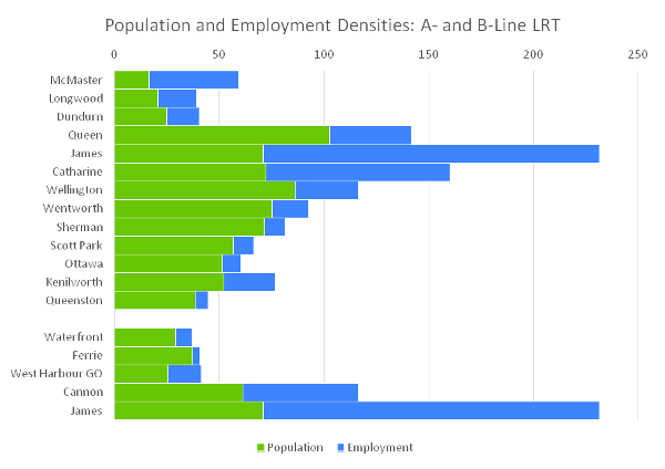
Chart: Population and employment densities along the B- and A-Line LRT
Mass transit requires mass to be successful. Above you can see the distribution of people and jobs per hectare in each station area, and the A- and B-Lines have an average density of 84. With a total of 96,000 people and 51,000 jobs within walking distance of a station (using census data from 2011), the A- and B-Line plan serves the most transit-supportive corridor in Hamilton.1
To me this means the corridor has good TOD 'bones', and the LRT project can activate this built form to produce LVU over time.
I should clarify though that when the Mayor and others talk about 'economic uplift' from LRT, they are speaking of two things. The first is LVU - increases in the value of land and higher-intensity development around rapid transit stations that decreases the tax burden on other areas of the city.
The second uplift is from is an overall direct and indirect boost to the economy. This comes from the direct injection of $1 billion to support construction and other jobs in the city over the short term.
Economic uplift also occurs indirectly through economic development in the years and decades ahead in a city that lays the framework to foster and attract new businesses and jobs in the post-industrial economy.
Rapid transit in and of itself cannot not cause this growth to occur, but it can certainly play a very large part in an overall package of elements that makes cities like Hamilton attractive to young professionals, entrepreneurs, or businesses that are increasingly looking to high-density and amenity-rich downtown areas to work and live.
There are three dimensions to the issue of traffic congestion in my mind.
The first is that the reason traffic moves fairly well throughout the day in Hamilton, at present, is its network of large one-way streets and timed signals. From a traffic engineering or mathematical perspective, this design maximizes the throughput of these streets, allowing large numbers of vehicles to traverse the city relatively free of delay.
However, research led by a colleague of mine concluded that this emphasis on throughput also comes at a cost, namely a compromised pedestrian environment and suppressed economic vitality. This is not to say cars should be banished from the lower city, only that a balance needs to be struck between competing demands on our public space.
Second, it's not a matter of if the corridor will be congested, but when. We are already seeing some congestion during peak periods for east-west travel in the lower city, even with its current road design.
This congestion will only get worse as this city adds more than 200,000 people and 100,000 jobs over the next 25 years, well on its way to a population of 1 million. Put another way, this is like adding Kitchener on top of Hamilton.
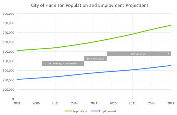
Chart: Hamilton population and employment projections
The challenge then becomes accommodating this new growth on top of the delays we are already seeing. Traditionally, this growth would have been in auto-dependent suburbs near the Greenbelt whose residents then fill up the Linc, Red Hill, and Highway 403. In response, we could expand our highways even further, but it has been proven time and time again that adding capacity doesn't result in less congestion - just more drivers.
However, under the Province's Growth Plan for the Greater Golden Horseshoe, much of that growth will be within the existing built-up area, funneled to key nodes and corridors.
How to manage all this new corridor traffic? Downtown roads could be widened even further, but if you think the slivers of land slated for expropriation to accommodate LRT are bad, how much more land would be required to widen Main or King Streets, particularly at the international village bottleneck?
Traffic models show that traffic congestion in this city will increase - with or without LRT. The trick then is how to best manage it. Given that traffic congestion can't be moderated by adding road capacity for more vehicles, LRT is a smart tool that allows us to increase the capacity of the corridor to move more people.
The third issue is parking. This city has dedicated a quarter of its downtown land to the storage of private automobiles. While often overlooked, this is a key element that makes travel by car cheap and easy in this city. However, parking is not the most productive use of land, especially land in the downtown core.
New zoning rules will make this land easier and more profitable to develop, improving the economic vibrancy of downtown and increasing commercial and residential tax revenue for the city, but decreasing available parking spots and increasing the cost of spots that remain as demand increases.
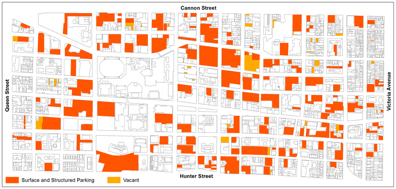
Map: parking in the downtown core
Taken together, finding a better balance between automobile traffic and other uses can help the vitality of our neighbourhoods and downtown. Vibrant streets like Yonge or Queen and King in Toronto or even our own James street do not feature skinny sidewalks inches from multiple lanes of high-speed one-way traffic.
One cannot lament the challenges facing the downtown core and east- and west-end lower city while simultaneously seeking to maintain this status quo.
On top of that, more congestion and less parking thanks to population and employment growth will result in increased transit use among drivers over the coming years. Just think of Toronto - if you want to go see a Blue Jays game, you accept that the 403 will be congested and stressful and that parking downtown will be expensive, so many will choose to take the GO train.
Not everyone has to take transit, but if the GO train didn't exist, all of that traffic would be right beside you on the 403 and fighting you for a spot in the city.
Hamilton has the unique opportunity of implementing a fully-funded LRT before the city is mired in gridlock - an opportunity many cities could only dream of.
LRT does not require anyone to give up their car, it simply provides another option for travel in Hamilton - one that many individuals will benefit from directly and indirectly. A family may find, for example, that improved transit allows them to get by just fine with one car instead of two or three, which adds up to a significant direct cost savings.
Indirectly, this city is and will continue to grow and change. Above I noted that we will see new population and employment growth, added density, increased traffic congestion, and removed parking, all of which will influence transit use. One thing I have not yet mentioned is changing mobility throughout a person's life cycle.
People cannot rely on their cars to get them around forever, and transit access is a key component in the quality of life of many seniors. Taken together, you, your family, or your neighbour's family may one day find that rapid transit fits your needs and will be glad you have the option.
I am encouraged to see support for rapid transit in Hamilton, whether it is LRT or bus rapid transit (BRT). However, assertions that the two options are radically different from one another are not accurate.
The B-Line as we know it today is not BRT, it is an express bus, and it is 'express' because it skips some stops. In contrast, BRT - like LRT - is designed to run in a separate right-of-way with full stations at similar spacing and signal priority at intersections. These features are what enable the 'Rapid' in Bus Rapid Transit, just like LRT.
And like LRT, investments in BRT work best when the same supportive plans and policies are in place. So aside from trains on tracks or buses on concrete or pavement the two modal options are fairly similar in terms of operation and potential construction disruption.2
No matter which is chosen, there is still $80 million worth of underground infrastructure that will need to be replaced over the coming years, and the funded LRT project covers that cost.
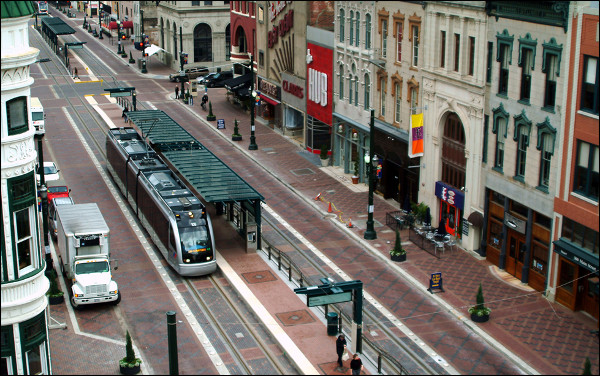
LRT in Houston, Texas
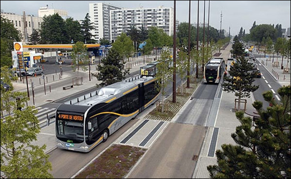
BRT in Nantes, France
However, there are some other important differences between the two modes that should be considered. Below is a nice summary table from Vukan Vuchic, who has been doing this a lot longer than I have:
| Mode Characteristic | Bus Transit System (BTS) | Bus Rapid Transit (BRT) | Light Rail Transit (LRT) | Superior Mode |
|---|---|---|---|---|
| Investment Cost | Medium | High | Very High | BTS |
| Implementation Complexity and Time | short | Medium | Long | BTS |
| Operating Cost | Lower for Low Passenger Volumes | Lower for Low Passenger Volumes | Lower for High Passenger Volumes | Depends |
| Operating Speed | Medium | High | High | Depends |
| Ability to Accommodate Service Options | Lower for Low Passenger Volumes | Some with Four-Lane Stops | Low Except with Four-Track Stops | BRT |
| Capacity | Lower for Low Passenger Volumes | Medium | High | LRT |
| Type of Energy and Traction | Internal Combustion Engine | Internal Combustion Engine | Electric | LRT |
| Vehicle Performance | Good | Good | Excellent | LRT |
| Air Pollution and Noise | Poor | Poor | No Local Pollution, Low Noise | LRT |
| System Image and Passenger Attraction | Fair | Good | Excellent | LRT |
| Potential to Influence Land Development | Limited | Fair | Very Good | LRT |
| Contribution to Livable urban Environment | Some | Limited | Excellent | LRT |
You'll notice that LRT comes out ahead in many ways. While it has a larger up-front cost and is more complex to implement, it offers superior performance to BRT across a number of important indicators.
The only real toss-ups are on capital and operating costs and service options.3 The major reason cities typically pursue BRT is savings on short-term capital costs at the expense of long-term operating costs.
In Hamilton's case, the larger capital costs of LRT are being funded 100% from the Province's Move Ontario Forward plan.
On the operations front, it costs the same amount of driver salary to operate an empty vehicle - bus or train. However, the higher capacity of a train means this cost can be spread over more riders. One topic not mentioned above is maintenance costs, and again Light Rail Vehicles have an advantage over buses in that less wear and tear from tracked operation means they last significantly longer.
Taken together, LRT as a technology offers very high quality ride performance, a superior image that has a track record of attracting more by-choice riders, better long-term cost performance, and characteristics that contribute to a more transit-oriented and livable urban corridor.4
The city, Metrolinx, and Government of Ontario know this - don't forget that we compared LRT and BRT for Hamilton in 2010 and found that despite the higher capital cost, LRT was the best investment.
While there has been some passionate debate in this city over the past few months, remember that rapid transit is just a tool for a job, and it is in my opinion an important one for Hamilton's future.
There are outstanding questions on the nitty-gritty details, but at this early stage of the game there should be, and like me you should have no reason not to believe that answers are coming as the project progresses.
Nevertheless, the conditions are ripe: the city is growing and revitalizing, new zoning rules have been proposed to support rapid transit, and increasing congestion means we will need rapid transit to move more people in the near future.
We should also rationalize the debate to start with some common realities about how and where this city is growing, and the economics of higher-density intensification versus low-density sprawl.
LRT is a key part of a smart long-term strategy for managing growth in this city - infrastructure to grow around over the coming decades - not to mention elements like economic uplift that I touched on here, plus other things like reductions in air pollution and healthier neighbourhoods that I have not covered.
On top of that, discussions of BRT versus LRT need to take the specifics of each mode into account. They are simply not that different. With that in mind, supporting more express bus service should not be equated with supporting rapid transit. Likewise, other options will continue to be limited by road capacity. Whether or not a car is electric, driven by someone else, or driver-less - there is only so much space.
People in this community should be suspicious of the intentions of anyone ignoring these facts as it emphasizes short-term views and politics over responsibly planning for the longer-term future of your city and does a disservice to you as a taxpayer.
There is nothing inherently wrong with being anti-LRT, but the onus is on these groups to provide an alternative. To put it more bluntly, the challenges this city faces over the coming years require more constructive thought and articulation than just "NO".
And beyond taking the above into account, any alternative must also acknowledge the opportunity costs involved in losing all the work, engagement, political capital, and momentum from unanimous and near-unanimous votes required to bring the present plan to fruition over the past ten years.
Finally, I would encourage people to refocus on the bigger picture. In many ways this lively debate has taken our eyes off the ball. The A- and B-Line LRT is a long-term project, the cornerstone of the city's growth plans and the start of the BLAST rapid transit network that will span the city.
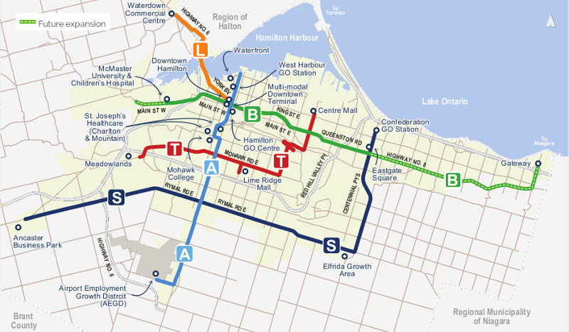
Proposed 'BLAST' Rapid Transit Network
The most important short-term issue is not BRT versus LRT, two-thirds majorities, or referendums - it is council working together to implement the ten-year transit plan to expand transit service throughout Hamilton in the critical window prior to LRT and working on securing local, federal, and provincial funding for the first extensions.
This article is adapted from a response to questions from The Hamiltonian.
1. For comparison, the average density of the B-Line phase 2 to Eastgate square is 46 people and jobs per hectare, and the A-Line from downtown to the airport is 36.
2. Compared to LRT, the right-of-way for BRT is wider than that for LRT as it has to allow for more lateral movement of the bus.
3. Service options basically means the ability to accommodate express services that skip stops and requires 4 lanes or 4 tracks like express trains on the New York City subway - not something Hamilton could fit in the corridor or that it needs.
4. Regarding electric propulsion for BRT, one could employ the electric trolley buses or the hybrid buses we currently use, but the weight, range, cost, and capacity constraints of today's full battery-electric buses make them ill-suited for rapid transit.
By KevinLove (registered) | Posted October 14, 2016 at 08:22:33
Traffic models show that traffic congestion in this city will increase - with or without LRT.
Kevin's comment: Then those traffic models are inadequate. It is possible to permanently eliminate traffic congestion using the Dutch model as a benchmark. There are two basic components to this model. The first is making the downtown car-free. For a good example, see this video on Utrecht.
The second component is to have all other neighbourhoods, outside of the downtown, follow the Neighbourhood Strategy. What this means is that throughout the city, people walking, cycling or using public transit can travel straight from A to B. Anyone who wants to drive a car cannot do this. A car driver would have to drive out from their neighbourhood to Hamilton's surrounding ring road of the 403/Linc/Red Hill/QEW/Burlington Street. Then the car driver would drive around Hamilton until opposite his destination neighbourhood. Then the car driver would drive from the ring road into their destination neighbourhood. For a good example of this, please see this video on Groningen
The net effect of doing this is to ensure that the fastest, easiest and most convenient way of travelling from A to B in Hamilton for most trips will be by walking, cycling or public transit. Relatively few people will be driving cars.
Since walking, cycling and public transit are far, far more efficient uses of valuable road space, the Dutch strategy will effectively eliminate traffic congestion for the foreseeable future.
Any system of traffic modelling that does not include the Dutch model must be considered inadequate and incomplete.
Comment edited by KevinLove on 2016-10-14 08:23:41
By Haveacow (registered) | Posted October 14, 2016 at 10:00:04
One of the things that is generally glossed over by BRT supporters is evident in the BRT picture from Nantes France, chosen by the author of the article. Here in Ottawa we learned very quickly if your BRT system becomes anywhere near successful and or has some of its busiest stations located on a station site that has any physical limitations of any kind, then you have unintentionally limited your passenger carrying capacity. In that picture from France those buses can't move around slower buses or avoid buses that have stopped at stations. Thus, the built form of the busway can and often, dictate the type of busway operation chosen. This type of busway limits the bus through put and needs to maximize its very limited system capacity, as well as also limiting the travel options for passengers. Meaning there are very few choices of route and thus more transfers are necessary if the passengers need to go somewhere else beyond the limited route choices operating on the busway.
Regardless of the choice of Busway operation, as soon as your capacity runs out you have to spend a lot of money with BRT to upgrade the right of way, much more than you would, than a carefully thought out LRT system. BRT starts out as a cheap an easy less expensive construction option compared to that of LRT, quickly becomes a financial and or infrastructure based trap that, forces high operating costs and even higher BRT right of way upgrade costs. Again if the stations are located in physically limiting environments any capacity upgrade to a BRT system becomes, a massively complex expansion that not only requires greater amounts of money than LRT expansion but requiring considerably more space, especially right of way width.
BRT supporters who think painted lanes are a way to high capacity transit are also disappointed because once passengers levels exceed certain levels. Passenger levels by the way, not much higher than your current B-Line right of way passenger levels. Buses either have to either leave the bus lane and travel great distances in the general traffic lanes or sit backed up behind other buses. Thus, if a BRT system wants more than just the basic capacity offered by painted bus lanes, a physically segregated right of way similar to what you see in Nantes France, or with the VIVA BRT Rapidways in York Region North of Toronto become necessary. Higher capacity BRT systems require even more space and expensive infrastructure. Mississauga or Ottawa Transitways have 2 lane physically segregated rights of way, sometimes even grade separated, with 4 lane capacity at stations. Each lane by the way is 4 metres wide, the widest traffic lane you will ever see, this prevents mirror strike in non guided buses. Plus at least 2.5 metre shoulders for snow removal and water drainage. The stop over lane at the station is usually 3.5 to 4 metres wide as well, plus the full width station passing lane.
As Ottawa's Confederation LRT Line stations in the eastern segment approach completion and LRV testing begins soon (LRV testing has already started in the Yard), it is becoming easy to see that the new LRT right of way is considerably more marrow than the existing Transitway, especially at the stations. Many station design pictures show wide walking paths and possible gardens parallel to the LRT right of way, which was always commented on by a very skeptical public in Ottawa as "ya right, they will not have the space to do that at stations". Turns out that yes, LRT stations really don't require as much physical width as our old Transitway Stations did, so there is space for walking paths and gardens, assuming they don't get cut by the tense budget process the line is going through. The project is still on budget but they have blown through most of the contingency funds to clean up Rideau Street and deal with the fact that, many of the existing concrete retaining walls and bridges they were planning to reuse from the Transitways were in a lot worse shape than first thought.
By mdrejhon (registered) - website | Posted October 14, 2016 at 11:12:10 in reply to Comment 120275
I was born in Ottawa and am throughly familiar with the Transitway, ever since first riding our wonderful Ottawa BRT in 1983, even before the Billings Bridge Transitway extension.
For a long time we prided on being the world's biggest BRT system, and one of the best bus transit networks in North America! BRT can be wonderful systems, you definitely preferred catching a bus on the BRT as you got to nearly freeway speeds with the intersection-less BRT right of way. But there are definitely cons too -- like what you described -- and what Chris described.
There are other BRT systems that stay 2-lanes rather than 4-lanes, but these lanes are still extremely wide (about 4 meters). And the platforms are at least as wide, so even in the best case scenario, I've never ever seen stations on true-BRT systems narrower than LRT stations.
There are also BRT systems that go through level intersections too, helped along by traffic priority signalling -- just like Hamilton LRT plans to use. In the best case, if Hamilton LRT was the Hamilton BRT, it would still require just as much space (and, alas, expropriation) if the whole B-Line route was dedicated BRT lanes and bare-minimum 2-lane BRT stations.
Visit Ottawa and look at their 4-lane BRT stations and you really see how big the stations are -- compared to the token bus shelters (and in many cases, no bus shelter) on the B-Line route.
By Tybalt (registered) | Posted October 14, 2016 at 11:56:31 in reply to Comment 120277
I agree Mark. The Ottawa Transitway stations are huge; there are street-level "stations" (stations on the map) that are just bus stops and shelters along Transitway or 90-series routes, but there is no true BRT in those areas; they are in mixed roadway traffic. Where there is a true station, they are of a significant size (thinking especially of the Lees or Cyrville stations I ride frequently from my mother's building to downtown).
By Haveacow (registered) | Posted October 15, 2016 at 08:21:30
Tybalt, you brought up a point that Chris hinted at in his article and it is indeed a very important one. BRT or Bus Rapid Transit has an image issue. Planners have often use the terms Real BRT, or BRT vs. "BRT Lite". Many politicians have used the term BRT to describe a bus transit operation that includes everything from an improved bus service that only stops at every second stop or a simple express bus line that has really nice and high tech or "tarted up" bus stops. They (the politicians) almost never include physically segregated rights of way over much or all of the proposed route, which has always been in my opinion the real indication of true BRT.
I accidentally exploded on a politician during an open house with a project I was working on over this issue. Now, he wasn't personally responsible for this entire phenomena and I did apologize to him later but I was very angry because it was usually falls on planners like me who have to explain some very basic points about BRT to people at public meetings like this. The disappointment and shock on their faces when it is explained to them that, the bus route they thought was BRT and which really only had a marginal improvement on ridership compared to what existed before it, which was also highly touted by this particular city as BRT, really wasn't. The idea that, I was now showing people at that meeting what was really true BRT and it turned out to be a lot more expensive and intrusive than what they had first thought and believed BRT was. The public then screams at you because now they fear that I maybe lying to them and misleading them to what BRT actually is or isn't. The public just doesn't know for the most part and they are angry about being lied to by politicians. The meeting was definite learning experience for me.
This image issue with BRT also includes the political phenomena of "BRT Creep" which, usually due to budgetary and political reasons, is when a BRT project suffers many small performance and infrastructure cuts to it over its development and the end result is something that doesn't even come close to being true BRT. However, the same project is touted as a fantastic example of BRT to the public by politicians. When this compromised system is then opened to the public complaints soon follow expressing there disappointment with a transit system which is very obviously not in the category of rapid transit in anyway.
I have sometimes been accused of being anti-bus and pro-rail. Which I am neither. My problem is that the basic premise that politicians and people who either don't truly understand or don't care about transit usually believe about BRT is just so fundamentally flawed, "BRT is just like any rail based rapid transit system, only cheaper!" A rail line with buses, cheaper, simpler to operate and implement, compared to rail based transit systems. The core of the equation is that cheaper is better, in all respects. This is just plain wrong! The reality is that BRT and LRT for example as transit operating technologies, compliment each other instead of contrast and both have some capabilities in common. However, once you have a BRT or rail based transit technology like LRT in place, both operating technology choices require very different types of experts and experiences to own and operate. The reality is that, they are different systems with different capabilities and different operating issues. Both have to be operated in very distinct and separate ways for either of them to be successful. It took most of our local politicians and rabid BRT supporters here in Ottawa, 3+ decades to figure that point out.
You must be logged in to comment.
There are no upcoming events right now.
Why not post one?