The City of Hamilton is currently reviewing the Cycling Master Plan as part of its Transportation Master Plan review. Here are my two cents.
By Jason Leach
Published July 29, 2015
First off, I want to mention how exciting it's been to see the success of the Cannon Street Cycle Track and Hamilton Bike Share. We should be making a huge deal about how well our bike share has already done compared with other bike-shares, notably Toronto.

Hamilton Bike Share bike: HAMILTON IS BEAUTIFUL!
I believe there is great momentum in the cycling arena and it would be a shame to see no new bike lanes added in 2015. Here are some suggestions for easy, low-hanging fruit that we could grab in 2015:
Install parking-protected bike lanes on Herkimer and Charlton, as requested by the neighbourhoods. Parking-protected bike lanes are among the safest in the world. The evidence is clear on this. Copenhagen, Montreal and every other city on the World's Top 20 cycling cities have grown ridership with these lanes city-wide.
Install a bike lane on Locke from Hunter to King. This has been delayed far too long and could be done overnight. Parking could remain from Hunter to Main and the stretch from Main to King is very easy.
We need much clearer signage city-wide. Here is a simple example that is used all over the world:
")
Bicycle wayfinding sign (Image Credit: City of Gresham, Oregon)
We need to design and label our network as though we are riding a bike for the first time or are tourists.
This also applies to our multi-use paths. Some are more suited to leave as simple black asphalt with basic signage as shown above. Others, such as the new ones on Longwood/Aberdeen and on the side of York Boulevard, need markings on the road and signage on the route making it ultra clear that it is part of the network:
")
Multi-use path pavement markings (Image Credit: American Trails)
We need to do better at linking our bike lanes - especially through intersections, where the bike lanes tend to disappear. One example of a bike lane link that should be improved is the corner of York and Dundurn.
")
Bike lane on York at Dundurn: no obvious way to turn left (RTH file photo)
There is ample space in all directions for the bike lanes to connect on these streets. Simply ending bike lanes before corners is dangerous and creates a huge gap in the network. It is a major barrier to new cyclists.
The evidence from other cities shows huge uptake from riders on these stress-free, low speed limit, speed-humped routes. RTH editor Ryan McGreal and I drafted up a proposed network for Hamilton:

Map of proposed neighbourhood greenways
The City of Portland defines neighbourhood greenways as "streets with low traffic volume and speed where bicycles, pedestrians and neighbors are given priority." over through traffic.
They're designed so it's easy to walk or bike down the street but hard to cut through in a car. Speed humps slow traffic, diverters stop drivers from "rat-running" through the neighbourhood, and safe crossings allow pedestrians and cyclists to get across busy cross streets.
")
Neighbourhood greenway in Portland (Image Credit: City of Portland)
Neighbourhood greenways are great because they not only make the street better for walking and cycling, but also make it safer and more pleasant for people who live on the street.
We literally have a 'ring corridor' around and through the east/west ends of the city. I realize Hydro companies initially say 'no' when approached by cities, but we need to push the way Toronto has to take advantage of these great routes:
")
Cycle track on Hydro corridor in Toronto (Image Credit: BlogTO)
Here is an initial map I did up, but I've since learned of more corridors: through the Cootes-Escarpment Eco Park for example, and across various rural areas.
")
Hydro corridor crossing Lawrence Road in east Hamilton (RTH file photo)
Connecting these pathways to the city network would be a dramatic improvement in our cycling network.
When City streets are being reconstructed, bike lanes should be built at the sidewalk level, not the street level. Otherwise, they should be physically protected with bollards, curbs or parallel parking as a standard practice. We know that protected bike lanes get a lot more people riding bikes in a way that painted lanes just don't.
Here are some great routes for protected cycle tracks:
We should also be providing this on all north-south mountain arterials that don't have a Lincoln Alexander Parkway interchange.
Another opportunity lies in adding off-street multi-use paths on every large institutional/retail property or city park where appropriate. Examples:
I feel these streets are well suited for such facilities. All of these types of bike facilities would launch us into a top cycling city, along with completion of the rural cycling path network.
By mdrejhon (registered) - website | Posted July 29, 2015 at 11:28:47
A glaring omission is protected bike lanes on Gage Ave, going southwards from Cannon.
The proposed bike network pictured was designed well before SoBi's heat map came to being: https://raisethehammer.org/static/images...
Observe the Delaware-Stinson being a very popular bike route, as the method of accessing Gage Park.
Comment edited by mdrejhon on 2015-07-29 11:34:30
By matthewsweet (registered) | Posted July 29, 2015 at 11:33:11
Is it just me or is the formatting of the article all wonky? For example, "bollaRoads" instead of "bollards" where the "rd" is being expanded to "Road". Street, Avenue etc are all showing up that way mid-word.
By mdrejhon (registered) - website | Posted July 29, 2015 at 11:35:27 in reply to Comment 113151
Sounds like an AutoText/AutoCorrect issue. Someone typed on an iPad, possibly.
$article ~= 's/Road/rd/g';
$article ~= 's/Avenue/ave/g';
$article ~= 's/Street/st/g';
...would probably do the trick. Though you may want to make sure it's non-full-word matches (e.g. not a word boundary) since it would affect the phrase "Cannon Street Cycles". A different regex should do the trick :-)
Comment edited by mdrejhon on 2015-07-29 11:39:29
By StephenBarath (registered) | Posted July 29, 2015 at 11:38:38
You included Dundurn between Main and King on the list of protected bike routes, but left off the rest of Dundurn. Dundurn's bike lanes are terrible- completely unprotected, frequently encroached by all kinds of motor vehicles, rarely maintained in winter, fading in places. The entire length of Dundurn should have protected bike lanes (they may not be called for south of Aberdeen).
Your points about the low-hanging fruit are good. Those are all easy.
By mdrejhon (registered) - website | Posted July 29, 2015 at 12:43:22
How can we expedite the low-hanging fruits before the end of summer season?
There are people in our Hall who probably already agree today (even Fred Eisenberger advocated SoBi expansion), and I know my ward's councillor Matthew Green is all for it.
We're not asking for a bike lanes megaproject -- but work on a few blocks here and there to fix bike-lane gaps (only one to three blocks long) and fix dead-end-bike-lane issues that suddenly end in the middle of nowhere, or tells me to turn onto a nearly dead-end street, without knowing where the bike lanes resumes (often just two blocks later). For example, riding eastwards home from Downtown Hamilton GO Station -- how do I ride from Hughson bike lane to the Stinson bike lane?? I got lost once, and had to carry my bike down a staircase when I actually didn't have to.
This would be politically/business less risky than installing bike lanes on Locke (it definitely should happen eventually, but there are even LOWER HANGING fruit that has near-zero political risk -- there's a stupid one-block bike lane gap on Hunter when riding eastwards from Downtown GO)
This is where I was: Hunter St eastwards, forced left on Liberty St. S
This was my next view: Liberty St southwards
Where do I go to keep going eastwards? I keep riding until next sign.
Two blocks southwards, I am being forced to turn left again -- a U-turn! End of Liberty St, with one-way sign forcing me to turn left on Grage St
Comment edited by mdrejhon on 2015-07-29 12:59:18
By mdrejhon (registered) - website | Posted July 30, 2015 at 14:59:22 in reply to Comment 113156
s/Hughson/Hunter/ (duh -- I meant Hunter, not Hughson)
By mdrejhon (registered) - website | Posted July 29, 2015 at 13:07:53 in reply to Comment 113156
(annoying 30 minute edit timer, despite error message of 90 minute edit timer; lost some text and Google Street View links as I was adding extra bullets...we need /either/ an autosave or permit 90 minute edit limit rather than a 30 minute edit limit...now resuming)
...continued...
.5. Peeking left instead, saw corner with stairs. Walked my bike. Stairs from Grange St to Young St
.6. In retrospect, I should have turned left onto Grove St from Liberty. Grove St, parallel street 1 block south of Hunter St but there were no bike markings and I wasn't sure where it led to.
Solution:
A) Extend Hunter St bike lane 1-2 block eastwards to Wellington St S Hunter St, at Wellington
B) Protected bike lane for 1.5 blocks southwards to Stinson Street Unprotected Wellington St, not inviting for bikes
C) Upgrade the sharrows on Stinson Ave at Wellington St until it reconnects to the Stinson painted bike lane two blocks eastwards.
Until then, it's a very, very,. very confusing eastwards bike commute from Hamilton Downtown GO. Once you're on Stinson, there's now many routes (South of King) to safely commute to all residential areas all the way to Gage Park.
By fixing a mere 3.5 blocks of bike path gap, we greatly upgrade the bikeability of the Hunter-Stinson-Delaware bike corridor towards the Gage Park area (Which shows up very hotly on the aggregated SoBi GPS bike route heatmap, too), by fixing the bike lane gap between Hunter and Stinson. Contentious storefront parking is not involved here, and the residential parking is always very light; the homeowners can always park on the opposite side of the street or on a side street, now that bike traffic has increased (thanks to SoBi) that the bike is the more valuable greater good than lightly-used residential streetside parking.
We only need cheap paint for this. This is a much, much, much lower lying apple than installing protected bike lanes (at a high enough quality to meet Locke St standards -- it deserves full Cannon-style treatment at the minimum) when bike traffic has reached high enough levels to bring more Locke business than cars. It's almost there, or finally arrived there already, but let's focus on lower lying apples first, and make sure the Locke BIA is onboard, and businesses work with us.
That takes time, but the broken Hunter-Stinson bike connection is something that can be fixed in one weekend of reparations work. It may require eliminating one streetside parking on Wentworth (for only 1.5 blocks!) but more bikes pass those 10 Wellington streetside parking spots than cars park in those spots, and now it's a greater public good to reallocate that road surface to a protected 2-way bike lane (Cannon-syle) for just a mere 1.5 blocks to safely connect Hunter and Stinson.
Therefore, let's fix easy gaps like these during August 2015 -- 3.5 blocks of missing connection between Hunter bike lanes and Stinson bike lanes!
Comment edited by mdrejhon on 2015-07-29 13:25:27
By Anna27 (anonymous) | Posted July 29, 2015 at 12:51:08
I recently biked up Wilson St. E into Ancaster and was at first really pleased with the very wide bike lanes running up the escarpment there (and blessedly free of much debris/gravel, which is often an issue with bike lanes).
So it was completely disconcerting when the lane just...ended, right in the middle of a block suddenly throwing me into sharing the lane with some heavy traffic. No wonder I was the only person using the bike lane!
By KevinLove (registered) | Posted July 29, 2015 at 19:57:09
An excellent article!
A proper transportation network achieves the goal of making walking, cycling or public transit the fastest, easiest and most convenient way of safely travelling from A to B.
For cycling in particular, there are three keys to success:
Eliminate cut-through "rat-running" car traffic in residential areas.
Install protected cycle lanes on all through streets to produce a dense grid of cycle routes.
Achieve a car-free downtown as a vibrant and prosperous place for people where people really, really want to live because there is such a high quality of life once we've got rid of the cars.
By StephenBarath (registered) | Posted July 30, 2015 at 10:46:58 in reply to Comment 113175
"1.Eliminate cut-through "rat-running" car traffic in residential areas."
This is important for so many reasons. I do not understand why this hasn't been done.
What are the barriers? In newer suburban developments, great lengths are gone to prevent through traffic on residential streets when designing the network (unfortunately, this also means they often have huge barriers to walking, too). Based on that, I assume that people understand that it’s undesirable to have fast-moving car traffic on residential streets, and that it’s an impediment to safety, enjoyment, and choice in how one gets around. So why aren’t we doing it? How can we make it happen?
By mdrejhon (registered) - website | Posted July 30, 2015 at 09:18:50 in reply to Comment 113175
A car-free downtown is utopia fiction at this time for Hamilton.
(as much as I like Copahagen -- and wish we had a 'tourist bike district' in Hamilton that's fully Copahagenized).
Let's start small. We begin with car-free International Village for 4 blocks when LRT arrives. Mini Queens Quay treatment. Four SoBi stations, 2 LRT stations, dedicated bike lanes, nice wider pedestrian walk area, landscaping. Baby step. Circa 2024.
We need to make sure that it's done in a way that businesses actually improve, not get worse -- as we are in a city state where adjustments -- delicately speaking -- are rather delicate (car-owner in me heavily arguing with the bike-owner in me, in a mental fist fight -- ha!)
Comment edited by mdrejhon on 2015-07-30 09:23:18
By LOL_all_over_again (registered) | Posted August 06, 2015 at 04:59:25 in reply to Comment 113183
By KevinLove (registered) | Posted July 30, 2015 at 16:26:28 in reply to Comment 113183
The same thing was said in pretty well every Dutch city before their downtown went car-free.
The sky didn't fall. Indeed, as soon as people successfully got rid of the cars, suddenly the city became a much nicer place for people, particularly children. Here is a video of children fighting against car traffic in the De Pijp residential neighbourhood of Amsterdam in 1972.
We can see all the same problems in the video that plague Hamilton today. But De Pijp got better. The people eliminated the rat-runs, made many streets car-free and the rest with 30 km/hr speed limits enforced by the infrastructure.
Hamilton can do exactly the same things. In De Pijp, they changed. We can too.
Comment edited by KevinLove on 2015-07-30 16:29:57
By LOL_all_over_again (registered) | Posted August 06, 2015 at 05:01:59 in reply to Comment 113201
By mdrejhon (registered) - website | Posted August 11, 2015 at 13:06:46 in reply to Comment 113294
I agree we can never be a Dutch city, but Main/King status quo has definitely got to go.
A very good example is the upcoming (eventually to be highly popular) International Village-and-Gore combined pedestrian district:
This is how the currently-still-mostly-useless Gore Park pedestrian road, that was probably built slightly too early -- finally actually becomes really useful and finally touristy (in 10-15 years), in combination with a pedestrianized International Village (with only LRT/sidewalks/cycle paths/median trees/fancy steeltown ironwork benches/etc), and now that the area would be no longer an expressway island with Main 2-way, with all the new condo residents, it kickstarts a calm crowd with baby strollers and enjoyment, attracting more people (like me) who lives 20-30 minutes walk away closer to Gage Park, who otherwise take Stinson/Cannon bike lanes, but would end up liking to ride a bikepath route that intersects the beautiful International Village-to-Gore Park cycle path (on the pedestrianized road), and businesses in this BIA will boom as a result.
Apparently, segments of this micro-utopia are already in Hamilton's master plan, the Hamilton LRT plan, the funding for higher-order pedestrians. The shuttered storefronts will completely disappear from Gore Park. So, you see, the Gore Park pedestrian road was built approximately 10-to-15-years too early.
This is still far smaller than even Minneapolis and Boston's still-tiny pedestrianized districts, but this is a great area to begin one because of the bullet list of simultaneous converging factors. Considering we're almost certainly going to end up having to do Main 2-way in the LRT era, anyway -- might as well also make it people-friendly and sieze this amazing opportunity of this grand confluence of condo-LRT-IV-Gore-etc revitalization opportunity.
This is a massive improvement for Hamilton Downtown, and a genesis of a massive explosion of employment opportunities in the next 20 years too, when the Downtown finally is over the hill of its depressed Detroit-style look of not too long ago.
The City started the Gore transition (and, YES, it looks like a aborted transition given the shuttered storefronts at Gore), and there is a lot of inertia, but the critical mass of people-friendliness will finally hit this specific area once the LRT/condos/paths/etc are complete. The bullet list above points this out.
Momentum is strong; the brand new war memorial is totally amazing and I appreciated it now covers recent war history including Corporal Nathan Frank Cirillo (RIP -- 2014). Along with this, the SoBi bikeshare rack has also made me visit Gore a bare tad more often, and as long as the city keeps it up, I am pretty confident this area is a big-time pedestrian draw 15 years from now, like specific districts in American cities. My Lower City neighbours who visited Gore Park for the first time 5 years are amazed what an underutilized resource we have in the center of our city! The same stick of dynamite that lit James St N (it took time there, too...) and their arts crawls, will finally light IV+Gore. We started already, let's finish it properly, rather than a Hamilton-aborted-revitalization legacy (of which there's many), Hamilton finally succeeded in completing a bunch of revitalizations (making James Street Supercrawl possible), let's not make Gore/IV a failed statistic instead of a work-in-progress. The dynamite fuse is the above bullet list at the top, look at the list of converging simultaneous plans!.
Yes, yes, we still will be a very automobile-optimized city, maybe an expanded 6-lane RHVP/LINC, and whatnot to partially make up for the loss of King capacity for longer-distance commuters in the era of 2-way Main and pedestrianized King segment -- but International Village + Gore will be a very popular touristy pedestrian-friendly cycle-friendly area in 15 years, thanks to the bullet list above.
Comment edited by mdrejhon on 2015-08-11 13:47:35
By mdrejhon (registered) - website | Posted August 12, 2015 at 10:53:25 in reply to Comment 113391
More people will take more north-south buses to get onto the LRT (e.g. a Gage bus to catch the all-day King LRT instead of, say Barton bus). Conservatively, estimate is >30,000 people by 2031 -- triple current B-Line ridership.
Today's B-Line Express bus, which despite not operating evenings and weekends, still captures 20% of the Hamilton metro-area transit ridership, approximately 11,000 riders out of 60,000 daily. But thinking beyond, we can get to 100,000 daily riders on the LRT by 2045 -- 20 years of proper development (including revitalization of waterfronts, business expansions on piers, downtown densification, future subsequent LRT extensions, all-day 2-way GO service, etc). That's more people on that one LRT route, than all of HSR's ridership today. It's not unrealistic, given some cities' examples, such as Calgary - their bus ridership before 1981 was abysmal too -- far less than their LRT ridership of their main LRT route less than one generation later!
That's 3x to 10x the number of people as today's B-Line. And Gore is the transferpoint between A-Line and B-Line, and most of our jobs is still downtown (But going forward, we will have even more jobs being created downtown).
This is the figurative "stick of dynamite" for Hamilton downtown revitalization over the next couple decades (As C-Train was for Calgary to an extent, back in 1981 onwards), even at only 30,000 LRT users. Transit use in Calgary was also extremely abysmal in 1981 just like today's Hamilton, and we've already had enough studies that made sure, re-re-confirmed that people will come if we build it.
Comment edited by mdrejhon on 2015-08-12 10:59:26
By mdrejhon (registered) - website | Posted August 11, 2015 at 15:06:18 in reply to Comment 113391
And the outrage against Calgary's new bike paths gradually went down, too, once they arrived and more locals accepted them:
http://metronews.ca/voices/urban-compass...
Remember the early controversy over the Peace Bridge? Politicians sneering over the use of a “superstar architect” from Spain? Pundits mocking the idea that such a bridge would ever be a tourist attraction?
With locals and tourists alike flocking to the bridge in droves just to take selfies on the damn thing, those criticisms seem laughably feeble in retrospect.
Now we’re already seeing a similar evaporation of outrage regarding the downtown cycle tracks.
We are all in the midst of a big process for Hamilton too, and we can't afford another aborted-revitalization mess of yesteryear, of disconnected paths, bankrupt Eaton, incomplete Barton revitalizations of the past, lack of transit, half-hearted People Friendly districts, blocking of very reasonable developments, businesses having difficulty opening, etc.
Comment edited by mdrejhon on 2015-08-11 15:42:12
By mdrejhon (registered) - website | Posted July 31, 2015 at 03:13:27 in reply to Comment 113201
Sign me up. But. Even as carowner here in Lower City, I certainly wouldn't stand in the way if we had a bike-pedestrian breakthrough locally, and would welcome a bigger bike district sooner -- but I tend to be a more pragmatic/realistic guy given our city council is so dissimilar from the liberal 70s era city council that had the gumption to kick cars out of their downtown core.
Our density is also much lower than Amsterdam, and we have worse winters, and we are almagamated so we have essentially lots of veto power against this happening. Reallocation of entire road surfaces without corresponding solutions (that would take 10, 20, 30 years) like densification, could potentially actually make things worse in the short-term, given our mixed results with the International Village revitalization experiences (before I moved here). So we have to begin smaller-scale movements first, plus a little more downtown condo densification, to warm people up first before any sudden things like introducing a smallish/mediumish bike-only Hamilton downtown district;
But I see a solution to help kickstart things.
Given how quickly SoBi has apparently managed to become self-sufficient in operating costs (and operating costs for the whole SoBi fleet is less than one HSR bus, and some lighter-used HSR bus routes have less users than today's SoBi system -- according to what they've said in recent media interviews) ...
So to invite bike usage expansion -- let's parachute a SoBi expansion into Hamilton next year or two. Many more docks, entire Hamilton metro area, plus Stoney Creek and Burlington. New initiative where people can community-raise to buy SoBi racks. City initiative to permit them at front edge of their front yards, if there's no other SoBi rack on the same block. From beyond, this will spark acceleration of cycle infrastructure, as cycle demand raises. We hear from those who hasn't biked in a long time, or don't even own a bike, but starting to use SoBi. Several retweets at the @SobiHamilton account show at least a few of these. And with the bona-fide planning help from the GPS heatmapping abilities, this is a cheap way to convince auto stakeholders in city council to accept some reallocations towards bike infrastructure -- beginning with the obvious "missing link" connections, etc.
This is where some targeted provincial and federal funding within the next 5 years may actually be highly effective, since this is actually apparently unexpectedly an efficient use of taxpayer money, that even suburban carowners should be convinced it's not a boondoggle -- given the health benefits -- and given the lower cost (whole SoBi fleet operating cost at less than one HSR bus).
The "buy every member a bike instead of expensive bikeshare" crowd don't realize the utility of bikeshare bikes as useful one-way trips, as first-mile and last-mile connections, as well as spontaneous use (e.g. deciding to bike home from stadium or bar, when buses and taxis are full after events or closing), and the freedom from having to worry about theft, maintenance, weather -- simply takiung bus home. And given Hamilton auto-friendliness, SoBi in its short time has been remarkably effective in increasing bike gradually in some segments of the Lower City.
So let's push this momentum forward, use it as a trojan horse for introducing cycle infrastructure. It's got fairly low-resistance city-council-wise, highly taxpayer-effective (Today, SoBi has better farebox recovery than HSR buses, and the whole fleet is used more than HSR's least-frequently used bus route, while operationally costing less than the annual cost of one HSR bus!), and with city planners liking proof (SoBi bike heatmaps), it's a low-resistance way of convincing the city to give bike infrastructure improvements.
Infrastructure improvements even for us who own bikes I own a bike too, and I use it about half the time, when I know I'm doing 2-way trip with it and not worried about leaving it unattended overnight in downtown Hamilton.
So maybe the easiest way to semi-Copahagenize Hamilton, is throw a few taxpayer dollars at a metropolitan-wide SoBi expansion. The rest will follow. We won't get Amsterdam, but we can at least achieve real business increase instead of business decrease, see a hella lot more bike lanes, and at least a starter ped/bike-only downtown district that doesn't piss off mountain car owners, etc.
I am open to other ideas, of course...
But look at these tweets:
"My 32 yr old sister rode a bike for 1st time since she was on training wheels as a kid. Thanks @SoBiHamilton" -- https://twitter.com/whytock79/status/626...
".@abaulcomb @SoBiHamilton @Ciaramilk congrats! There is something about being on a bike that makes you see the city completely differently" -- https://twitter.com/GSBHamilton/status/6...
"I LOVED @SoBiHamilton, which we rode home from the @atribecalledred show. My first time on a bike in 20 years, I can't wait to ride more." https://twitter.com/VaderVonDoom/status/...
"Took my first @SoBiHamilton ride with @Ciaramilk last night. Fantastic service. Time to build more bike lanes in #HamOnt!" -- https://twitter.com/abaulcomb/status/625...
And 100% of these tweets are in just the last 3 days. People clamoring more for bike infrastructure, thanks to SoBi.
See?
The easiest way to Copahagenize Hamilton is to parachute a very massive SoBi expansion here as a genesis for population pressure for bike infrastructure (increase dock density, large increase in bikes, complete metropolitian coverage + Stoney Creek + Burlington). And give everybody a free 1-month trial membership (of course, with someone's CC as security), rolling through zones to spread demand a bit -- as a razor-and-blades model approach to get people used to biking more. The Right Tool for the Right Job. Now we need to see results, like more bikes more often, and record those moments more often on video, to convince Hamilton automobile traffic engineers to grudgingly give up a lane here-n-there, eliminate specific elements of streetside parking, etc. Doing cold turkey such as simply shutting down Hamilton tomorrow to block cars won't work with today's city council like it did for the 70s era liberal Amsterdam city council, it just won't work. (Maybe in a decade, it'll be doable for a small downtown district -- but we will cross the bridge when we get there) -- For now, look at the above tweets, look at the above links, and you'll quickly agree with me -- we have some initial steps to do first to change Hamilton sentiments first. I understand Mountain suburb living, but I also understand eco-offgrid solar panel living, and I also understand condo/living living, substiting poor roomrent living versus struggling middle class suburb living, to rich mansion living (waterfront, with a Cessna seaplane & boat behind) -- I have friends from all spectrum. I even roomrented only ten years ago and sofasurfed, too. I am not snobbish to one end like some RaiseTheHammer people are.
It seems the right starter Copahagenization tool (SoBi "now I want bike infrastructure" Temptress) for the right job (Hamilton the carhappy city) -- I believe.
Comment edited by mdrejhon on 2015-07-31 03:59:42
By mdrejhon (registered) - website | Posted July 31, 2015 at 03:43:13 in reply to Comment 113211
P.S. People think I am a paid SoBi shill -- but shut up -- I am not -- I am an ONTARIO TAXPAYER -- PROPERTY TAXPAYER -- I'm also a Paris Velib/NYC Citibike fan too -- and ONTARIO IS ALMOST BROKE -- we really can't afford subsidizing money-losing bikeshare operations. But, SoBi, already fully operationally self-sufficient faster than expected locally (according to them and other SoBi-operated cities) -- is better taxpayer money than an extra city bus! It's far cheaper than bankrupt BIXI (thank our lucky stars we ended up with SoBi). And we have net gains, health care savings from better health (it outweighs cost of bike injuries), transit cost reductions, infrastructure cost reductions, business improvements afforded by new transit options, access to work/school/etc you otherwise wouldn't be able to because it takes over an hour by an inconvenient bus route, etc. That's all before the now-easier decisions to introduce better bike infrastructure, that amplifies all the above even more (and bike infrastructure is cheaper than a lot of other options), and it also makes it easier to densify Hamilton when more people take space-saving transit options. It's really simple financial math, no matter what political color you vote...
Comment edited by mdrejhon on 2015-07-31 03:54:09
By mdrejhon (registered) - website | Posted July 31, 2015 at 09:45:26 in reply to Comment 113212
Key word 'one' extra city bus. Just one single extra bus in HSR's fleet. That's more than the cost of the whole SoBi operations, while serving more people than the multiple buses that serve one of any HSR's least-popular bus routes.
HSR should still definitely be improved -- I'm just pointing out the apparent cost-effectiveness of SoBi Hamilton and the pleasant discovery it's a good Hamiltonian trojan horse for bike infrastructure encouragement. It is a highly taxpayer effective way of changing a percentage of people's minds about bikes. Find more funding for SoBi -- stat! -- if we're wanting bike infrastructure sooner, with perhaps now-then-enthusiastic city council encouragement. Even for our own regular owned bicycles, non-SoBi bike users.
Comment edited by mdrejhon on 2015-07-31 09:51:33
By DowntownInHamilton (registered) | Posted August 09, 2015 at 18:28:15 in reply to Comment 113220
By mdrejhon (registered) - website | Posted August 10, 2015 at 13:08:55 in reply to Comment 113371
No. Keep the HSR buses (they are important).
And yes, shorter buses are a good idea. I agree.
I'm just saying how incredibly brilliant the SoBi bikeshare system is. And comparing how efficient the SoBi cost was!
Even Toronto complimented Hamilton:
http://metronews.ca/news/toronto/1436193...
"Why is Hamilton’s bike sharing scheme more popular than Toronto’s?"
The ironic point is that we launched a brand new public-transit bikes system that has become more popular, now used by more users, now has 100% farebox recovery today, and cheaper than many of HSR low-traffic bus routes. That's sheer brillance that Hamilton now got a bikeshare system better than Toronto's. And a whole fleet with an operating cost that is less than one HSR bus, mentioned simply only for comparision's sake, and fully reimbursed by its own fares (unlike for most bus systems).
This is not advocating HSR reduction. We need HSR expansion. This is simply advocating the sheer brillance of adding an additional new public transit option to Hamilton. This is not mutually exclusive with HSR expansion.
Comment edited by mdrejhon on 2015-08-10 13:10:36
By mdrejhon (registered) - website | Posted July 31, 2015 at 04:10:04 in reply to Comment 113212
Hmm. Some of my comments need to become an article. (Memo to self)
Comment edited by mdrejhon on 2015-07-31 04:10:09
By KevinLove (registered) | Posted July 31, 2015 at 15:10:58 in reply to Comment 113213
Go for it!
By kevlahan (registered) | Posted July 30, 2015 at 16:39:00 in reply to Comment 113201
And, from the recent Guardian article on how Groningen designed the template for a cycle/pedestrian priority city when they radically changed their downtown overnight in 1977:
“Many people who lived in the old neighbourhoods were enthusiastic about our ideas. They saw we were changing things on a great scale. But there was also fierce opposition, especially from businessmen and shopkeepers who were convinced it would mean the end of their business if cars could no longer cross the centre. We tried to explain that we wanted to create a pleasant urban environment that eventually would attract more people to the centre and to their shops. But they were convinced they would go bankrupt if customers would not be able reach their shop by car,” says Van den Berg. “In the end, it turned out they were wrong.”
http://www.theguardian.com/cities/2015/j...
The Netherlands has not always been the cycle friendly country they are now: they made a deliberate choice to change less than 40 years ago.
Comment edited by kevlahan on 2015-07-30 16:40:15
By KevinLove (registered) | Posted July 30, 2015 at 16:43:37 in reply to Comment 113202
Absolutely! The best way to change things is all at once. Which, alas, is how Hamilton's one-way system was inaugurated overnight. But good things as well as bad can be done on a big scale.
And I love the Streetfilm of Groningen.
By jason (registered) | Posted July 29, 2015 at 22:37:17
Some great ideas in the comments here. FYI, this piece was nicely crafted by Ryan as a result of emails between myself and city staff who are looking for public input into the Cycling Master Plan review that is under-way.
It is open to anyone to send in their ideas and concepts.
I was told to email Daryl Bender and Steve Malloy, which is where the bulk of the above piece came from. I encourage everyone else to do the same.
By mdrejhon (registered) - website | Posted July 30, 2015 at 09:27:20 in reply to Comment 113178
You have my permission to copy-and-paste my "Missing Hunter-Stinson" connection suggestion above, into your emails to the city.
A Cycling Master Plan is all good and dandy, but can we create a city "Quick Fix Squad" for "Bike Quick Fixes" in situations where bureaucratic barriers are lower?
Even at least to send people out to analyze what's stopping things (e.g. a curb bump-out needs to be removed to install a 2-way bike lane -- like the turn from Hunter-to-Wellington; and cut any red tape and interdepartmental wrangling relating to that sort of thing). In fact, there's another curb bumpout near the Hamilton GO station which is why the Hunter bike lane ends at Catharine Street S instead of one block ahead at John Street where the GO bike rack is located at corner of John and Hunter! Basically, a single city staff position 100% dedicated to bike infrastructure easy quick fixes in Hamilton that doesn't disrupt businesses or traffic lanes -- basicially the low-negotiation fixes. He/she can spend half of his time negotiating with things like interdepartment red tape, like negotiating removal of maybe five parking meter poles, and to residents who now need to park on the opposite side of the street (plenty of alternate parking spots on the opposite side).
This is a more urgent matter (fixes to earlier phase of Master Plan) that can run in parallel to updates of a Master Plan. They can work with each other, and benefit each other. But we can't just have only city staff cubicle working on bikes. One city cubicle staff needs to make field trips half the time, and sharing findings with coworkers that work on the Master Plan.
Fixes that are so "duh obviousman Homer Simpon no-brainer duh" that it's not political poison (like ramming 20 blocks of a new bike lane on Main/King, or expropriating bike lanes down Locke without negotiating with the Locke BIA first).
We have various one-block easy fixes in various locations that can be done in single weekends with very few red tape hurdles except a fuss raised by a few residents now having to park on the opposite side of the street (excuse me -- you're not being expropriated -- it's not the end of the world -- and I can relate as a car-owner; but let's face it -- more than 10 bikes per day pass these 5 or 10 parking spots that are sometimes unused half of the time -- Let's face it, a Hamiltonian commuting on GO train is more likely to be earning a good salary that out-weighs five lightly used parking meters! These are people paying higher property taxes locally.)
Thusly, I pitch my property taxpayer dollar for the "Bike Infrastructure Quick Fix Guy/Gal" position in city staff for the entire city -- there are easy fixes on the mountain too like a missing intersection marker or a barrier in the wrong location.
Comment edited by mdrejhon on 2015-07-30 09:59:40
By Toby (anonymous) | Posted July 30, 2015 at 13:34:51
I hope city implements protected bike lanes on route to West Harbor and future Confederation GO station. Haven't heard any plans in regards to latter station.
By mdrejhon (registered) - website | Posted July 30, 2015 at 14:19:06 in reply to Comment 113192
From my photography of the new underpass -- the 2015 underpass is significantly wider than the 1929 underpass, so hopefully it has room for future bike lane additions. I'm not sure what the master plan is for the underpass width allocation, whether it's a wider sidewalk, a new car lane, or bike lane.
Comment edited by mdrejhon on 2015-07-30 14:19:49
By mdrejhon (registered) - website | Posted July 30, 2015 at 15:30:39
Some silly person in the other thread did not believe me that there was a moment bikes on Cannon actually outnumbered cars. I am reposting a reformatted version of my reply, here, as it's more relevant here, to get my point across here, as well.
Yes, rare moment, but it did happen.
Here's video proof...
Youtube Video: More bikes than cars on Cannon (10:48pm, Tues July 14th, 2015)
Certainly was a quiet night for cars, mind you, but you get my point -- moments like these now exist (finally). I should have let the camera run for the whole run, but it was consistent for the full length as I rode from James Street towards Sherman Avenue (in the opposite direction of the people exiting a PanAm event).
As a fellow car-owner and driver, I want to point out the obvious, because of stoplight signalling and 1-way nature of Cannon, cars clump into platoons while bikes do not. Also, in addition, you cannot drive a car westwards on Cannon, and when driving eastwards, you're usually stuck inside a platoon cycle of cars so it looks denser than it really is (when offpeak, 80-90% of the space between platoons can become empty).
The car platoons are often more than 5-7 blocks apart in some sections -- and the low-density bikes on a 5-to-7-block-span can sometimes outnumber a dense half-block-long offpeak car platoon. A single bike in one block, zero bikes for one block, four clustered bikes next block, one bike next block, then a cluster of two bikes, then zero bikes for a block, then a surge of 5 bikes next block.
It's sporadic and low density. But car platoons are often 10cars-0cars-0cars-0cars-0cars-0cars-0cars for a multi-block span during the rare really low-car-traffic quiet moments. Massive emptiness between Cannon car platoons when locomoting yourself westwards (foot or bike) on Cannon. Especially offpeak.
It looks crowded when you're boxed in the middle of a 10-car offpeak Cannon car platoon, three cars ahead in all lanes, a car to your left/right, and four cars behind you in all lanes.
As it stands now, I drive Cannon versus bike Cannon 50%:50% ratio which gives me good standing for bike-versus-cars judgements, and while I agree cars on a daily basis outnumber bikes as a Grand Daily Total, this isn't true for select half-hour periods on specific days on select exact moments of specific months.
If you drive Cannon once a day including weekends (10mins out of 24hours), you still have a >95% chance of missing these special event-surge-assisted occasional Cannon bike moments where for a full solid moment like 15-minutes to 30-minutes, total bike can traffic (and just did 22h48/2015-07-14) outnumber car traffic.
Yes, it is still a rare moment at this time.
Yes, it was biased by a stadium-finish moment.
Yes, during stronger-than-usual PanAm stadium parking restrictions.
But yes it happened -- total bikes exceeded total cars when riding bike contra-direction (after stadium event finish) from James-to-Sherman.
Comment edited by mdrejhon on 2015-07-30 15:37:33
By LOL_all_over_again (registered) | Posted August 06, 2015 at 05:10:36 in reply to Comment 113200
By mdrejhon (registered) - website | Posted August 10, 2015 at 12:37:47 in reply to Comment 113295
Sorry. I've now since taken 10-minute-long videos not 30 second videos. See my dashcam video and streetside video.
http://www.raisethehammer.org/article/26...
http://www.raisethehammer.org/article/26...
I will continue to collect video, with dashcam video of my Cannon drives and Cannon-streetside video, as time passes.
By OK (anonymous) | Posted August 06, 2015 at 08:28:57 in reply to Comment 113295
"I drive that stretch a lot and it is very unusual to get that long a break between cars and even more rare to get that many bikes."
How do you know how long a break there is between cars? Do you constantly circle the block to check it out or do you just drive in the platoon you're in?
By LOL@LOL (anonymous) | Posted August 06, 2015 at 07:06:33 in reply to Comment 113295
Yeah and what is it with all these damn parks all over the place? All that land sitting empty all night and most of the winter. What a waste! Should just turn them into parking lots instead.
By DowntownInHamilton (registered) | Posted August 09, 2015 at 18:30:47 in reply to Comment 113296
By mdrejhon (registered) - website | Posted August 10, 2015 at 13:14:30 in reply to Comment 113372
Against. Keep the single family homes.
We have lots of empty space downtown -- parking lots that can be come parking garages when developing new buildings. 1/3rd of downtown is all parkinglot if you see Google Earth. It's impressive how empty Hamilton downtown is. We don't need to demolish nice looking already-built homes to densify. I own one, in fact.
By DowntownInHamilton (registered) | Posted August 10, 2015 at 18:53:58 in reply to Comment 113380
By jason (registered) | Posted August 01, 2015 at 21:05:19 in reply to Comment 113200
fantastic stuff. 2 years ago do you know what the odds were of ever seeing more bikes than cars on Cannon? Or ANY bikes on Cannon, ever??
Proof, that just like all modes of infrastructure - if you build it they will ride/drive/walk/bike etc
By mdrejhon (registered) - website | Posted August 01, 2015 at 22:04:31 in reply to Comment 113240
And the city needs to count bikes at the center of the route too.
Not just at Bay and at Sherman!
I bike from James Street North (2 blocks after Bay) to Gibson (2 blocks before Sherman).
So the city never counted by bike trips last time the city put bike counters out.
By KevinLove (registered) | Posted July 30, 2015 at 16:39:23 in reply to Comment 113200
I routinely encounter that level of bicycle traffic Cannon St. when riding my bike to/from work. Of course, this is during peak hours so there are also a lot more car drivers.
Comment edited by KevinLove on 2015-07-30 16:44:26
By mdrejhon (registered) - website | Posted July 31, 2015 at 10:50:21 in reply to Comment 113203
Yep. As an observation --bike peak traffic doesn't seem to follow car peak traffic. There's often a better bike:car ratio on good weekends, especially if event-assisted (Gage, stadium, James arts crawl, etc).
Comment edited by mdrejhon on 2015-07-31 10:51:21
By mdrejhon (registered) - website | Posted July 30, 2015 at 17:56:01
For those paying attention -- City of Hamilton is now asking residents to fill a survey about HSR improvements, bike path improvements, and bikeshare improvements:
By KevinLove (registered) | Posted July 31, 2015 at 08:50:25 in reply to Comment 113207
Interesting survey. I would be interested in seeing the results. Particularly how many people said that they currently use LRT/Subway in Hamilton!
By Mark Rejhon (anonymous) | Posted August 05, 2015 at 20:08:37 in reply to Comment 113216
I answered yes to subway because I use TTC sometimes after GO when I commute to Toronto. I think that os what they meant.
By Guss (anonymous) | Posted July 31, 2015 at 09:33:28 in reply to Comment 113216
Yes, the survey is somewhat poorly designed, esp. the first question concerning what modes of transportation are favorable.
By mdrejhon (registered) - website | Posted July 31, 2015 at 10:55:21 in reply to Comment 113219
Agreed, but we have to fill it out anyway, as you clearly did too. That's Hamilton -- actually asking us -- about public transit and cycle infrastructure.
By Pxtl (registered) - website | Posted July 31, 2015 at 08:53:33
My dream would be for city hall to identify the low-hanging fruit and make a commitment to have them finished before next summer. All the "just lines and signs" bike lanes planned, get them out ASAP while planning the big stuff. Hatt in Dundas, Parkdale in Watertown, Herkimer/Charlton downtown, a bike box at York/dundurn, stuff like that. Shoot first and ask later. Then figure out the big stuff.
By jason (registered) | Posted August 02, 2015 at 19:34:25 in reply to Comment 113217
totally agree.
By ergopepsi (registered) | Posted August 02, 2015 at 18:18:04 in reply to Comment 113217
According to Aiden Johnson's office the Herkimer lanes have been redesigned and will be implemented late September early October -- of this year ;) .
By jason (registered) | Posted August 02, 2015 at 19:34:42 in reply to Comment 113245
Woah, really? would love further details.
By ergopepsi (registered) | Posted August 02, 2015 at 21:38:37 in reply to Comment 113247
All I got was that they hadn't seen the design yet but would in the next few weeks. That was mid-July. And the plan is to implement Sept/Oct.
I was kind of hoping someone else here would have more details!
By KevinLove (registered) | Posted August 03, 2015 at 15:29:49 in reply to Comment 113248
The latest information I have was from Daryl Bender at the Hamilton Cycling Committee meeting on July 8. I asked him "Why did the City just repaint the existing lane markings on Herkimer? Does this mean that the proposals have been nixed"
Daryl did not know about the repainting. My speculation is that this is an issue of "right hand does not know what the left is doing." In other words, the City team that does repainting uses the currently approved paint scheme, and does not know about proposed changes that would require re-doing their work.
Most things have been put on hold until after the Pan-Am Games. Then the process of getting the design completed, approved and implemented will begin.
Daryl very carefully did not commit to any completion date. I suspect that Sept/Oct is a guess and not based upon any actual plan with deadlines and consequences for missing them.
Comment edited by KevinLove on 2015-08-03 15:32:19
By jason (registered) | Posted August 03, 2015 at 19:21:22 in reply to Comment 113250
I noticed they re-painted lines all over the city before PanAm. I wouldn't read too much into that. Also noticed they planted flowers in literally every flower pot around the city before PanAm, even ones that usually get ignored along Upper Wellington and James South. Wish city hall would take care of beautifying the city every year, not just for a soccer tournament.
By KevinLove (registered) | Posted August 03, 2015 at 20:57:49 in reply to Comment 113256
Also, they repainted the Markland counter-flow lane, which desperately needed it. The paint was completely worn off in places.
By AnjoMan (registered) | Posted August 08, 2015 at 00:39:01 in reply to Comment 113251
If a car lane were to be so underused this site would be clamoring for its reuse as something else.
Lol if that were true there would be a cycle track on every major road in the core.
By Cultosaurus (registered) | Posted August 04, 2015 at 11:26:02 in reply to Comment 113251
That's not actually how our democracy functions (we have minority rights, the Charter of Rights and Freedoms, etc.), but that is beside the point. Automobile traffic still owns the majority of Cannon St, so it is still "ruling", you and many other Hamiltonian drivers are just spoiled brats when it comes to driving and road infrastructure.
By mdrejhon (registered) - website | Posted August 04, 2015 at 12:03:32 in reply to Comment 113267
As pissed as I may be even as a car-owner, I think "uninformed" would be fairer word to call these people. We need to back it up with real data and convince them. Like video proof I've been collecting that clearly shows Cannon being worthwhile.
The bike traffic on a good weekend is actually more equitable than many people think --
On a road-surface allocation ratio (25%:75% bike:car lane surface, suggesting 1 bike for every 3 cars would be fair allocation) -- according to dashcam and streetside video I've now taken in the last few days, bike traffic already approaches that territory nowadays, and should continue to improve.
It's simple common sense mathematics we need to show these uninformed people such as these. And if they have a failing grade at math for any reason, then there are other people who have voted that have actually passed math.
Comment edited by mdrejhon on 2015-08-04 12:08:17
By Idioto (anonymous) | Posted August 04, 2015 at 09:53:49 in reply to Comment 113251
Because the majority is an idiot sometimes, that's why.
By mdrejhon (registered) - website | Posted August 04, 2015 at 10:31:54 in reply to Comment 113264
It's tempting to make that assertion but I think "uninformed" would be fairer even if we're annoyed at times -- we need to back it up with real data and convince them.
Like video proof I've been collecting that clearly shows Cannon being worthwhile.
Comment edited by mdrejhon on 2015-08-04 10:32:43
By mdrejhon (registered) - website | Posted August 04, 2015 at 02:07:23 in reply to Comment 113251
I went to collect more video proof. An additional YouTube video is located here:
https://raisethehammer.org/comment/11326...
Short story:
And this is an average random 10 minute streetside video of Cannon at Wentworth, that I went out, because of your comment.
Signed,
Fellow Car Owner Who Understands Bikes
Fellow Ward 3 Voter amongst others who successfully, as group, voted pro-bike Michael Green
Comment edited by mdrejhon on 2015-08-04 02:19:58
By mdrejhon (registered) - website | Posted August 04, 2015 at 00:46:13 in reply to Comment 113251
As a fellow car owner, fellow property tax payer, I have started dashcamming Cannon to call you out on your blather.
https://raisethehammer.org/comment/11326...
Because of people like you, I am now beginning to dashcam my Cannon trips. Cannon bike infrastructure is worth, watch YouTube now with my daytime weekend video proof.
Comment edited by mdrejhon on 2015-08-04 00:47:36
By jason (registered) | Posted August 03, 2015 at 19:23:43 in reply to Comment 113251
why are we making it more and more difficult for people to drive in the city?
Pretty tough to take anything else seriously when reading this. Hamilton is one of the most dangerous cities in the province for pedestrians because it's literally an end to end freeway for drivers.
In our society the majority rules.
Poor analogy when we've only created infrastructure to support one mode. That's like allowing the Blue Jays to play the rest of their games this season with the other teams not allowed to ever bat. Then we can all brag about how dominant the Jays were during the 2nd half, and how nobody scored a single run against them for 3 months, and they should win the World Series.
Comment edited by jason on 2015-08-03 19:24:17
By mdrejhon (registered) - website | Posted August 03, 2015 at 23:04:57 in reply to Comment 113257
There are a lot of Lower City east-west cross-town arterials. Burlington, Barton, Cannon, Wilson, King, Main
I point out to my fellow auto-only people, we need to be increasingly willing to throw the little bone of ONE measly Lower City crosstown lane completely to bikes. And we chose one lane on Cannon. ONE fraction of ONE crosstown road. And since we did accomplish it partially (only to Sherman). We need to do it properly -- all the way to Gage Park and past -- completely traffic-separated, with all the green bike markers, flower boxes, separated safety, and the whole kit and caboodle. Bike traffic on Cannon is improving, but only partially successful so far (failure 2014, partial success summer 2015, and will get better). We still have over 20+ east-west crosstown car lanes.
Comment edited by mdrejhon on 2015-08-03 23:13:45
By mdrejhon (registered) - website | Posted August 03, 2015 at 17:26:11 in reply to Comment 113251
Buddy I own a car. I understand, but that doesn't mean we can't improve bike infrastructure a bit. When I drive, in the middle of a dense one-way platoon surge, I totally agree with you, but when you ride a bike the whole James-to-Sherman length in a direction opposing the end of a stadium event, you realize how empty the space between the car platoons are!!!
Buddy, myself, others, are taxpayers, homeowners, who have moved to Lower city over the years. We became so progressive that we voted Matthew Green, into our ward, and he's been working to help improve bike infrastructure in the Lower City, one step at a time (e.g.
Because of fellow car owners like you (I own a car too), I have started installing a dashcam (er, horizontal outwards-facing iPhone holder) and started collecting footage of all my Cannon car drives. I may put together an article based on this video footage, eventually.
I drive during offpeak moments where I consistently see 10 bikes from James to Sherman, while passing only ~20-50 cars.
So on that math, we only need a 3:1 ratio to deem success.
So failure only occurs when there are less than 30 cars per 10 bike. I do not drive on Cannon during peak moemnts.
Sir, as a fellow driver, I want to point out the obvious, you cannot drive a car westwards on Cannon, and when driving eastwards, you're usually stuck inside a platoon cycle of cars so it looks denser than it really is (when offpeak, 80-90% of the space between platoons can become empty) -- the platoons are often more than 5-7 blocks apart in some sections -- and the low-density bikes on a 5-to-7-block-span can sometimes outnumber a dense half-block-long offpeak car platoon. A single bike in one block, zero bikes for one block, four clustered bikes next block, one bike next block, then a cluster of two bikes, then zero bikes for a block, then a surge of 5 bikes next block. It's sporadic and low density. But car platoons are often 10cars-0cars-0cars-0cars-0cars-0cars-0cars for a multi-block span during the rare really low-car-traffic quiet moments. Massive emptiness between Cannon car platoons when locomoting yourself westwards (foot or bike) on Cannon. Especially offpeak. See? It looks crowded when you're boxed in the middle of a 10-car offpeak Cannon car platoon, three cars ahead in all lanes, a car to your left/right, and four cars behind you in all lanes. And, sir, as it stands now, I drive Cannon versus bike Cannon 50%:50% ratio, and while I agree cars on a daily basis outnumber bikes as a Grand Daily Total, this isn't true for select half-hour periods on specific days on select exact moments of specific months. If you drive Cannon once a day, you have a 95% chance of missing these special event-surge-assisted occasional Cannon bike moments where for a full solid moment like 15-minutes to 30-minutes, total bike can traffic (and just did 22h48/2015-07-14) outnumber car traffic.
I've now seen major ratio shifts (car:bike, even if cars still outnumber) during specific massive Gage Park events, and some other event-assisted surges.
Also, bike peak occurs at a different time than automobile peak. The cannon bike lanes aren't mature yet, but far more users have been using it (during offpeak moments) at between 10 to 30 bikes per 15 minute drive Sherman-to-James on a good summer weekend. On that basis, the ratio exceeds the 1:3 necessary (bikelane:carlane) to call it a success at least at those times. Indisputably, in the winter, it's not reaching that at all, but this summer during offpeak, on good weather days, there are now moments where total bikes even exceeds total cars, for a sustained 15 minute to 30 minute time period.
Hamilton will always be fairly automobile-optimized in many parts, but we as property tax payers, including our neighbours, who have voted for a bike-friendly city councillor, deserve improved bike lane infrastructure in the Lower City to more safely get crosstown.
True, on a telemetry measuring perspective, it has NOT BEEN SUCCESSFUL ON AVERAGE yet year-wide on average, but there are now moments of successes during offpeaks where the bikeratio consistencly shines (bikes exceeds 0.25x cars, on the 1:3 ratio bikelane:carlane ratio, using 25%:75% as the measuring stick of success, on road-surface-share basis) and therefore CANNON BIKE LANES HAS BEEN SUCCESSFUL on good summer weekends. Don't forget the bikes don't clump like car platoons, and that there are often SEVEN EMPTY BLOCKS BETWEEN CAR PLATOONS. I ride cannon versus drive cannon 50%:50%.
Minneapolis is a car owner paradise. But study Minneapolis sometime. It's a very car-crazy city. But they've shoehorned a nice bikelanes system anyway. Minneapolis is EVEN MORE CAR-HAPPY than Hamilton yet they've SUCCEEDED in bike lane expansion in the last 20 years, see this animation: http://streets.mn/2014/06/16/chart-of-th... .... How did Minneapolis, car-happy city, get better bike infrastructure that's loved by their users, than Hamilton did???
Some other RTH people give up writing to people like you, but I won't. I will write long replies, as a property taxpayer, as I believe in explaining a perspective as a CAROWNER and BIKEOWNER and BIKESHARE user -- so that you can understand what "Cannon success" means. I will never give up writing long messages to explain simple common sense mathematics of success, as I am here for the long haul and our progressive percentage in our ward has been steadily rising, as new homeowners like me move here for the long haul.
Even as a fellow car owner, you should be able to understand that. I vote with my taxpayer money, sir. Former Torontoian who's retiring to a nice Hamilton Lower City house for the long haul. How did such an unusual guy, Matthew Green, get voted into office, if there is not enough taxpayers like me in Ward 3 !?!?
Comment edited by mdrejhon on 2015-08-03 17:39:11
By KevinLove (registered) | Posted August 03, 2015 at 16:34:47 in reply to Comment 113251
Breathing is the predominant form of metabolism in Hamilton and will be for a long time to come. So why are car drivers making it more and more difficult to avoid their lethal cancer poison attacks that poison and kill 93 people in Hamilton each year, with the dead and injured being disproportionately children?
Do we want to live in a society that practices the mass killing of innocent children? I know I don't.
Comment edited by KevinLove on 2015-08-03 16:40:46
By mdrejhon (registered) - website | Posted August 04, 2015 at 00:09:08
Cannon DASHCAM VIDEO SURVEY, Sherman to James
Dashcam iPhone on Cannon, drive Sherman Ave to James St N (August 1, 2015)
https://www.youtube.com/watch?v=KJC_fZyL...
This is typical good-summer Cannon weekend offpeak. Average bike traffic versus below-average car traffic. Cannon is very empty and quiet for several blocks especially at beginnning, even after I pass a couple cars.
Background information about video:
Regarding bikes:
Resulting in:
There are (almost certainly) still more cars on Cannon and I was flowing with a very small car platoon, but the bike ratio is competitive. Based on a goal of 25% bike versus 75% car, due to 1:3 bike:car lane allocation, it's fair to allocate 1 moving bike for every 3 moving cars based on road surface allocation of Cannon.
As you can see, in this video, Cannon was so empty of cars during this time period, there was probably only 30-40 (totalled) moving cars from Sherman to James. There was potentially less, but I'm being generous to be honest to car-owner who currently rebut the Cannon lanes. My car platoon had very few cars and a large empty gap behind my car platoon (I was driving ahead of two cars), and a large empty gap in front of my car platoon. Based on an average of 5 cars per platoon, and approximately 6 to 8 platoons for Sherman to James, this would be about 30 to 40 cars. So a bike ratio of 11:30 through 11:40 is rather competitive to 25%:75% road surface allocation on this average midsummer weekend day, as shown in the Youtube dashcam survey.
Dash Cam Mounts for iPhone/Androids are only 10-15 bucks, from places like Amazon or eBay.
My dashcam will be always turned on Cannon. I suggest all Cannon road users buy a dashcam mount for their iPhones and Androids, and make sure that video is running during your drive. Car peak will obviously favour cars (please be honest with your video timestamp by the sun angle), but I can provide a counterpoint: look at how Cannon goes to waste during offpeak.
This is much better than last year. This suggests that the Cannon lane is an unqualified success if the bike traffic improvements continue. It goes without saying that "unused bike lane" is deceiving when cars aren't using Cannon much either during this weekend offpeak. As a car owner, looks are decieving. A smart car owner recognizes that it's fair to allocate one bike lane when the Lower City Hamilton has 6 crosstown arterials (Burlington, Barton, Cannon, Wilson, King, Main), and we've only put bike lanes on one car lane on only one of them.
In fact, I have captured footage that even favours bikes over cars on the "bike ratio" basis (25%:75%), I have made it a new rule that I always dashcam my drives on Cannon, to as real fact to counteract the "car hearsayers" that say Cannon is not worth it.
I intentionally chose a realistic video for weekend traffic that is neither bike favourable nor car favourable.
Car owners who hate bike lanes can video a bad-weathe weekday morning peak period to inflate the car:bike ratio, but I'll call you out on that tactic. I will rebut with an even more bike-favourable videos -- There are neighbours willing to mount my webcam on their front porch 24/7 (pointing outwards to Cannon) if fellow carowners (but ones who hate bike lanes) start to cherrypick badweather weekday morning car peaks -- and capture lots of moments where the bikeratio heavily favours bikes.
https://www.youtube.com/watch?v=KJC_fZyL...
This is much better than last year. This suggests that the Cannon lane is an unqualified success if the bike traffic improvements continue. It goes without saying that "unused bike lane" is deceiving when cars aren't using Cannon much either during this weekend offpeak. As a car owner, looks are decieving. An intelligent car owner recognizes that it's fair to allocate one bike lane when the Lower City Hamilton has 6 major crosstown arterials (Burlington, Barton, Cannon, Wilson, King, Main), and we've only put bike lanes on one measly car lane on only one of them.
As a tax-paying property-owner car-owner, I think this is totally fair to allow bike infrastructure to improve in Hamilton. You should agree, too.
* MEMO TO HAMILTON CITYHALL: Please put bike counters in middle such as Wentworth. I ride bike James-to-Gibson so last year's Bay/Sherman bike counters missed my bike trips completely. *
Comment edited by mdrejhon on 2015-08-04 00:44:45
By LOL_all_over_again (registered) | Posted August 07, 2015 at 21:12:03 in reply to Comment 113260
By mdrejhon (registered) - website | Posted August 10, 2015 at 13:22:08 in reply to Comment 113360
Winter use is much lower, for sure. Not an excuse to get rid of our only crosstown protected bike lane in Lower City. It's one measly bike lane on one measly crosstown artery of several.
In ten years from now average total bikes for the whole year versus cars, should become the telling statistic. At some point, summer usage per lane would outweigh the winter and bad-weather reduced usage per lane, and it all averages out. Besides, there are multiple safe ways to go crosstown by car; there's very few safe ways to go crosstown by bike or even as a pedestrian.
On an annual basis, there's far more than enough "use" in the "use it or lose it" that it's not going away. They said Cannon bike lanes are being extended eastwards to go past the stadium and beyond (for pretty much the whole length of Cannon).
Comment edited by mdrejhon on 2015-08-10 13:31:20
By mdrejhon (registered) - website | Posted August 10, 2015 at 13:31:40 in reply to Comment 113381
...Although.... Not my preference, but if Hamilton needed cost-saving space to store snow (snowplow windrows) when the lanes are rarely used... in some kind of a creative seasonal dynamic-use instead of attempting to grow winter bike use.... I guess I could tolerate it, as long as surface cleaning is done rapidly (even in midwinter or early spring) to clear the slippery sand/dirt/etc off the lanes after the snow mounds melt. And repair any snowplow damages such as replacing missing/bent knockdown poles quickly. The post-melt crud left behind is often more slippery to bike wheels than riding a bike on a thin layer of soft non-icy snow. Don't wait until May to sweep/vaccuum the bike lanes only once a year, if City unavoidably decides to use lanes as snow storage during winter ...
...this will at least amplify the average annual bike ratio for bikes during bike-open days to far more heavily favor bikes (simply by the mere removal of winter-ride statistics, because of lane use as cost-saving snow storage). This would solidly cement the worth of the Cannon Bike Lanes for bikes, and may make bike infrastructure expansions more likely...
Comment edited by mdrejhon on 2015-08-10 13:41:32
By Pxtl (registered) - website | Posted August 09, 2015 at 23:18:56 in reply to Comment 113360
Today I learned that I am Nessy.
By mdrejhon (registered) - website | Posted August 04, 2015 at 01:47:30 in reply to Comment 113260
Cannon St STREETSIDE VIDEO SURVEY - 10 minute, near Wentworth
Due to uninformed car commentators, I went to collect more video proof today.
https://www.youtube.com/watch?v=jN0e0rNm...
Random spontaneous moment during a midsummer long weekend. Not a cherrypicked moment; I've seen the ratio be more bike-favourable at other times. This is just typical for a weekend. Quiet traffic for both cars and bikes, whereas the bike:car ratio is competitive to road surface allocation for moving vehicles. I ignored vehicles (bikes and cars) that turned off Cannon early near left edge of video, I counted only vehicles that passed the telephone pole near center of image.
Vehicles were counted as they passed the telephone pole closest to the centre of video image.
CARS: 0:03, 0:07, 0:13, 0:16, 0:45, 0:51, 0:53, 0:54, 0:56(taxi), 0:58, 1:29, 1:33, 1:41, 1:46, 1:55, 1:56, 1:58, 2:02, 2:03, 2:03, 2:07, 3:02, 3:08, 3:14, 3:14, 3:16, 3:17, 3:19(taxi), 3:22, 3:23, 3:24, 3:27, 3:33, 4:16, 4:25, 4:30, 4:35, 4:40, 5:29, 5:31, 5:35, 5:36, 5:39, 6:21, 6:32, 6:33, 6:35, 6:37, 6:39, 6:47, 6:49, 6:54, 7:22, 7:54(etrike), 7:55, 7:55, 7:59, 8:11, 8:12, 8:17, 8:54, 8:55(taxi), 9:12(taxi), 9:13, 9:21, 10:03, 10:05, 10:13, 10:14(taxi), 10:15, 10:16, 10:28
BIKES: 0:10, 0:11, 0:11(sidewalk), 0:12, 0:50(ebike), 1:13, 3:03, 4:04, 4:28, 4:29, 6:42(sobi), 6:43(sobi), 7:50, 8:04, 8:20, 9:22(funky), 10:26
COUNT: 17 bikes (including 1 sidewalk; due to rough asphault on bike lane)
In-motion bike:car ratio 17-vs-65 = 0.26
It looks like more cars are using than bikes, but look at the road surface allocation ratio for vehicles in motion. Bike traffic has improved to the point where it almost approaches the ideal bike ratio of 1 bike for every 3 cars, based on road surface allocation. Further bike traffic improvements could consistently yield a favourable bike ratio, more than 1 bike for every 3 cars. This is competitive on a road-surface-allocation basis.
As you can very well see, blanket claims of /"bike lanes aren't worth it in Hamilton"/ is deceiving when we consider the road surface allocation ratio.
Fellow car owners, myself included, should understand that it is not as simple as hearsay "there's not many bikes on Cannon", when looking at actual evidence of an average moment like this. The video shows why it's worth throwing one small measly bone of one dedicated set of bike lanes on only one of the six Lower City crosstown arteries (Burlington, Barton, Cannon, Wilson, King, Main). Yes, this average-moment video looks like massively more cars than bike, but on a road-surface-allocation ratio (1:3), the bike:car ratio actually ends up looking very, very fair. Intelligent car owners realize that.
https://www.youtube.com/watch?v=jN0e0rNm...
Observe I didn't post a bike-favourable moment or a car-favourable moment. This was an average summer weekend moment with a slightly less than 4 cars for every 1 bike -- very close to road surface allocation ratio! Far better than last year, and probably not as good as next year will be.
Over the coming years, I will collect more dashcam video, streetside video, and bikemount videos, to permanently protect the Cannon lane for voters like you and me who voted these bike lanes in. Time permitting of course. This is proof to prove that Anti-Cannon-Bike Lane people have no leg to stand on.
Signed,
Fellow Car Owner
Fellow Property Tax Payer
Synchronized-Green-Traffic-Lights Lover But Also Love Copahagen Too
Mark Rejhon (REAL NAME -- google me)
Ward 3 (and we voted pro-bike Michael Green, like many of us)
Comment edited by mdrejhon on 2015-08-04 02:01:31
By jason (registered) | Posted August 04, 2015 at 16:43:43
This is how it should be done everywhere:
By CharlesBall (registered) | Posted August 04, 2015 at 16:46:58 in reply to Comment 113269
Did you notice those were one way streets?
By jason (registered) | Posted August 04, 2015 at 18:27:40 in reply to Comment 113270
yes.
Having lived in Portland, OR; and visited Vancouver BC, Boston, Montreal etc... I've long been clear on here that I don't hate one-ways outright. I hate the freeway versions we have.
Wilson St east of James is barely better than it used to be. It allows 2-way movement, which is nice, but it's still not pleasant to walk or cycle on.
It could be simply by removing the useless centre turning lanes and putting bike lanes in both directions. This could be done tomorrow. Interestingly, there are NO left turn lanes at the busiest intersection: Victoria. Yet there are at John and Hughson of all streets where few people turn left.
Hamilton is small enough that large one-ways just aren't necessary. We don't have the traffic issues that warrant them. More importantly, we need to calm ALL major streets and develop complete streets, whether one-way or two-way.
One way streets can work just fine when designed properly:
By mdrejhon (registered) - website | Posted August 04, 2015 at 17:19:01 in reply to Comment 113270
One way streets can be beautifully done; but we need wide sidewalk, bouelvard-like feel, vegetation, cycle paths, public transit, etc, to compensate. Not sidewalks narrow enough that I can touch a storefront building AND a parking meter -- simultaneously -- with only partially outstretched arms (I got a photo of me doing that on King Street, on my phone, for a future article). It's barely wide enough in some sections for one wheelchair to pass, let alone two.
However it would appear politically far easier to convert Main Street into a 2-way street rather than removing several car lanes (e.g. narrowing the street from 5 lanes down to only 3 lanes).
If we are doomed to keep 1-way for Main and King, then doing this template may make a lot of sense.
Theoretical people-friendly 1-way King/Main streets:
But I suspect this utopia would be scarier to Mountain voters than the mere concept of simply keeping all the lanes but converting to 2-way operation. On the other hand, if we utterly and completely fail, then I would be all for reducing the width of Main from 5 lanes to 3 lanes of 1-way operation -- with trees in the middle of the street, cars on one side, bike lanes & superwide sidewalk on other side. Like those photos.
We need hard data on actual bicycle usage; bike usage in Hamilton has improved this year over last year already. Not enough to be really noticed by car drivers, but noticeable by people who live here next to main bike routes. A few more years, and we can really justify a Phase 2 expansion of Hamilton's Lower City cycle infrastructure.
As you can see from my Cannon dashcam videos, the Cannon St weekend bike ratio has improved to the point where it very roughly corresponds to the road surface allocation ratio (1 lane:3 lane, 25%:75%, 1:3 ratio, warranting 1 Cannon bike for every 3 Cannon cars). But we need to surpass that, to the point where the bike ratio is closer to 1:1 on weekends, for noticeably resounding success even to car drivers not doing simple mathematics. This could happen within a couple to three years, especially with a major city-wide SoBi expansion to help kickstart things.
Comment edited by mdrejhon on 2015-08-04 17:40:30
By jason (registered) | Posted August 04, 2015 at 22:46:05
An update from the cycling office on planned bike lanes for 2015:
You are correct, we are working on the modified design drawings for Herkimer St & Charlton Ave, to fit in bike lanes behind auto parking.
The cycling infrastructure we are working to add this year includes:
a multi-use trail on Mountain Brow Blvd (East Mountain)
a short multi-use trail connection along Rymal Rd to connect Pritchard Rd to Trinity Church Rd
bike lanes on Cannon St on the east side of the stadium (Gage Ave to Britannia Ave)
a bike lane on each of Herkimer St & Charlton Ave
bike lanes on Highland Rd
sharrows through Stoney Creek Village and on Queensdale Ave
Comment edited by jason on 2015-08-04 22:47:06
By mdrejhon (registered) - website | Posted August 05, 2015 at 01:04:18 in reply to Comment 113277
Jason,
Cannon bike lane extension all the way to Pipeline trail is good news! Hope Pipeline is eventually upgraded to wide official multiuse status, with full trail markings treatment, with enough room for bikes and pedestrians, and for the mobility-challenged, also wide enough for two motorized wheelchairs to cross, too, while still having enough room left to feel safe.
Meanwhile -- How can I reach the bike office to point out shortcomings of current bike infrastructure like small gaps (missing Stinson-Hunter connection, and the missing Cannon Sherman-Stadium connection)? We need to fix the small missing connectons.
Comment edited by mdrejhon on 2015-08-05 01:16:05
By ergopepsi (registered) | Posted August 05, 2015 at 00:18:59 in reply to Comment 113277
'Behind auto parking' - that's all I wanted to hear :)
Comment edited by ergopepsi on 2015-08-05 00:19:40
By jason (registered) | Posted August 05, 2015 at 11:26:05
A further update today from cycling staff:
We are aiming to have much of this work completed in the next two months. The planned order is Queensdale, Cannon, Herkimer/Charlton, and then Highland.
By StephenBarath (registered) | Posted August 06, 2015 at 09:08:18 in reply to Comment 113281
Do you know how far the Herkimer/Charlton lanes will run? Originally, if I recall correctly, the Charlton lane was planned to continue only as far west as Charlton, meaning it would not link with the Dundurn lane.
By kevlahan (registered) | Posted August 06, 2015 at 10:34:29 in reply to Comment 113299
The DNA has met with Councillor Farr and staff and requested that both lanes be continuous between James and Dundurn. It really is essential to have bike lanes link up.
No updated design drafts have been circulated yet.
By mdrejhon (registered) - website | Posted August 05, 2015 at 14:36:26 in reply to Comment 113281
That's good news to hear. Will this include the missing section of Cannon between Sherman and stadium?
By jason (registered) | Posted August 05, 2015 at 20:51:27 in reply to Comment 113285
I'm not too sure, but would hope so. That centre left turn lane is a total waste of space. Could easily have bike lanes both ways with resident parking 1-direction.
By Sure Thing (anonymous) | Posted August 11, 2015 at 08:26:42
Crossing James St. S. is not a problem at all. Do it all the time since I live in Durand. The street is much more pedestrian friendly since its conversion. Thanks for admitting that drivers "race to the next light". Why should drivers have to stop for red lights?
Crossing Main on the other hand. Don't much enjoy dodging cars doing 70 kph.
You must be logged in to comment.
There are no upcoming events right now.
Why not post one?
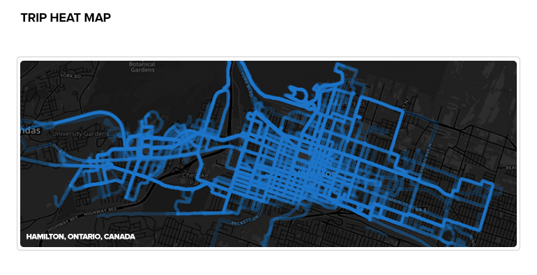