After decades of stonewalling efforts to make neighbourhood streets safer, the Public Works Department finally seems to be taking complete streets seriously.
By Ryan McGreal
Published August 13, 2014
Over the past decade, the City of Hamilton has not had a good track record for attention to pedestrian safety and accessibility. Instead, the City's top priority for public streets has been maximizing the speed and volume of automobile traffic by overbuilding lane capacity and engineering streets for illegal speeding, even though automobile traffic volumes in the lower city have been going down.
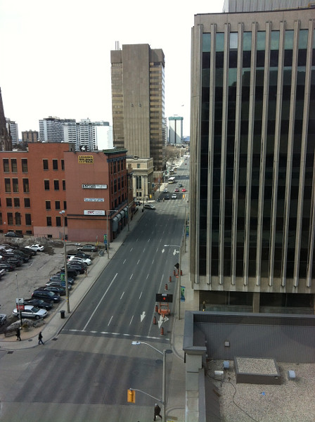
Main Street, view from John Sopinka Courthouse at 1:30 PM on a weekday (RTH file photo)
One predictable result is that Hamilton has become the second most dangerous city in Ontario for pedestrians. Pedestrians are 42 percent more likely to be injured in Hamilton than the provincial average, and Hamilton cyclists are 81 percent more likely.
The good news is that this is starting to change. The City has finally noticed that we have excess lane capacity that should be put to better use, and Council recently approved a Pedestrian Mobility Plan in which making streets complete and inclusive becomes a matter of "routine accommodation" rather than an optional add-on that can easily be nixed.
After decades of stonewalling grassroots efforts to make neighbourhood streets safer, the City's Public Works Department went on a crosswalk-repainting spree last summer, which it has continued this year.
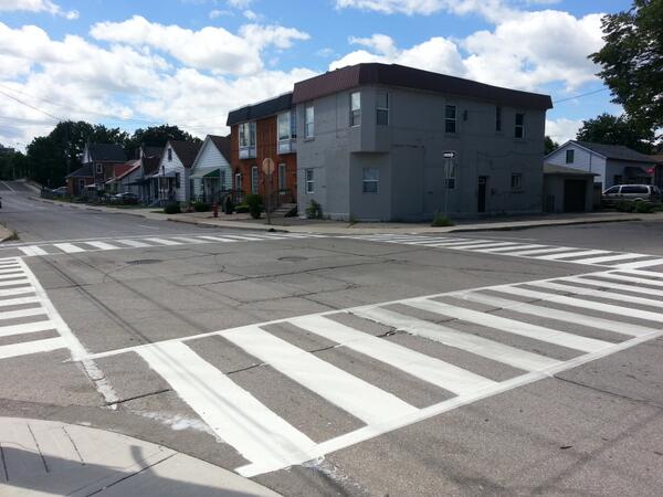
Zebra crossing at John Street North and Simcoe Street (RTH file photo)
After a spate of pedestrian collisions on Queen Street earlier this year, the Traffic Department agreed to undertake a traffic safety review.
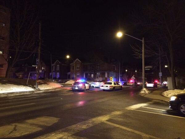
Police block Herkimer at Queen on March 7 (Image Credit: Andrew Spearin)
David Ferguson, Superintendent of Traffic Engineering, completed the review in June. Ferguson noted that Queen Street has had 19 collisions involving pedestrians over the past five years, all of which occurred at intersections. He made the following recommendations:
Review side streets for crosswalk installation. Queen has a lot of pedestrian activity, but most cross streets are uncontrolled.
Increase crossing time at signalized intersections. The city has traditionally timed cross signals based on a walking speed of 1.2 m/s, but has set a new standard of 1.0 m/s, which will make it easier for senior citizens and young children - who are disproportionately at risk of vehicle collisions - to cross in time.
Pay special attention to Queen and Main. 39 percent of the collisions happened at this intersection, which is in the top 20 across the city for pedestrian injuries. One measure has been to install zebra (or ladder-style) crosswalk markings on the north and west leg of the intersection.
Enhanced ladder crossings at several locations. The City has already installed ladder crossings at Queen and Hunter, which, in addition to the green-painted bike box at the end of the Hunter Street bike lanes, have increased the active transportation profile of the intersection.
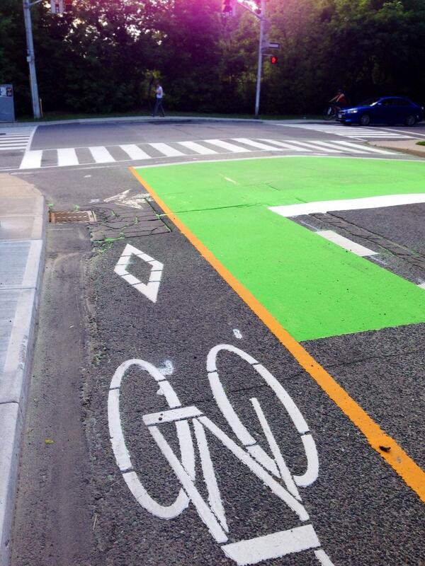
Hunter and Queen (Image Credit: Jason Leach)
Ferguson noted that the Province is in the process of updating the Ontario Traffic Manual, Book 15, and that the new manual will include tools that municipalities can use to enhance pedestrian crosswalks. It defines four types of crosswalk control: a school crossing guard, Stop or Yield sign, Pedestrian Cross-Over (PXO), and traffic signal.
The City of Hamilton decided against using PXOs in 2002, citing evidence from Toronto that they had a poor safety record. A City of Toronto Pedestrian Collision Study [PDF] from 2007 noted:
The driver's visibility of the traffic control device (PXO), the driver and pedestrian's understanding or lack thereof of how a PXO operates, and the pedestrian's false sense of security at PXOs. Both drivers and pedestrians may not be aware of the laws that govern driving and crossing at a PXO.
The study noted that Toronto approved a plan to replace 61 PXOs with signalized crosswalks and upgrade another 269 PXOs to make them more visible and safe.
In December 2012, Hamilton Traffic Engineer Ron Gallo wrote in an email response to RTH that the Traffic Department prefers to install pedestrian-activated crosswalks:
I would advise against the use of PXOs regardless of road class due to the confusion they cause. The intent is the same so why not use the safer and better understood option?
Crosswalks are safer but they're also a lot more expensive, with the result that fewer intersections have received any kind of controlled crossing. The few signalized crosswalks that have been installed recently have been funded from the respective ward's area rating capital fund.
However, the new Ontario Traffic Manual defines four distinct types of PXO (type A through D), identified by regulatory and warning signs, flashing amber beacons and pavement markings and specified for use in particular street contexts (number of lanes, one-way or two-way, mid-block or intersection, low-, medium- or high-volume, distance from other crossealks, etc.).
These new PXOs have been redesigned for greater safety and recommended for use in appropriate contexts, based on the safety evidence from the old PXOs.
Hamilton's Traffic Department is also considering the use of so-called 'Courtesy Crossings', or uncontrolled crosswalks, at selection locations. In 2002, the City quietly stopped maintaining uncontrolled crosswalks, allowing the painted markings to fade away on the grounds that they were not as safe as controlled crosswalkes (yet doing nothing to improve their safety, either).
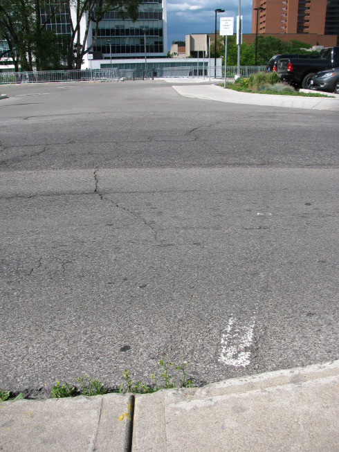
'Ghost crosswalk' on Hunter Street at Park Street, right behind City Hall (RTH file photo)
Traffic staff are working on a new Courtesy Crossing program that can be implemented once the new Ontario Traffic Manual comes into effect.
An early suggestion, unfortunately, was to include a sign warning pedestrians that motorists don't have to stop for them - which is just wrong.
However, staff more recently clarified that the design is not yet finalized so there is still hope that it won't include the dangerous and misleading sign.
Meanwhile, the City has at least started repainting existing uncontrolled crosswalks. However, it seems clear that most drivers don't know - or don't care - that they are obligated to yield to a pedestrian who is trying to cross. Pedestrians, in turn, must wait for a gap in traffic big enough that drivers have time to yield.
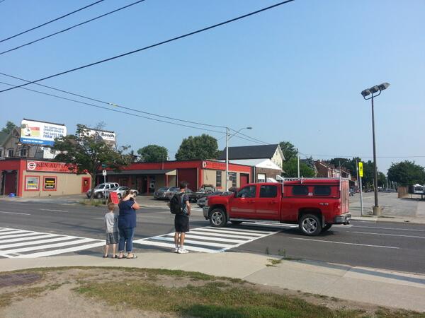
Family trying to cross Cannon Street at Elgin (RTH file photo)
This Thursday's Public Works Committee meeting includes a staff recommendation to re-establish a Strategic Road Safety Program.
The road safety initiatives would be funded via surplus revenue from the city's Red Light Camera program, including hiring a Senior Traffic Safety Technologist on a three-year contract to implement the program. The program would start with $545,000 from the Red Light Camera Reserve to fund 2014 initiatives.
Included in the program would be the new pedestrian crossing initiative, which will follow the Ministry of Transportation's new guidelines to establish "new pedestrian crossing locations" and focused education on drivers, cyclists and pedestrians.
The program will also review the city's existing speed limit policy. Currently, the unsigned speed limit on Hamilton streets is 50 km/h, a speed that applies to major arterials and residential side streets alike.
Cities around the world - including Bristol and Edinburgh - are adopting lower speed limits as part of a global "Vision Zero" campaign to eliminate preventable deaths from automobile collisions by redesigning streets to be inherently safer.
Hamilton's North End Neighbourhood is undertaking a five-year pilot project to have 30 km/h speed limits on most streets (excepting James North and Burlington Street), encouraged through various traffic calming measures, including zebra crossings and bumpouts. Unfortunately, the pilot comes with a strict five-year moratorium on establishing similar limits in other neighbourhoods.
The Strategic Road Safety Program will also focus on safety measures and education for the most vulnerable road users, specifically children and senior citizens, who are disproportionately the victims of pedestrian collisions.
The original Strategic Road Safety Program was established in 2007 with the goal of reducing fatalities, injuries and property damage by 10 percent a year from 2009 to 2012. However, the program was effectively disbanded in 2009, and collision injuries/deaths did not decline during the period between 2006 and 2012.
| 2006 | 2007 | 2008 | 2009 | 2010 | 2011 | 2012 | |
|---|---|---|---|---|---|---|---|
| Total Collisions | 3202 | 3378 | 3316 | 3337 | 3677 | 3755 | 3644 |
| Fatalities | 22 | 21 | 14 | 14 | 20 | 17 | 19 |
| Alcohol related | 231 | 222 | 235 | 195 | 181 | 189 | 155 |
| Vulnerable Road Users: Cyclists | 147 | 157 | 162 | 139 | 163 | 149 | 161 |
| Vulnerable Road Users: Pedestrians | 225 | 286 | 243 | 213 | 263 | 267 | 261 |
| Intersections | 1709 | 1829 | 1765 | 1661 | 1867 | 1805 | 1853 |
| Segments | 1493 | 1549 | 1551 | 1676 | 1810 | 1950 | 1791 |
| Rural roads | 1160 | 1158 | 1184 | 1194 | 1214 | 1225 | 1254 |
The staff report recommending restarting the program argues that "a more active road safety program is needed to further improve safety conditions for all road users."
The preventable deaths and injuries that go along with traffic collisions are extremely costly. The average collision in Ontario costs $77,000, with a major injury costing as $280,000 and a fatality costing $13.6 million.
Suddenly some white paint and $80 knockdown bollards don't sound so expensive after all.
By Pxtl (registered) - website | Posted August 13, 2014 at 10:32:12
I'm disappointed that two-way conversion was apparently completely left out of the city staff's discussion of these issues. Of all the century-ish-aged parts of Hamilton, only the old core has this problem.
You don't see this kind of trouble in old Stoney Creek, or Dundas, or Ancaster, or Westdale. And the common difference is that they're all two-way. Two-way Queen would solve so many problems.
I like that they're repainting crosswalks, but I suspect that city staff may be simply using it for the illusion of progress in lieu of actually making hard decisions of traffic flow.
By ItJustIs (registered) | Posted August 13, 2014 at 10:56:29
How a discussion is framed can make an enormous difference. Even if it doesn't seem that way to an observer. (Usually expressed by them in terms of 'splitting hairs'.) 'God/The Devil is in the details'.
'Reversion', not 'conversion'.
I've always been surprised that this fact is rarely raised by those to point to past mistakes, wishing for bygone days, bemoaning what 'used to be'. It's a shame it's been ignored.
Comment edited by ItJustIs on 2014-08-13 10:56:42
By jason (registered) | Posted August 13, 2014 at 11:10:56
I agree there is lots of potential with these new tools, but will refrain from being optimistic given the first draft of the courtesy crossings was so ridiculous.
Was in Port Elgin and Southampton, ON for vacation this summer and they have Ped X crossings in both towns. All the cottagers from Hamilton had no problem obeying the flashing beacons. And if you've seen the new ones in Toronto they have lights that shine down onto the crosswalk at night illuminating it and making it very visible.
In fact, a week in Sauble Beach, Port Elgin with all the McMaster sweater-wearers, Hamilton car dealer license plate frames and meeting person after person from the Hammer and yet everyone drove safe with all the bikes sharing the road, kids were riding all over town, ped x crossings were obeyed. We aren't idiots in this city. We just drive like it because our roads are engineered to encourage it.
By CharlesBall (registered) | Posted August 13, 2014 at 13:41:04
I am curious about your statistics. A lawyer friend of mine told me years ago that death cases are usually the less expensive for insurance companies. The Ontario Court of Appeal upheld a ruling in a case called To that the highest award granted for the death of a child for a single parent was $100,000.00 (at that time.) Economic losses are higher for wage earners but she insisted that by far, fatality cases are less costly than serious injury cases. Could you quote the stats as I am interested in that?
Comment edited by CharlesBall on 2014-08-13 13:43:08
By kevlahan (registered) | Posted August 13, 2014 at 13:56:25 in reply to Comment 103925
I think Ryan was not referring to the cost of insurance claims, but to the total estimated social cost. For example, see this Transport Canada study from 2007:
http://www.tc.gc.ca/media/documents/road...
Across all collision severities the average social cost of a collision in Ontario in 2004 was $77 thousand. By major consequence of collision the average full (including all allocated) social cost was:
• Fatality — $13.6 million.
• Major injury — $280 thousand
• Minor injury —$48 thousand.
• Minimal injury — $18 thousand.
and overall
Motor vehicle collisions generated $18 billion in social costs in Ontario in 2004. Fatalities in those collisions were the largest single contributor to social costs at $11 billion.
Comment edited by kevlahan on 2014-08-13 14:02:21
By Anon (anonymous) | Posted August 13, 2014 at 22:38:36
There is a motion at this Thursday's Public Works Committee to reduce a speed limit from 80 to 60 kilometres per hour on Miles Road. It could be an interesting precedent.
By Pxtl (registered) - website | Posted August 15, 2014 at 01:01:59 in reply to Comment 103936
Miles Road? Is there new development out there? Because that seems like a random farming highway.
By Anon (anonymous) | Posted August 14, 2014 at 21:14:32 in reply to Comment 103936
The motion passed and should be ratified at tomorrow's city council : I just spoke with Ms Leduc, Public Works Committee's Legislative Assistant.
By jason (registered) | Posted August 14, 2014 at 19:36:31
Noticing at tomorrow's council meeting, new bike lane designations:
The 2nd and 3rd lane from the west curb of Bay St, north of Cannon. The 2nd lane from the curb will become a bike lane leading west on the Cannon bike lanes. It says the 3rd lane from the curb will become a bike lane leading east on Cannon. Not sure if this means two entire car lanes, or one car lane being replaced with a two-way bike lane.
Hess St northbound, the east curb lane from York to Cannon
Charlton Ave from James to Locke, the north curb becomes a bike lane Herkimer from Locke to James the south curb lane becomes a bike lane.
Not sure of timelines for the last two.
By StephenBarath (registered) | Posted August 15, 2014 at 08:11:36 in reply to Comment 103961
I don't get that. Charlton between Locke and Dundurn would be more accomodative of a bike lane than Charlton east of Locke. It's four hundred meters or so between Locke and Dundurn- why would (hypothetical) bike lanes on Charlton and Herkimer not continue those four hundred meters, particularly when Dundurn has bike lanes?
By Pxtl (registered) - website | Posted August 15, 2014 at 00:38:34 in reply to Comment 103961
Oooh, exciting.... wait.
https://mapsengine.google.com/map/edit?m...
I hate to bag on bike lanes, but did they actually ask anybody about these? Who the heck is this supposed to help? I mean, the Herkimer and Caroline ones make sense if your'e going to continue the ludicrous concept that those streets need to remain one-way, but the Bay Street ones? Has anybody at city hall ever tried biking west from York at Bay? Being able to go north isn't the problem, south and west is. They proposed 2 new lanes to interact with the new Cannon Bike lanes and managed to solve a sum total of zero east/west commuter problems. Bay to Queen is still a giant dead freaking end for westbound cyclists, unless they want to go ride on Queen and, y'know, die. They start the Bay Street lane north of York where it doesn't help anybody trying to bike up from Market Street or Downtown.
Every day I see other cyclists on my morning and evening commute, and every day I see us all breaking the same laws. Cheating our way from York at Bay to Napier, or going eastbound through Napier at Queen (which is illegal because reasons).
Give me a stop light at Queen and Napier and a 2-way Bay (or Hess, I guess, once Cannon is done) and I don't care what other bike lanes you build.
You must be logged in to comment.
There are no upcoming events right now.
Why not post one?