We could reduce our costs by eliminating unnecessary infrastructure so that we no longer have to pay to maintain it. But the City seems to build and replace infrastructure as an automatic process, not according to what we actually need.
By Sean Burak
Published September 10, 2013
I've been writing for some time about Hamilton's big and growing problem with its infrastructure deficit. We've got a lot of infrastructure to maintain, and every year we fall tens of millions of dollars short in doing necessary maintenance on it.
One really easy way we could reduce our costs is to eliminate unnecessary infrastructure so that we no longer have to pay to maintain it. But the City seems to build and replace infrastructure as an automatic process, not according to what we actually need.
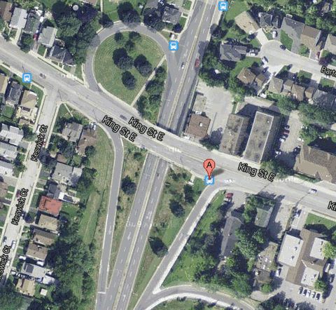
Here's a case in point: the King Street East bridge over Kenilworth Avenue South was in a state of disrepair so the City decided to replace it - a project budgeted at $2.3 million.
It's designed like a highway, with a separated-grade crossing, complete with exit ramps. But King and Kenilworth is just an intersection of two city streets. Does the traffic volume justify this very expensive piece of infrastructure?
I contacted Councillor Sam Merulla to ask him, and he responded that the city is replacing something that's already there, and that it's on the truck route. "It is redundant to ask whether the bridge is redundant."
I pointed out that lots of streets - like Main and Kenilworth just a few blocks away - are also on the truck route and don't have highway-style overpass bridges.
If King at Kenilworth needs an overpass, why don't all the other intersections on the truck route? If we can agree that it would be lunacy to build an overpass at Main and Kenilworth, why does it seem normal and acceptable at King?
I also asked what process was used to determine that the bridge had to be replaced, instead of some other cheaper option.
Councillor Merulla forwarded a reply from Gary Moore, the City's director of engineering services in Public Works. Moore's reply is interesting. He said "there was no previous recommendation for the removal of the interchange or implementation of an intersection or requests for any change to the traffic patterns noted in any current Transportation Master Plan approved by Council."
Moore suggested that turning King and Kenilworth into a normal intersection "would have required the removal of several homes, extensive re-grading of King Street and would have required a full Environmental Assessment study to be undertaken."
He noted that the infrastructure replacement was partial (bridge deck and pier only) and had to be done quickly "due to condition and traffic requirements".
Main and King each carry around 20,000 vehicles a day across Kenilworth, but while there are only 14,000 vehicles a day on Kenilworth at Main, there are 26,000 vehicles a day on Kenilworth just south of King. Moore wrote, "This reflects the large volume of turning movements from Kenilworth to King and Lawrence, facilitated by the free flow movement of the interchange configuration."
Moore concluded: "Given that we already had the higher level of safety and service provided by the King/Kenilworth Grade separation and that it is more economical and expedient to simply replace the deck, no other options were considered practical or affordable."
I don't want to come across as confrontational - this isn't an attack on either Councillor Merulla nor on the staff involved. I'm also not an expert in urban planning, so I don't want this to be taken as an attempt to change the design of this specific piece of infrastructure.
I am, however, an engineer, a planning enthusiast, a Hamilton lover, and a taxpayer. I think that this project is a clear indicator of some serious problems with the processes within the city and specifically with Public Works.
The roads budget is over $100 million for 2013, and Public Works claims that we are falling behind rapidly: "Annually, the City should be spending approximately $179 million on road and bridge repair." So this year we are simply not going to complete over 40 percent of what Public Works deems "necessary" because we simply don't have the money.
Raising taxes to cover this shortfall is not feasible. So that leaves one other option - reduce the "required" expenditure.
Here we have a situation where we've undertaken a substantial infrastructure project that the traffic numbers clearly show is not truly necessary. The City's knee-jerk reaction is that, for traffic flow and public safety, there was no way not to do it.
I agree we couldn't simply ignore this bridge. But we could have - and should have - looked at alternatives before dropping this cash.
Meanwhile, when I ask for the actual data, there is a delay because it appears that there was never any study completed. It had to be whipped up after the fact. So if there was a better, cheaper option, we never even had a opportunity to find out about it.
Public Works says that Council never directed them to change the traffic pattern. But Public Works never advised Council that it might be wise to revisit the design.
Council (understandably) follows Public Works' recommendations when it comes to traffic engineering. Isn't it the traffic engineers' responsibility to advise council on these things? Isn't that half the reason we pay them? How is council supposed to know that there might be a better, less expensive option if Public Works doesn't tell them?
Basically, it appears that it is never anyone's responsibility to ask, Should we be replacing this infrastructure as-is or should we investigate less expensive alternatives?
Multiply this "blind replacement" policy across every project in the city, and we end up with a totally out-of-control infrastructure deficit.
Another example: Claremont Access. Have we done a traffic study there to determine how many lanes we need? Because propping the mountain back up in order to open that third downbound lane certainly borders on lunacy for a city whose infrastructure budget is a billion dollars behind and falling by $80 million a year.
We just repaved four lanes on King Street - at what cost? A traffic engineer should look at that street and determine that we only need one or two lanes (the numbers prove this).
")
King Street East, recently repainted (RTH file photo)
If we eliminated just one lane, then we'd save 25 percent on that project every single time it's repaved. It's very basic engineering math, and we must start doing these calculations if we are ever going to pull ourselves out of this hole.
Somebody needs to take a hold of this problem - and fast. Who will it be? If you want to start saving taxpayers' money, this is where you need to look.
I'd like to make a few more comments about King and Kenilworth. Again, this is an exercise in using it as an example, rather than an attempt to get the project changed. I know it's too late for that, but I want to make sure we understand what is happening here.
First of all, 20,000 cars a day is peanuts. It's on the high end of "road diet" territory, meaning King would survive nicely as a one-lane-in-each-direction street.
Neither King nor Kenilworth is a major business route. There would be no disruption to economic activity if changes were made. There is certainly no need for a grade-separated interchange with ramps.
We are currently surviving quite comfortably with no intersection at all - i.e. zero throughput! And this during the busiest traffic season. None of the alternative side streets are clogged.
I commute this every day during rush hour and the line-ups range from zero to ten cars - and that's at a four way stop in a residential neighbourhood that drivers are re-routed through. And we are to believe that a full-fledged overpass here is justified by traffic numbers?
Many of Mr. Moore's comments are frankly bizarre. I have to wonder if he's ever been to the corner in question.
The complete removal of the King Street overpass and reintroduction of an at grade intersection would have required the removal of several homes.
How could he know this when there was never a study done? I visit this intersection daily and I am sure that no homes would have to be removed. I'm curious, in fact, about which buildings were built later than the overpass?
An at-grade intersection takes up a lot less space than an overpass with on-ramps. To revert to previous mode, we all of a sudden need more room than we did back when these homes were built around what was originally an at-grade intersection?
Given that this is a partial replacement of the structure (Deck and Pier only), and given that it needed to be done in relatively short time frame due to condition and traffic requirements, it is the more financially feasible scenario.
Again, without a proper study, this is just a guess. How much would it have cost to bring back an at-grade crossing? What would the ongoing costs of maintenance be of a bridge versus a basic traffic light? We don't actually know these numbers.
The reintroduction of an intersection type of change in design would also have had a major impacts with the other two overpasses
I invite Mr Moore to visit the intersection. Both of those overpasses are at a significantly higher elevation than King Street. Look at the Google StreetView from from underneath the closest overpass.
You can see how Kenilworth has been graded down to go under King, and there is a lengthy approach to work with for regrading, not to mention an enormous width that clearly shows that there would not need to be houses removed.
In fact, I am willing to bet that an at-grade intersection would create an opportunity for the city to put new commercial corner lots onto the property roster and maybe get a bit more tax income!
extensive re-grading of King St.
King and Kenilworth once crossed at the same grade. Yes, there might be some regrading of King - but it would not necessarily be "extensive" as it would appear that most of the regrading that happened when the overpass was initially installed was a lowering of Kenilworth.
we already had the higher level of safety and service provided by the King/Kenilworth Grade separation
This bridge actually offers abysmal service. From King, drivers can only access Kenilworth southbound. From Kenilworth, cars can only access King eastbound - and only from the northbound lane. This is "higher level of service"?
A standard intersection offers 12 "movements" (each of the four directions allows you to go straight, right or left). But this overpass only offers seven movements. So 7/12 options for drivers is a higher level of service?
The reason I bring all of this up is because this staff response basically amounts to making up reasons after the fact. The only valid information we can glean from their response is that there was no study done beforehand. That means is we simply don't know what the options would have been, nor their costs.
We need to ask why they didn't at least wonder about alternatives. Our economic sustainability depends on Public Works being mandated to ask "should we" when it comes to infrastructure replacement.
Too often, we just build (or rebuild) it because no one stops to ask if we actually need it.
By engineer (anonymous) | Posted September 10, 2013 at 11:55:52
As an engineer, in the traffic/highway design field, I wholeheartedly agree with Gary Moore's comments. To say that some of his comments are bizarre is surprising. You claim that you're an engineer (in what field?), so you should be aware that engineering judgement based on extensive experience is key and that full studies do not need to completed for everything. No offense, but I trust Mr. Moore's assessment of the site more than yours when it comes to regrading requirements and property impacts if an at-grade intersection were to be introduced. In addition, you'd be surprised how much the reconstruction of this area to an at-grade would cost...with removal of the existing structures and such.
I'm not too familiar with the municipal class EA, but I'm assuming some level of public consultation would have been completed for this major rehabilitation...that would have been the time to address these concerns. Not now that it's under construction.
By observator (anonymous) | Posted September 11, 2013 at 16:12:18 in reply to Comment 91940
note to self: gary moore reads raisethehammer
By seancb (registered) - website | Posted September 11, 2013 at 11:56:10 in reply to Comment 91940
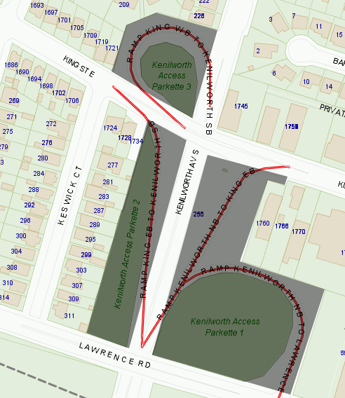
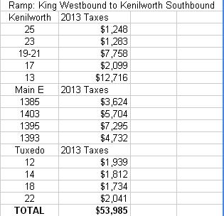
Just for fun, I took some map overlay shots comparing the land use requirements for King/Kenilworth vs Main/Kenilworth. I also did some land value math.
tl;dr version: First, it's clear that we could actually have more properties closer to the intersecton if we didn't have ramps. Second, I approximate that the tax value of the land used up by the Kenilworth/King/Lawrence ramp system could be a quarter million dollars (meaning we give up 250,000 of tax income every year).
Before I get into the details, I will freely admit that there is no way to accurately tell the exact value of what properties could exist on this land if it were regraded. But we know it's generating zero tax revenue now, is actually costing us money, and the parcels are large enough that we could reasonably expect that a commercial or multi-unit residential developer might be attracted to shovel ready land here. So it's worth at least considering that there is value here.
But on a grander scheme, this exercise puts a numerical value on the land we are wasting on unnecessary pavement throughout the city.
First, an animation showing a comparison of the land required for King/Kenilworth versus Main/Kenilworth:
Here is the city tax map of King/Kenilworth. I shaded the areas used up by the ramps:
And here is Main/Kenilworth underneath the same shading:
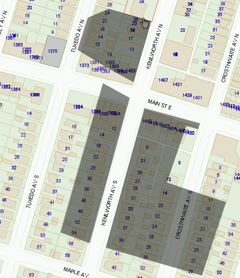
And here are the calculations of all of the properties at Main/Kenilworth that would fall under the shaded area (i.e. would need to be removed from tax rolls if we decided to build the same ramp system there):
Comment edited by seancb on 2013-09-11 12:01:00
By TB (registered) - website | Posted September 13, 2013 at 08:38:50 in reply to Comment 92021
Outstanding piece of work. Isn't this what our traffic engineers are paid to do?
By seancb (registered) - website | Posted September 13, 2013 at 10:00:51 in reply to Comment 92119
You'd think so. This took me about an hour using tools available to the public and I was paid zero dollars. Imagine what should be possible from within the city using ALL of their data by someone actually being paid to do it!
The replacement of the existing bridge deck on King Street over the Kenilworth Access was undertaken as the preferred course of action as there was no previous recommendation for the removal of the interchange or implementation of an intersection or requests for any change to the traffic patterns noted in any current Transportation Master plan approved by Council. The complete removal of the King Street overpass and reintroduction of an at grade intersection would have required the removal of several homes, extensive re-grading of King St. and would have required a full Environmental Assessment study to be undertaken. Given that this is a partial replacement of the structure ( Deck and Pier only), and given that it needed to be done in relatively short time frame due to condition and traffic requirements, it is the more financially feasible scenario. The reintroduction of an intersection type of change in design would also have had a major impacts with the other two over passes, located over Kenilworth just south of King Street for both Lawrence Road and the Canadian Pacific Railway crossings.
A review of the most recent traffic count information available for this area indicates that both Main and King streets carry a similar daily traffic volume of approximately 20,000 vehicles per day across Kenilworth Avenue. However there are approximately 14,000 vehicles per day recorded on Kenilworth at Main Street, compared with approximately 26,000 vehicles recorded on Kenilworth, just north of the traffic circle (Kimberly Drive). This reflect the large volume of turning movements from Kenilworth to King and Lawrence, facilitated by the free flow movement of the interchange configuration. It should also be noted that fewer traffic collisions occur at "separated grade crossings" such as King Street over the Kenilworth Access, compared to "at grade" signalized intersections such as Main Street & Kenilworth Avenue.
Given that we already had the higher level of safety and service provided by the King/Kenilworth Grade separation and that it is more economical and expedient to simply replace the deck, no other options were considered practical or affordable. We trust that this information is of assistance.
Gary Moore, P.Eng Director Engineering Services Public Works Department
By AnjoMan (registered) | Posted September 11, 2013 at 10:07:07 in reply to Comment 91940
Engineer here. Even if you use common sense and experience to evaluate a project, you would still do it before the project was completed and you would write it down in a report with a proper assesment. The fact that Gary Moore's experience is available to Public Works does not in any way remove the requirement that actual study and calculation be done. Engineering 'experience' is about knowing what aspects of the project need to be looked at and addressed. Its not a matter of just knowing how the analysis would work out. You still do the analysis, even if you are an experienced engineer.
I'm assuming some level of public consultation would have been completed for this major rehabilitation...that would have been the time to address these concerns.
This is the whole point of the article - there is no evidence that any analysis was done before hand. You're assuming that analysis was done, while the author of this article is assuming that it hasn't been done based on the fact that no real analysis was produced. Its not about 'public consultation' (asking the neighbors) even, its about doing the basic observations and math to see what is the best course of action. A good engineer would justify their choice with more than just a hand-wavy explanation after the fact. If public works had done the analysis they could just produce a report explaining the design choices and we would say 'Ok, you clearly asked the right questions and came to a sensible conclusion'. Where is that report?
Comment edited by AnjoMan on 2013-09-11 10:13:36
By Kyle T (anonymous) | Posted September 10, 2013 at 12:54:05 in reply to Comment 91940
"No offense", but you have clearly not visited the site either. There was no "assessment of the site". Full studies do not need to be completed for everything, but a single visit to the site is enough to warrant a study. At present, only one property is anywhere near Kenilworth, and removal of the overpass would only serve to increase the distance of that property to Kenilworth.
Also, we are not talking about "an at-grade intersection being introduced". That would imply the intersection has always been as it is now. We are talking about RESTORING an at-grade intersection.
By Pxtl (registered) - website | Posted September 10, 2013 at 13:02:52 in reply to Comment 91949
I think his point is mostly that there would be tremendous cost associated with simply re-grading the ground, regardless of whether or not the current layout is "natural" or not.
By seancb (registered) - website | Posted September 10, 2013 at 12:08:52 in reply to Comment 91940
I did not claim to be a traffic engineer and explicitly stated that in my commentary. The greater point is that we didn't even think to look at other options. A city that is sinking in an infrastructure deficit faster than it can bail needs to be a bit more aware of how the money is being spent. This isn't filling in potholes or replacing sidewalks. This is a relatively major project for which alternatives were never even considered.
As an engineer in the traffic/highway design field, would you build an overpass at two roads that cross - one carrying 20,000 VPD and one carrying 26,000?
edit to add: I just expect engineers to lean more toward the problem solving/critical thinking side of things. We have a huge PW spending problem, and we need our traffic engineers to be solving it. The problem is not going to go away by itself.
Comment edited by seancb on 2013-09-10 12:18:19
By engineer (anonymous) | Posted September 10, 2013 at 13:35:45 in reply to Comment 91943
Sure - why not? Grade separations have been recommended in locations with much less traffic. It's not always about volumes...safety needs to be considered (as Gary Moore has stated), and also the actual operations. Without knowing the actual turning movements and distribution/direction of traffic, it's hard to say if an at-grade would even work. So what's better...the existing configuration, or an mammoth intersection with dual left-turn lanes? That's not good for other road users such as cyclists and pedestrians.
By lefty (anonymous) | Posted September 12, 2013 at 08:54:55 in reply to Comment 91961
funny you mention left turn lanes because there's only one left turn available to drivers with the current config. so this mammoth intersection you are describing is also overkill.
"sure, why not" - is that the traffic engineer motto?
By seancb (registered) - website | Posted September 10, 2013 at 13:53:42 in reply to Comment 91961
The overpass is already not good for other road users such as cyclists and pedestrians. It serves 2 users well - drivers on king who want to go up the Kenilworth access, and drivers on Kenilworth who don't want to stop at King - at the cost of all others.
I think it's disingenuous to say we don't know if an at-grade "would even work". Of course it would. What we don't know is what an at-grade there would need to look like. Because we don't know any of the answers to the "movements" questions. Because our engineering department did not bother to find out.
By Keith (anonymous) | Posted September 10, 2013 at 13:11:34 in reply to Comment 91943
How much volume did that intersection carry when it was built? It's easy to say 'in retrospect' but at the time it may have been warranted.
By Jeff Neven (anonymous) | Posted September 10, 2013 at 12:38:28
The other miss on this project is consideration for the LRT. Once Main get's an LRT (I know, I can hear some of you laughing), you won't be able to head east on Main and turn north on Kenilworth. More reason than ever to change the intersection now to allow vehicles to go east on King and turn north on Kennilworth.
By Pxtl (registered) - website | Posted September 10, 2013 at 14:17:54 in reply to Comment 91945
Isn't the hypothetical LRT going on King, or is it on Main through that area?
By Kyle T (anonymous) | Posted September 10, 2013 at 12:38:35
As a resident directly impacted by the redirected traffic, I can attest that the traffic routed through my neighbourhood is a nuisance, but it can by no measure be considered “high volume”. Much of the redirected traffic is moving just fine on side streets with multiple stop signs. The south-bound traffic is also moving just fine on the single lane to which it has been reduced. The east-bound traffic has also seen little-to-no backup despite being funneled to a single lane (the detour to south-bound Kenilworth and subsequent return to King).
There are absolutely no indications that King Street requires any special traffic considerations like an overpass.
I am extremely disturbed by the following statement.
"Given that this is a partial replacement of the structure ( Deck and Pier only), and given that it needed to be done in relatively short time frame due to condition and traffic requirements, it is the more financially feasible scenario."
The disturbing part is the implied “short-term” with respect to “financially feasible”. There is absolutely no way that, long-term, the continued maintenance of the overpass is the “more financially feasible scenario”. It is absolutely irresponsible that the long-term financial repercussions are not duly considered.
The other disturbing point made is the following.
"we already had the higher level of safety and service provided by the King/Kenilworth Grade separation "
Does the “safety” consider the “Speed Kills” sign that has been in place on the rail bridge for as long as I can remember? Does it consider the nearly weekly police speed trap set up at Normandy and Kenilworth? Does it consider that neither King and Kenilworth nor the first intersections east and west of Kenilworth have safe crosswalks? With the overpass, there is nothing slowing cars down at this intersection. Pedestrians are expected to make a mad dash across King Street, sometimes having to pause on a thin strip of median.
No. Long-term financial feasibility was never a consideration, nor was safety.
By seancb (registered) - website | Posted September 10, 2013 at 14:05:52 in reply to Comment 91947
Stopping bike lane development would be a great way to save money - if it was actually costing us anything. Of the 100 million roads budget, something like 600,000 is set aside for bike infrastructure. So for every 1000 we spend on bike lanes we are spending 166,000 on roads. 0.6%.
Not to mention the fact that maintenance and replacement costs for bike lanes and sidewalks are significantly lower than for driving lanes.
This one project is costing us 3 times what we're spending all year on bike lanes.
There is no way to possibly spin these numbers to show that alternative transportation costs are sinking this city.
We can't afford this many car lanes. The sooner we all accept this truth, the faster we'll get our budget under control.
By AlHuizenga (registered) | Posted September 10, 2013 at 13:28:12 in reply to Comment 91947
Hey (Gas-Powered) Transportation Guy:
If the cost of maintaining your car infrastructure is way more than you can afford, and if you have way more car infrastructure than you can possibly use, and if you have a massive deficit of reasonable cycling and pedestrian infrastructure (even though that kind of infrastructure is much cheaper and promotes a much healthier city)...in what sense has your infrastructure "worked for years?"
And if you really think that it makes more sense to maintain and repair that unaffordable, redundant, and city-harming car infrastructure than it does to invest in affordable, badly needed, city-improving cycling and pedestrian infrastructure, what does that say about your critical thinking skills?
By Transportation Guy (anonymous) | Posted September 10, 2013 at 13:55:55 in reply to Comment 91958
By AnjoMan (registered) | Posted September 11, 2013 at 10:15:54 in reply to Comment 91964
leans more towards a driving city
FTFY
By Kevin Love (anonymous) | Posted September 10, 2013 at 20:07:57 in reply to Comment 91964
Which is why car-free urban areas are all just burning right down to the ground. Toronto Islands? One big cinder. The car-free downtown of virtually any Dutch city? All a burning heap of rubble.
It is easy to make fun of such ignorance. It is disturbing that the ignorance is out there in the first place.
By Kyle T (anonymous) | Posted September 10, 2013 at 17:10:08 in reply to Comment 91964
I'm glad you mention fire trucks. Right now, the fire trucks have to drive south on Kenilworth (where the station is located), turn onto Normandy, turn onto Cameron, then get to King Street. While they don't need to stop, they indeed pause at multiple stop signs through this route.
As for "choking off the car infrastructure", please refer to my earlier comment. There have been no significant backups or traffic slow-downs, even during rush hour, despite all four directions essentially being routed through single-lane channels with multiple stop signs. We are paying 2.3 million on a bridge that doesn't need to exist. We might have had to pay 4 million to get rid of the bridge, but at least it means we don't have to pay another 2.3 million down the road.
By jason (registered) | Posted September 10, 2013 at 14:39:54 in reply to Comment 91964
Lol
By kevlahan (registered) | Posted September 10, 2013 at 14:11:42 in reply to Comment 91964
So, there are no grocery stores or fire services in dense pedestrian friendly cities like Vancouver, Paris or New York? Commerce and trade are chronically weak in London and Copenhagen?
There are actually police stations on pedestrian streets in Paris for goodness sake! If economically vibrant cities like Vancouver or Paris or New York are "able to conduct commerce and trade" (far better than Hamilton) we certainly don't have to worry about two-way conversions or cycle lanes harming ours. Quite the opposite.
No one is saying that all streets would be closed to traffic, just that the costs of maintaining an under-used highway style design for urban city streets are high and the options for reducing these costs have not been investigated. The traffic department themselves acknowledge that almost every arterial and minor-arterial is way under capacity and that traffic has declined significantly in the last few decades.
And just to illustrate how wrong the "free flowing motor vehicle traffic = economically dynamic" argument is, as pointed out in a previous article downtown Vancouver has invested heavily in pedestrian and cycling infrastructure as well as increased transit and has simultaneously seen a huge growth in population and a decrease in motor vehicle traffic. And it consistently ranks among the top cities in the world on livability indexes.
Comment edited by kevlahan on 2013-09-10 14:31:19
By Transportation Guy (anonymous) | Posted September 10, 2013 at 15:10:51 in reply to Comment 91970
So when your cost of living rises to the level of those cities, you'll now know why.
By AnjoMan (registered) | Posted September 11, 2013 at 10:19:06 in reply to Comment 91988
In those cities, you pay for value. In your vision of Hamilton, you will pay for rot.
By Steve (registered) | Posted September 10, 2013 at 15:59:23 in reply to Comment 91988
Hahaha, nothing like throwing around some FUD. Did you keep a straight face when you typed that one? Hamilton equaling the cost of living in Vancouver, Paris, NY, London and Copenhagen is a laudable goal as it would mean a tremendous renaissance, which would benefit the many.
But, have you figured by how much the cost of living would have to rise, above the cost in those cities, to equal their levels. Or, even how long it would take to reach their 2012 level, if you doubled Hamilton's yearly increase in the cost of living?
No, huh! Like I said earlier, FUD. And 78.9% of statistics are made up on the spot.
By seancb (registered) - website | Posted September 10, 2013 at 15:26:13 in reply to Comment 91988
Our cost of living is climbing - only problem is, it's because of the rate of tax going up rather than the value of the property rising.
By kevlahan (registered) | Posted September 10, 2013 at 15:26:06 in reply to Comment 91988
I'll also know why my salary, business opportunities and standard of living has risen as well. There is a reason that these places are called "successful cities" and Detroit, despite its free-flowing traffic and abundant highways is not.
And just to drive home to point, I lived in Vancouver for 23 years and Paris for 5 years. And I would be very happy to live in either of those cities again. I just don't see why Hamilton can't adopt some of the features that make those places such undeniably attractive cities to live in for so many people (although obviously not everyone: some people seem to value free-flowing traffic above everything else about urban life).
Comment edited by kevlahan on 2013-09-10 15:29:32
By math curve (anonymous) | Posted September 10, 2013 at 14:08:35 in reply to Comment 91964
And that's why people in Toronto are dying of starvation and losing their homes to fires. Why won't they think of the children and build more lanes!?!?
Or... sorry... were you the only one who's allowed to argue using hyperbole?
By mikeonthemountain (registered) | Posted September 10, 2013 at 14:05:56 in reply to Comment 91964
I'm still not understanding this all-or-nothing argument that is often heard.
How are we advocating choking off car infrastructure? What makes you think the result of complete streets will be empty store shelves because no deliveries could arrive, and fires that are unreachable by fire trucks? Could you elaborate so we understand how you are arriving at such a conclusion?
By Transportation Guy (anonymous) | Posted September 10, 2013 at 14:37:20 in reply to Comment 91967
How are you not advocating choking traffic? Where are you planning on putting the bike lanes?
I'll use Main Street West from the 403 to Queen as an example.
Every weekday I travel through there between 8 and 9 am. This trip is already stop and go because of the traffic at that time.
Taking out a lane for a bike lane now chokes it even more.
Truck simply need more room to move. To turn, to back up etc. That's why you don't see transport trucks on side streets.
As to how it might result in out of control fires... I have read advocates for reducing streets to one travel lane per direction after bike lanes and parking is taken into consideration. Now, take my 403 to Queen street scenario in mind and imagine what happens when the fire truck can't get through because there is no longer anywhere for the cars to get out of the way.
I really don't have much concern if bake lanes are put in place where they do little harm to the flow of traffic, so I don't have an all or nothing approach, they just really don't have to be everywhere.
The rail trail already goes the span of the City, Cannon seems to be a done deal. The Harbour-front trail is being expanded.
By Pxtl (registered) - website | Posted September 10, 2013 at 14:51:01 in reply to Comment 91978
Every weekday I travel through there between 8 and 9 am. This trip is already stop and go because of the traffic at that time.
This is my daily commute too. The only "stop and go" along this route is the three lanes of construction (well, 2 in the middle quickly followed by 1 at the Vrancor construction) we've had last week (which I think is far east of Queen), and the endless queue at the Timmies' drive-through (which only stops 1 lane).
By seancb (registered) - website | Posted September 10, 2013 at 14:44:23 in reply to Comment 91978
If you don't think there's room on Main then where do you think there is room? The moon? Your description of main from the 403 to queen as "Stop and go" is so laughable, I can only assume that your entire post is sarcasm...
Not to mention you are posting on an article that has nothing to do with bike lanes - they were first brought up by you.
By jason (registered) | Posted September 10, 2013 at 14:41:28 in reply to Comment 91978
I live near Main in the Queen-403 stretch. Only time it EVER is stop and go is a massive accident and a blizzard. One of the reasons I love blizzards. It' a rare treat a couple times a year to actually be able to walk along that freeway and enjoy it.
By mikeonthemountain (registered) | Posted September 10, 2013 at 13:26:53 in reply to Comment 91947
This regular user of bike lanes wants to contribute an observation that they are far from empty. In fact, each year they get busier. Let's not hyperbole that no one uses them.
By Transportation Guy (anonymous) | Posted September 10, 2013 at 14:02:50 in reply to Comment 91956
According to the City of Hamilton's own Cycling advisory group there are an estimated 3000 commuter trips made per week on the City's bike lanes. I'll do the math for you... assuming that "commuter" means 5 days per week, that means 600 commuter trips per day. Assuming that each commuter then goes home on the same day, that means that 300 cyclists are estimated to use the bike lanes per day to commute.
In a city of 500,000+ I consider 300 people using the bike lanes as empty bike lanes.
By kevlahan (registered) | Posted September 10, 2013 at 14:28:43 in reply to Comment 91965
Those figures must be out of date, because the city measured bike use of the Main and King St bridges over the 403 in May and found an average of 271 trips per day over a seven day period in May, or about 300 trips average per week-day. If there are 300 daily commuter trips on those two bridge alone I highly doubt there are only 600 in the entire city!
Comment edited by kevlahan on 2013-09-10 14:32:19
By AnjoMan (registered) | Posted September 11, 2013 at 10:24:20 in reply to Comment 91976
Also, Bike-lanes or not the Main and King bridges are terrible places to ride your bike. That high usage on such an unpleasant biking route suggests much higher rates of cycling elsewhere.
By Pxtl (registered) - website | Posted September 10, 2013 at 14:53:00 in reply to Comment 91976
May is also after a lot of Mac students are gone. Try it in September and you get a different picture.
By mikeonthemountain (registered) | Posted September 10, 2013 at 17:49:34 in reply to Comment 91984
On my cycle commute home today, almost all of it bike-laned, I counted a minimum of 17 bikes and had to ride behind and/or pass quite a few today. Not only are there way more bike lanes than when I started commuting this way 5 years ago, and not only am I not pedaling along in a deserted lane anymore, but there is starting to be some actual bike traffic to ride in. You know, other people! What a beautiful thing to see, it's starting to come to life as the network evolves!
It's up to us, Sean.
I agree with what you are saying. I take this route daily now too and traffic slow downs as a result are minimal if at all. I am sure the residents aren't pleased as signs and police and city vehicles are trying to stop traffic from going down one specific street. Resident's on side streets are paying a price now surely.
It's up to us to take inventory of all these things in my opinion and either by Tactical Urbanism or other citizen means, we need to bring up these conversations ourselves. That's how we save/lower our tax contributions because we all agree they are redonkulous.
I have wondered the same thing about Burlington Street overpasses the entire way. It's ugly and areas under bridges are not desirable. Neither is the view from higher ground into metal scrap yards or hydro substations.
Push a Burlington/Harvester type landscaping/building maintenance standard across Burlington St, and I wonder if traffic would be any worse for wear and how much would this not only improve the look/design of the entire street, but how much would be saved in overpass maintenance.
Some of those overpasses look like they are due for repair and we are all well aware of the street level 'winning' awards for worst streets in Canada. Let's start this conversation ourselves. Start our own review list. Start a simple site to track these conversations/projects.
There should be a central site for all work being done all over this city from the new Mac downtown site, to the property on the corner of my street where a house was torn down and now I have transport trailers on one half parking there, and a used car lot having taken over the other where clearly a storefront with upper apartments should be the only zoning available.
We need a better way to track all of this including details on vacant buildings and a complete understanding of every corner of our city.
King/Kenilworth is happening. It doesn't hurt to ask the questions to help us understand how we got here, but let's vow to do better ourselves. Take matters into our own hands. Take this as an opportunity to look at other areas to force the conversation that should have happened at Kenilworth to happen well in advance of that work being planned/forced.
Comment edited by lawrence on 2013-09-10 12:52:14
Something like this map wise, but much better than this with links available as well as commenting/discussion. https://mapsengine.google.com/map/edit?m...
By brendan (registered) | Posted September 10, 2013 at 14:43:26
I agree with Sean that a proper analysis should have been made for both of the examples. The traffic no longer warrants four lanes on King St E, nor a grade-separated interchange at King and Kenilworth. Such an analysis may have shown an opportunity to save money in the long run.
However I also agree with Moore and commenter "engineer", in that you can't discount the design cost in such a change. If you look at any construction project, the design (and consultation) stage can cost at least as much as the actual building of the thing. Engineers and planners are expensive! Removing the Kenilworth underpass may make sense in the long run, but the saved costs would have to overcome the significant labour that would be involved in re (re) designing it as a level crossing.
Still, there should probably be some institutional process that at least makes an estimate of the relative costs, and records it publicly. I'm thinking about something like the [forms staff uses to present reports to council] (http://www.hamilton.ca/NR/rdonlyres/7F7F45BB-7C5D-48F0-BFA7-00C2ED3D26C8/0/Aug13EDRMS_n340438_v1_7_2__PW11064a.pdf) (pdf link) which has a section for "alternatives to consider".
By AnjoMan (registered) | Posted September 11, 2013 at 10:36:09 in reply to Comment 91981
You have to also consider what will happen next time the bridge will need to be redone like this - will the same decisions be made for the same reason (i.e. we need to do this quick and cheap)? Will we perpetually maintain and rebuild a bridge that we don't want just to avoid the cost of redesigning?
Anyways, you have to do the design work either way, whether it's a matter of evaluating the bridge and doing the design of how to rebuild it and what needs replacement, or a matter of doing the design work for demoing it and regrading the intersection. My conjecture would be that the work required in re-engineering an overpass would be more costly than the engineering required to fill a hole and build a standard 4-way intersection over-top of it. Of course I'm just making assumptions now, but given Gary Moore's response to Sean Burak, it seems he was also making assumptions.
By RealHamilton (registered) | Posted September 12, 2013 at 18:36:13 in reply to Comment 92018
"My conjecture would be that the work required in re-engineering an overpass would be more costly than the engineering required to fill a hole and build a standard 4-way intersection over-top of it"
You really need to see where the money goes in projects - it's not in shoveling dirt.
By jonathan dalton (registered) | Posted September 10, 2013 at 15:08:19
We have so much pavement in Hamilton, sometimes we don't know what to do with it.
For example, heading south on Bay Street crossing Main, the right lane is marked to indicate basically 'don't drive here'. Not because of parking or wider sidewalks, just because it's not useful for anyone.
Another one is on Caroline north of King. The street changes from two way to one way, so cars in the right lane can't go straight through. To make sure they don't, they just put bollards across a whole lane of Caroline.
This is in addition to the many lanes of active traffic that are unnecessary to move even peak traffic volumes.
By Robert D (anonymous) | Posted September 12, 2013 at 16:19:16 in reply to Comment 91987
Sounds like perfect spots to plant some greenery!
By ViennaCafe (registered) | Posted September 12, 2013 at 23:25:18
" ... or requests for any change to the traffic patterns noted in any current Transportation Master Plan approved by Council."
Excuse me? He cited the Master Plan? Suddenly it means something? But when it comes to cycling and transit the Transportation Master Plan and Shifting Gears are merely door stops? Give me a freaking break.
By seancb (registered) - website | Posted September 13, 2013 at 10:03:37 in reply to Comment 92114
Aren't there a bunch of 2 way conversions on the master plan already? So what are we waiting for?
By TB (registered) - website | Posted September 13, 2013 at 08:45:26
Did anyone see Seoul: The Stream of Consciousness on TVO last night? It would be enlightening and thought provoking for our mayor and council and traffic engineers to watch sometime. It's on TVO again on Tuesday, September 17, 1:30 am.
By Pxtl (registered) - website | Posted September 13, 2013 at 09:32:27
Anybody else listen to the CBC thing about Hamilton and Pittsburgh last night? They had Pittsburgh's former mayor Tom Murphy, who is considered the architect of city's revitalization. He raised taxes and cut services to fix their deficit and free up the budget for projects and reclaiming the waterfront.
When asked about Hamilton's budget woes after the discussion of his sales-tax hike, he in return asked what was Hamilton's total budget. When he was told the number (I couldn't hear it) you can practically hear his eyes bulge over the radio. Then he says something to the effect of "I'm betting you can fee up a few million in there. There are almost certainly some things that you think are essential services that aren't". Considering Pittsburgh's path to success, I don't think he was talking about bike lanes.
By Kevo (registered) | Posted April 08, 2014 at 22:18:40
If you've ever worked with transportation planners (i.e. roads only) and public works engineers you'd know that they have a thing for big roads, high speeds, and right turn lanes. Unfortunately there needs to be be strong pressure from the very top (politicians or City Manager) or very strong pressure from a wide section of the public to change the problems that these people create.
(Edited to fix spelling mistake)
Comment edited by Kevo on 2014-04-08 22:19:28
By engineer1 (anonymous) | Posted December 21, 2014 at 00:39:57
I know this goes against popular opinion on RTH, but Gary' Moore's reply looks quite sensible. A full blown study doesn't need to be carried out for every project, especially when good engineering judgement shows the obvious solution. The condition of the bridge required a fairly short term solution, and what was done was that solution. Putting a slightly narrower deck on would save very little money. He's right in saying that a high level of safety exists there with the grade separation, it seems very logical to keep that configuration for the given traffic volumes. $2.3 million for a new deck and piers is quite reasonable...changing over to an at-grade intersection would most certainly cost more, and result in a less efficient and less safe situation.
By bikehounds (anonymous) | Posted December 21, 2014 at 22:51:23 in reply to Comment 107290
It's only safest for drivers, and it's only efficient for 7/12 movements. 5/12 are completely not permitted.
Once again, this isn't about changing this specific project, it's about the problem with having a policy that allows for straight up infrastructure replacement without any analysis beforehand about the city's actual needs and the life cycle costs.
We need to be more careful about spending our money.
If you have another plan for catching up our deficit of over a billion dollars (which grows by 200 million a year) then fire away...
By jason (registered) | Posted December 21, 2014 at 23:07:37 in reply to Comment 107305
when it comes to roads/highways, none of the city hall crew cares about our infrastructure deficit. They spend like drunken sailors if it means a few km of new asphalt.
By never give up (anonymous) | Posted December 22, 2014 at 10:03:44 in reply to Comment 107306
never surrender
By Crispy (registered) | Posted December 21, 2014 at 14:13:01 in reply to Comment 107290
bingo
You must be logged in to comment.
There are no upcoming events right now.
Why not post one?