With Hamilton being a large and growing amalgamated city, the terminology used to describe its various neighbourhoods and areas is being forced to change.
By Joey Coleman
Published February 16, 2015
This is a bit of a long read. I started with the thought of writing about the localism of East Hamilton and where exactly does East Hamilton start. That became this 2,500 word piece on Hamilton's localisms citywide and how I see them. I hope you enjoy and share your feelings - especially the strong ones - below.
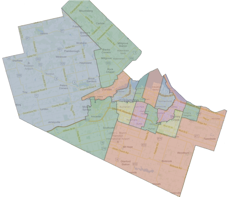
Hamilton's Ward Boundaries (Joey Coleman map overlay on Google Maps background)
As a Hamiltonian, I am often surprised when Barton and Sanford is referred to as the "north end", or City staff use "north end" to describe the industrial sector between Sherman and Woodward, or apartment buildings along Queenston Road in Stoney Creek are in the "east end", or the the stadium is in the "east end", or Westdale is called Hamilton's "west end", or Parkdale and Queenston is called "Stoney Creek".
With Hamilton being a large amalgamated city, even the terminology used for the lower city is being forced to change.
Arguably, the entire lower city is now "North Hamilton" - especially with the rapid expansion of Hamilton south since the opening of the Lincoln Alexander Parkway, growth in Upper Stoney Creek and Glanbrook, and the inclusion of agricultural lands to the south of the urban boundary.
As a local journalist living in Hamiltonian, I have strong opinions on when these terms should be used.
People who live in these communities - especially those along boundaries that are not exactly clear, but even when the boundaries are clear - have stronger opinions still.
Those opinions will differ from mine and official political boundaries.
What do these terms mean? What are the hidden and not so hidden meanings?
The term "North End" is most often used to indicate - secondhand - that a neighbourhood is poor or crime-ridden. It's usually dropped when referring to Hamilton's true North End in a positive story.
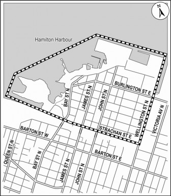
Official North End neighbourhood boundary (City of Hamilton graphic)
When writing about the booming real estate of the neighbourhood that is geographically defined as the North End (North of the CN mainline, west of Wellington), the term "Hamilton's waterfront" is often used to clarify the use of North End for geographical purposes.
This secondhand negative meaning is why Barton and Sanford is called "north end" in a crime story, or "north end" is used to refer to Jimmy Thompson pool in the context of the area being a lower-income neighbourhood.
City staff will refer to pollution in Hamilton's north end, or poverty in Hamilton's north end when they are referring to neighbourhoods well outside of the traditional north end - even when the term was used commonly to refer to all residential areas north of the CN mainline tracks.
Those who grew up in the north end and found successful careers use the term to denote the adversity they've overcome and the character that was built growing up in a poor community where personal honour was the most important currency, since money was hard to come across.
I now use "North End" to refer solely to the North End Neighbourhood, or for historical context for someone who grew up north of the CN mainline and east of Lottridge. (From my own experience growing up, I see the area along Beach Road to be very different than Keith neighbourhood of Wentworth North.)
East End and East Hamilton
East End is an interesting term to define, both geographically and for social meaning.
Personally, I've decreased my use of the term "east end" in favour of using neighbourhood names, key landmarks, and intersections to place a story in East Hamilton.
To me, East End refers to the former "blue collar" culture of an area where steelworkers lived close to the factories that provided plentiful good employment and the strong union culture that came from those neighbourhoods.
That culture is no longer homogeneous in any East Hamilton neighbourhood, and East Hamilton neighbourhood cultures I find are guided more by recent waves of immigration than social class.
I use "East Hamilton" for stories east of Gage Avenue, but mostly past Ottawa Street. I personally feel that Ottawa Street belongs to both East and Central Hamilton.
Ottawa Street also serves as the boundary between Wards 3 and 4, but I've never found ward boundaries to be useful for splitting geography in the Lower City.
Hamilton Police have a divisional boundary at Sherman Avenue, causing incidents at Sherman to sometimes be called East End.
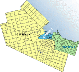
Hamilton Police Divisional Boundaries in 2015
I can't quite define "East End" in my mind. I could during my childhood, when there was greenfield on the Hamilton side of the Stoney Creek border. Now, Hamilton and Stoney Creek's border is a paper boundary for the most part. (More on this boundary below.)
If there is an "East End", surely it's the area east of the Red Hill Valley? However, I don't hear people living north of Queenston Road from the Valley to Centennial Parkway (which I still call "Highway 20") refer to themselves as "East End".
South of Queenston, they don't either.
South of King, the "Davis Creek" name is taking hold among those who identify with Hamilton and other parts of East Hamilton here identify themselves with Stoney Creek.
East of Highway 20, there is Riverdale. This neighbourhood is clear in its identity as Riverdale.
There is no area which I can clearly identify as "East End" today.
What is the east boundary of East Hamilton, when does it become Stoney Creek? This is my favourite boundary because of how the political boundary is not disputed, but the localisms are.
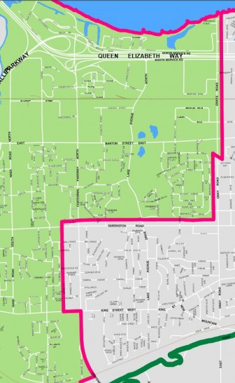
Hamilton - Stoney Creek boundary in the Lower City
I ran in Ward 5 for School Board Trustee in 2000, and this was the first time I realized just how strongly some residents feel about an affinity towards Stoney Creek - despite officially living in Hamilton.
The delivery area of The Stoney Creek News offers a good boundary of those living within the political boundary of Hamilton who identify as being in Stoney Creek.
I found when I was going door-to-door during the 2000 election, people living east of Quigley Road and south of Greenhill Avenue in the Vincent neighbourhood tend to lean towards saying they live in Stoney Creek.
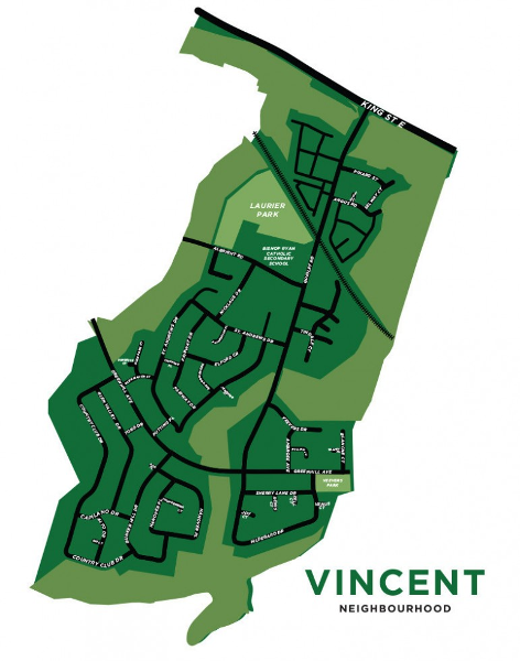
Jelly Bros map of Vincent neighbourhood
The developments east of Greenhill in the Gershome neighbourhood are mostly post-2000 era construction. (It is the last of that gap between East Hamilton and Stoney Creek that I knew growing up.)
When I ran in 2000, the families in Gershome identified more with Stoney Creek than Hamilton from my subjective experience.
East of Nash Road between Queenston and King is where many of my friends from Glendale Secondary School lived. All of them identified with Hamilton.
Going door to door, I didn't encounter many people referring to themselves as being part of Stoney Creek in that neighbourhood either.
I wonder if, much as the homes north of Queenston, this is because they are well connected by transit to Hamilton proper and most of the homes were built a few decades ago.
Riverdale is interesting because the boundary between Hamilton and Stoney Creek isn't Queenston Road itself. Instead, it runs along an old survey line just north of the street.
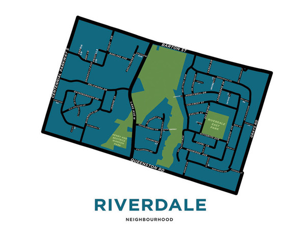
Jelly Bros map of Riverdale neighbourhood
All the apartment buildings and businesses on the north side of Queenston are in Stoney Creek. 9 Riverdale Drive is also in Stoney Creek on the northwest corner of Queenston and Riverdale.
Everything else north of Queenston Road is in Hamilton's Riverdale neighbourhood.
I find the residents of detached homes in Riverdale - especially those east of the Stoney Creek waterway - identify with Stoney Creek.
Interestingly, apartment buildings along Queenston Road west of the Stoney Creek waterway seem to lean towards identifying with Hamilton. The street addresses along Queenston Road in Stoney Creek continue their numbering from Hamilton side and the apartments are within a block of the Eastgate transit terminal.
There is fierce pride in Riverdale as an identity among the apartment buildings south of Barton Street and west of Lake Avenue.
I write Riverdale for the apartment buildings within Hamilton, I describe the apartment buildings as being in Stoney Creek near Eastgate Square, and the detached homes as "in Riverdale along the Stoney Creek border."
Eastgate Square is almost always referred to as being in Stoney Creek. Except for a sliver of the parking lot at Centennial and Queenston, the entire mall is on the Hamilton side of the boundary. The mall self identifies as Stoney Creek.
Another interesting localism is the naming of the portions of Stoney Creek above the escarpment. Is it Upper Stoney Creek or Stoney Creek Mountain?
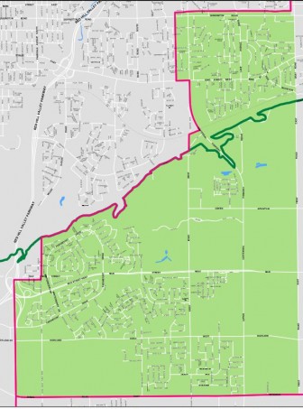
Map of Ward 9 Stoney Creek showing the urban portion of Upper Stoney Creek. (City of Hamilton map)
Growing up, I always heard it referred to "Upper Stoney Creek" and its neighbourhoods as "Valley Park" or "Satellite City". I never heard "Stoney Creek Mountain".
A Google search of the City of Hamilton website shows the two terms in use with 78 results for "Upper Stoney Creek" and 94 results for "Stoney Creek Mountain".
Over at the Hamilton Spectator we find 538 results for "Upper Stoney Creek" and only 60 results for "Stoney Creek Mountain".
A search of the Stoney Creek News finds 361 results for "Upper Stoney Creek" and only 29 results for "Stoney Creek Mountain"
Most of the "Stoney Creek Mountain" usages are more recent, indicating a possible change in terminology that coult reflect the increased inflow of new Hamiltonians or the direct connection of Upper Stoney Creek to Hamilton Mountain following growth that came with completion of the Red Hill Valley Parkway.
A search of the Hamilton Spectator archives going back to 1991 finds 538 results for "Upper Stoney Creek" and 266 for "Stoney Creek Mountain".
I'm sticking with "Upper Stoney Creek" for now, but accept that our localisms change.
I expect "Stoney Creek Mountain" will become dominant, especially with growth in Binbrook creating more of an east-west flow of people on the escarpment compared to the past when residents of Upper Stoney Creek had to travel down Highway 20 to Eastgate for shopping and services.
Hamilton Mountain is interesting to cover for me as I lived on the Mountain when nearly everything south of Limeridge Road was active farmland. There were farms north of Limeridge Road to the east of Upper Ottawa as well in the early 1990s.
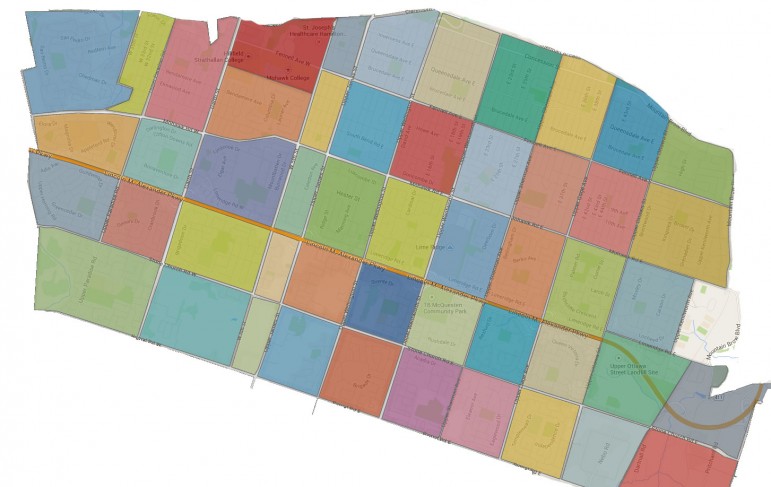
Hamilton's Official Mountain Neighbourhoods, adapted from Jelly Bros
Today, the Mountain is fully developed with the exception of a few pockets in Ward 8 south of Stone Church Road. Stone Church Road and Rymal Road are both busy arteries and traffic on the Mountain seems much busier to me than the Lower City.
What are the neighbourhoods of the Hamilton Mountain?
I tend to use the divide the Mountain by east, central, and west using the ward boundaries with Ward 6 being east, Ward 7 being central, and Ward 8 being west.
Within Ward 6, I use the Linc, Kenilworth Access, and Mohawk Sports Park as key landmarks. As Mountain streets are on a grid pattern, I'll almost always note the nearest major intersection.
For Ward 7, the Linc and Limeridge Mall are major landmarks. Stories in the Concession Business Improvement Area are noted as being there. I've seen Concession referred to as the North Mountain. I find the term confusing and don't use it. Major intersections are noted in most stories.
Ward 8 has the Linc and Mohawk College. Major intersections are noted in most stories.
I'm just going to say it: I can't stand the term "West End" that is sometimes used in local media.
West of the Downtown, I use the neighbourhood names for Strathcona and Kirkendall. Both have strong neighbourhood identities.
West of the 403, it's either Westdale, Ainslie Wood, Main West for the stretch of multi-res buildings approaching Wilson Street, and McMaster for the campus itself.
I lived in Dundas for a year, in University Gardens. For terminology, I'll note University Gardens, Pleasant Valley, and Downtown Dundas as neighbourhoods.
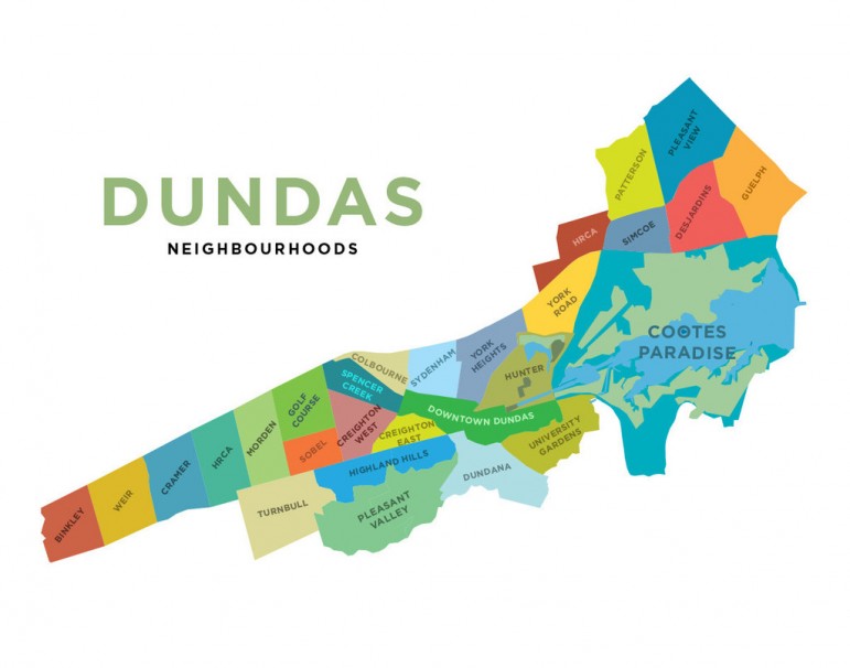
Jelly Brothers Map of Dundas Neighbourhoods
Otherwise, I'm noting location by citing the nearest major street such as Governors Road, Syderham Road, York Road, or King Street.
Downtown Stoney Creek, Upper Stoney Creek, and Valley Park are my choices for the older parts of Stoney Creek. For lower Stoney Creek, I tend to use the nearest major north-south road as the landmark.
Winona, of course, gets referred to as Winona. That is all of Stoney Creek east of Lewis Road.
I don't wish to be barred from the Peach Festival for daring to call it East Stoney Creek. Long-time Winona residents often remind me how they fought against amalgamation with the Town of Stoney Creek in the 1970s. Don't ask them what they think of the 2000 amalgamation.
Tapleytown in Upper Stoney Creek is referred to as such, with a description of its location.
Here's a question I haven't answered, where does Binbrook end and Glanbrook begin?
With the rapid growth of the Binbrook urban area, this question has become harder to answer. Officially, Glanbrook is the agricultural area of the area south of Hamilton and Stoney Creek.
Substantial areas of this farm land is zoned within the urban boundary expansion.
For purposes of my stories, I'll use Binbrook for the existing urban area, and proposed developments.
Mount Hope is clearly defined.
For the reminder of Glanbrook, I'll use reference points such as Highway 6, major intersections, and proximity to Binbrook and Mount Hope to describe location.
I use the Ancaster Meadowlands for the newer parts of Ancaster east of the 403 and Old Ancaster for the downtown area of Old Ancaster.
Major intersections are used for other areas of Ancaster.
Alberton, Carluke, and Jerseyville are referred to by their community names in stories, reflecting their continuing unique identities. Duff's Corner's remains a historical landmark at the intersection of the former Highways 2 and 52.
Flamborough is many communities: Carlisle, Copetown, Freelton, Greensville, Lynden, Millgrove, Rockton, Sheffield, and Waterdown.
There are official boundaries for each of these communities.
Generally, I'll use the community that individuals in my stories self-identify with. Someone may be just outside of the boundaries of a rural settlement, but still identify with it.
I'll use major intersections to try to place stories.
I'm put out my view of Hamilton's localism. I'm sure many of yours may differ. I'm especially interested in what your thoughts are for local boundaries in the former municipalities.
This article was first published on ThePublicRecord.ca.
By ItJustIs (registered) | Posted February 16, 2015 at 11:19:40
I heartily applaud this effort, Joey. Regardless of your personal view on things, whether I'd agree or disagree, the fact that you've taken the time to analyze something that's not issue-driven is testimony to your belief in Hamilton deserving better discussions (and coverage of same). Well done.
By KevinLove (registered) | Posted February 16, 2015 at 11:27:39
What about Durand or Corktown or Beasley?
Or "Downtown"? Different people have different opinions on what is or isn't "Downtown."
Comment edited by KevinLove on 2015-02-16 11:29:48
By Reality Check (anonymous) | Posted February 16, 2015 at 12:26:10
Well done Joey
By Kathy P (anonymous) | Posted February 16, 2015 at 14:07:08
Sorry Joey but Copetown was never part of Flamborough. It was part of the old Ancaster township and now is par of Ancaster.
By Fred Street (anonymous) | Posted February 16, 2015 at 15:27:10 in reply to Comment 109198
Typically the City identifies Downtown Hamilton as framed by Queen/Wellington/Cannon/Hunter.
goo.gl/PzEYuc
The Downtown Transportation Master Plan seems to go with Queen/Wellington/Hunter/Barton.
EcDev has repeatedly tweaked that envelope in the interests of expanding access to property incentives.
2006: goo.gl/rEKTi8
2011: goo.gl/ANSHtz
2014: goo.gl/OCExP9
By Noted (anonymous) | Posted February 16, 2015 at 15:39:45 in reply to Comment 109200
Beverley Township?
"It is our intention to divide our work into six letters, namely, Sheffield, Clyde, Kirkwall, Rockton, Copetown and Troy, each settlement by itself, and in doing so we may at times have to retrace our steps in order to pick up some important event that I may have passed unnoticed, and I have done my best to get all accessible information, and get it as accurately as possible....
IN taking up the Copetown letter I find that it will be necessary to divide it into three sections, Copetown proper, Orkney, and Lynden, taking each section or settlement by itself, and in driving over this section in search of information upon this almost lost subject, I find that it is not an exception to the other parts of the Township, for I think sometimes that it is like hunting up the dying to hear about the dead, and only for the commendable efforts that are being made in every part of the Township to bring to the front every possible link that connects the past with the present, my task would be more difficult than it is, a knowledge which, if not obtained very soon, must go into oblivion, for here as in other places the ship is nearly loaded ; and the man has got his hand on the bell-rope to give the last call ; they are spreading her sails; every banner and pennant is flying, and they are awaiting the command of the Captain to cut her away from her moorings." – John A. Cornell, 1889
archive.org/stream/pioneersbeverly00cornuoft/pioneersbeverly00cornuoft_djvu.txt
By ScreamingViking (registered) | Posted February 16, 2015 at 16:03:01
Glanbrook used to be Glanford (west part) and Binbrook (east) a long time ago. I think the townships were brought together to create "Glanbrook" when Hamilton-Wentworth region was created in the early '70s. But Binbrook retained its own identity because of the village at Hwy 56 and Binbrook Rd., which has gotten larger with more recent housing developments there.
I grew up in the "East End" but toward the escarpment not far east of Red Hill Valley - even back then (1970s-80s) there were very fuzzy definitions of what constituted the east end and to some my neighourhood wasn't really in it. The dividing line for Stoney Creek always differed depending who was telling you about it.
Westdale for me was always the original "planned community" - roughly west of Longwood to McMaster, north of Main... but my mental map didn't include the neighbourhood north of King to Princess Point.
To me, downtown was always Queen to Wellington or so, and north of Cannon south to Charlton or the escarpment, but its definition does vary depending who you talk to. Some people include more of the lower city when they refer to it; some may even mean the whole lower city from 403 to the east end.
Flamborough is such a huge area... I tend to use the community names too when talking about specific parts.
By Fred Street (anonymous) | Posted February 16, 2015 at 16:08:06 in reply to Comment 109202
Both, possibly. (Hub of the Universe and all that.)
web.library.mcgill.ca/CountyAtlas/Images/Maps/TownshipMaps/wen-m-beverly-s.jpg
web.library.mcgill.ca/CountyAtlas/Images/Maps/TownshipMaps/wen-m-ancaster.jpg
By JoeyColeman (registered) - website | Posted February 16, 2015 at 17:21:41 in reply to Comment 109198
Downtown is Wellington to Queen, Cannon to primarily Hunter. (I include Augusta's restaurant district in Downtown)
The neighbourhood boundaries for Beasley, Central, Corktown, and Durand are very clearly defined. There is overlap between the Central Business District and those neighbourhoods.
I generally use the neighbourhood names for residential and small business area stories/developments. Downtown for the office commercial, entertainment, and government areas.
By KevinLove (registered) | Posted February 16, 2015 at 17:52:34 in reply to Comment 109208
Interesting! I would include James Street north to the railway as part of Downtown. Particularly when the new train station opens.
To me, Downtown isn't a neat square on the map, but the functions one associates with downtown activities. But that's just my mental geography and take on things.
By JoeyColeman (registered) - website | Posted February 16, 2015 at 18:22:10 in reply to Comment 109212
James Street North of Wilson is primarily small business retail with residential above.
It's a commercial district, but in my opinion, not the central commercial district of the City.
James North is growing into its own unique community. Six storey wood frame structures should change the density of the area surrounding the "new" GO Station resulting in increased population density and a more vibrant small business environment.
I expect James North will become the descriptor of the King to GO North mixed-use neighbourhood.
By JoeyColeman (registered) - website | Posted February 16, 2015 at 18:23:42 in reply to Comment 109200
Copetown is on the border of both, and falls within Ward 14.
This does get to how people living in the community define themselves. Thankfully, I usually define Copetown as its own community to the west of Dundas on Governors Road.
By Fred Street (anonymous) | Posted February 16, 2015 at 18:59:15 in reply to Comment 109212
That definition is apparent in EcDev's Downtown Hamilton CIPA:
2006: goo.gl/rEKTi8
2011: goo.gl/ANSHtz
The zone has mutated to open eligibility to property investors further afield but even the latest patchwork is mainly defined by the area within Queen/Hunter/Victoria/CN tracks.
2014: goo.gl/OCExP9
The most focused definition of downtown is that of the Downtown Hamilton BIA:
investinhamilton.ca/wp-content/uploads/2014/12/DowntownHamiltonBIA-Map14.jpg
By Fred Street (anonymous) | Posted February 16, 2015 at 19:05:50 in reply to Comment 109208
"Downtown is Wellington to Queen, Cannon to primarily Hunter. (I include Augusta's restaurant district in Downtown)"
Possibly why the Residences at Acclamation development is described as "only steps from downtown" (Mulberry & James is only a block north of Cannon).
By Alternative (anonymous) | Posted February 16, 2015 at 22:24:32
Although the term "Lower City" had its beginnings as a geographical description, it has increasingly become used in the pejorative with the passage of time. Many people who live on the escarpment tend to "look down" on people who below the escarpment in more ways than one. There is an Upper James Street but no Lower James Street, an Upper Ottawa Street but not a Lower Ottawa Street. Why must there be a "Lower City"? It would be nice if a more respectful alternate name like "Original City" could find its way into the local Hamilton lexicon.
By jason (registered) | Posted February 16, 2015 at 22:41:51 in reply to Comment 109228
no chance. It's nothing but dump on the lower city decade after decade, but when any improvements are proposed, suburban/Mtn councillors flip out about how the 'lower city gets everything'...... It's their favourite past time. It's not changing anytime soon.
By Selway (registered) | Posted February 17, 2015 at 00:36:34
I don't find "lower city" pejorative; if mountain people use it that way (I wouldn't know) who cares? Upper Hamilton is just one large dormitory with a limited access highway running across it. Let's just stick to "lower city." All of the lower city nighbourhoods have names. The local media could just learn them and use them, maybe tagging them with a major intersection to lessen confusion, instead of using North End and East End interchangebly to indicate huge, vague areas.
What is interesting about the central part of the lower city is the historical layering still quite easily read there. Neighbourhoods and their residents used to be "parochial" in the original sense: much of life was centred on the church -- and the tavern, because church and extended families were the providers of such social security as there was; church and tavern were also information centres, where you found out about jobs etc. A lot of the taverns are gone but some remain, not serving the same function. Most of the churches are still standing, but most have big problems too. (In a sense, James North continues to fulfill those neighbourhood functions, as you can see by the groups standing around in front of Vasco Da Gama or Ola, or congregating in Mulberry or Home Grown.)
After the second world war the advent of the welfare state and of professionalized town planning effected rapid change in the organization of neighbourhoods, but you can still see lots of the early twentieth century city downtown. Most of the factories went away but some of the buildings are still there -- and some are even producing. I don't imagine any other city in Canada still has two operating garment factories within a few blocks of its central office towers, as we do. When you walk around the central city neighbourhoods you can see all the housing types ever, from occupier-built tarpaper shacks that were eventually clad in asphalt "brick" shingling to extremely elegant houses built for the local notables of the day. And so on. Except for the damned ground zero parking lots right at the centre, the lower city just has more being to it than the rest, it is dense in all ways.
But now you have planning and policy areas instead of traditional neighbourhoods and defining those areas has become very top down. For example, we live in the North End, and all of ward 2 is similarly composed of strongly defined historic neighbourhoods. But ever since urban renewal days the City has had a North End west and a North End east distinction on its books, with James as the divider. North enders generally don't like it, especially because it's an implied class distinction. When the City decided to respond to the recently established category of "Code Red" by setting up a number of "hub" organizations to generate positivity in the Red District, Central and North End became the policy fiction "Jamesville". On the other hand, the Setting Sail Secondary Plan, which sets out land-use and transportation guidelines, includes all of the North End, part of Central, and part of Beasley... And so on. The latest innovation is a quasi-planned "hub" - no relation to the entities initiated by the Neighbourhood Development Office- around the new James North GO station...
I'm just going to say it: I can't stand the term "West End" that is sometimes used in local media.
I find myself using "West End" quite often, but I might not mean what you mean: I use it to refer to Westdate and everything else between the 403 and Dundas. I could refer to "Westdale and Ainslie Wood", but I don't know that many of the people who live in Ainslie Wood East (403 to Cootes, I think), Ainslie Wood West (Cootes to Main West going up the hill) , and Ainslie Wood North (North of Main, West of McMaster) would even know that Ainslie Wood(s) is a (several) place(s).
Overlapping and confusing terms include West Hamilton, Ward 1 and West Town
Is the can't-stood term "West End" coterminous with "Ward 1"?
To the Police, "West Town" is more-or-less Ward 1 (Locke St. to Dundas)
And West Hamilton probably implies the old federal and provincial riding which more-or-less co-incides with "West Town".
By moylek (registered) - website | Posted February 17, 2015 at 08:47:59 in reply to Comment 109234
And West Hamilton probably implies the old federal and provincial riding which more-or-less co-incides with "West Town".
And to further confuse things, a once and perhaps future place is the old village of West Hamilton, still visible at Emerson, just north of Whitney where there is the rump of a commercial district with a few shops, a pub, a church, a cenotaph, and even an active lumber mill. That commercial zoning and the presence of the cenotaph might be enough to form the nucleus of a new West Hamilton village identity.
I don't know if the residents around the old West Hamilton village core feel as if they live in West Hamilton - partly because most of them are students who live there for only a few years.
By greenfingers (registered) | Posted February 17, 2015 at 14:40:12
When I first moved to Mary and Barton St. E. everyone in that neighbourhood referred to themselves as being in the North End if they were north of or near to Barton. Partially a socio economic statement but also a loose interpretation of the official boundary. Thanks for the great article Joey.
There is upper (up yours) Hamilton and lower (lower half) Hamilton. Rest is just marketing. ☺
By Sancho Panza (anonymous) | Posted February 19, 2015 at 13:31:04
I live north west of Mud & Winterberry, and I cannot for the life of me figure out how they came up with the ward boundary in the area of the Red Hill and the edge of the escarpment. (See Upper Stoney Creek vs Stoney Creek Mountain). It makes no sense.
In terms of localization, I've always called it Stoney Creek Mountain, and everyone who I talk to who lives/works in the area appears to call it the same.
You must be logged in to comment.
There are no upcoming events right now.
Why not post one?